

Places
Sorry, no places were found that related to your search.
Photos
Sorry, no photos were found that related to your search.
Maps
Sorry, no maps were found that related to your search.
Books
Sorry, no books were found that related to your search.
Memories
3,644 memories found. Showing results 401 to 410.
Selsdon Parade Residential Flat
My family and my father's before that (surname Kent) lived in Selsdon (84 and 32 Foxearth Road, 170 Littleheath Road, and 24 Benhurst Gardens) spanning c. 1930 - 1989. But at one point (after my father's death), my ...Read more
A memory of Selsdon in 1982 by
Happy Days
My memories of the caravan site go back to the 1940s when my parents had a caravan there. It was situated at the edge of the site where there is an open field and a footpath. I went back last July for the first time in about 60 years ...Read more
A memory of Swalecliffe in 1940 by
Wonderful Feelings
My mother was born in Leeds and most years we would spend some time there. I came to love Leeds; such a vibrant place compared to Lincoln where we lived. This picture evokes a lot of feeling. From the V J celebrations in 1945 onwards ...Read more
A memory of Leeds in 1945 by
June 2011
Well, I did visit Clements Hall last spring/summer 2011, after not seeing C.H in about fifty years ago. We parked at the keep fit-gym club and as soon as I got out of the car I turned around and saw the the playing field, known then as the ...Read more
A memory of Hockley in 1960 by
Walton Colliery
My name is Roland Mitchell. I worked at Walton colliery as a haulage hand. I worked alongside Percy Heckles, Alan Jennings, Phillip Casgoin and Phillip Redmond and a young lad by the name of George Bernard Shaw. We ...Read more
A memory of Walton in 1971 by
Early Years
I was born in 1967 in Tipton. I lived close to Victoria Park and have fond memories of sitting on the witch's hat swing which when looking back was sooo dangerous but fun. The metalic slide, made slippy from greased bread wrapping ...Read more
A memory of Tipton in 1967
Hill O Beath My Home
Hill of Beath was a great place to stay when I was young, running round streets playing cowboys with Brayan Snedon, Ross Mickey, playing football and training with the Haws, going to the little shop on Main Street and ...Read more
A memory of Hill of Beath in 1990 by
Some Berwick Memories
I was a Dutch student of English and spent my summer holidays at a farm at Berwick in the years 1959-61. The farm was run by John and Chris Buckland, their phone number was RIPE 393. I can't remember the name of the farm (if it ...Read more
A memory of Berwick in 1960 by
Marsala Road Ladywell The Prefabs
I was only a few months old when our family moved to 122 Marsala Road, Ladywell in 1949. I was ten years of age when we moved from Ladywell to Dartford in August 1959 but there are many different and varied things ...Read more
A memory of Lewisham in 1958 by
Mrs. Bleby Kirkly Park Road
My memory is of very happy days living at 35 Kirkly Park Road which was a children's nursery run by Mr and Mrs. Bleby when I was there from 1952 til 1957. There were around 20 of us children living there. Many of us like ...Read more
A memory of Lowestoft by

Captions
1,151 captions found. Showing results 961 to 984.

Helston Penrose Walk 1913 Penrose Walk runs from the bottom end of Coronation Park down to the Loe and follows its shore to Penrose.

In 1910 the Borough of Wallasey was formed. This took in the UDCs of Egremont, New Brighton, Leasowe, Poulton, Moreton, Seacombe and Wallasey.

Lynn (the King's was added by Charles I in recognition of this town's loyalty to the Royalist cause) lies about 1.5 miles inland, where Lynn Cut meets the Great Ouse.

On the north-east side of the county, Hose is situated close to the Nottinghamshire border in the Vale of Belvoir.
On the north-east side of the county, Hose is situated close to the Nottinghamshire border in the Vale of Belvoir.

Tregaron is a small nucleated town, probably based on a Welsh maerdref where the lord held court. It grew rapidly during the early 19th century, when it became a popular meeting place for drovers.

The next sequence of views shows the Victorian and later development of Sutton to the south of the railway line.

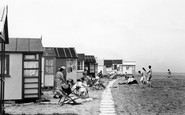
This is a detail of the chalet zone which sprang up behind the 1897-built Esplanade (right), between the waterworks and the Salt House on Pitfield Marsh (left).

This is a wonderful piece of social history from the 1950s caught on film. Liverpool Road was a long road running from Church Street, Eccles to the airport out at Barton.

The Egremont ferry started in 1835 from a small pier, and was taken over by Wallasey Corporation in 1862.

From the modern, bustling entertainment of Drusilla's Zoo Park we finish this chapter in Wilmington, on the east side of the Cuckmere River.

The Romney, Hythe and Dymchurch Railway is said to be the world's smallest public railway service.

Henry Milling & Co's family grocers with its familiar Ovaltine sign soon disappeared; Gaskell's Farm Shop stopped selling bacon, and time was running out for John Manners' 'Gents & Boys' clothes shop.

Situated five miles north of Sheffield, the large parish of Ecclesfield was semi-industri- alised by the late 18th century.

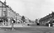
Two cars enter the Ewell Road from the main village crossroads watched by a policeman on point duty at the foot of Station Road (later renamed Station Way).

Dragwell, adjacent to A R Tarlton's chemist's shop (left), runs between Derby Road and Nottingham Road on the north side of the church, which stands prominently above the River Soar.

St Katharine was the patron saint of millers, saddlers, wheelwrights and teachers - all trades and professions which appropriately flourished in Ickleford.

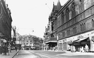
George's Hall dominates the left side of our photograph, and the London North Western Hotel the right side.

Skirting the modern shopping centre, our tour reaches Stert Street, which runs south towards the Market Place; in the 1890s, it was one of Abingdon's main shopping streets.

This impressive flight of sixteen locks, regarded as the finest in Britain, is also known as 'the Staircase'. This photograph was taken from Marsh Lane in Rowde.

The 15th-century building in the foreground has had a variety of uses, including that of a public house named The Cricketers which ran from the mid 19th century until its closure in 1909.

On the left bank is the single track Bristol & Portishead Pier & Railway, which opened as a broad gauge line in April 1867 and was worked by the Bristol & Exeter Railway.

Market Street was notorious for traffic congestion even in the 1880s.
Dragwell, adjacent to A R Tarlton's chemist's shop (left), runs between Derby Road and Nottingham Road on the north side of the church, which stands prominently above the River Soar.
Places (0)
Photos (0)
Memories (3644)
Books (0)
Maps (0)

