

Places
2 places found.
Those places high-lighted have photos. All locations may have maps, books and memories.
Photos
11 photos found. Showing results 61 to 11.
Maps
10 maps found.
Books
Sorry, no books were found that related to your search.
Memories
102 memories found. Showing results 31 to 40.
Plashet Grove
Before & during the Second World War my uncle was an electrical engineer & had a shop in Plashet Grove opposite Washington Road. Unfortunately I wasn't born until 1946 & so I have no knowledge of the shop except some photos ...Read more
A memory of Upton Park by
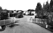
Pinehurst Caravan Site
What a surprise to find a picture of Pinehurst Caravan Park, very likely the only postcard to survive! The site was in Hewarts Lane, Rose Green. My late mother and my great-aunt purchased a caravan 'Romany' on the site and ...Read more
A memory of Aldwick in 1958 by
Personal Reflections
I was born in Sandleaze, Worton in 1957. I was brought up at 1 Mill Road near the Marston boundary. I remember many things about the village especially the Rose and Crown Pub and the Mill. I remember with pride the war ...Read more
A memory of Worton by
Park House Estate Blackwater
Hello, If you know about this place please add your history, I live in Beech Drive which is in the grounds of old Park House, A30, we understand it had tennis courts and a drive from the A30, its boundery is with the ...Read more
A memory of Blackwater in 1900 by
Park Hill Farm Stramshall Parish
My grandfather was enlightened in many ways. He permitted the children from the western side of the town, to bathe and swim, at The Pipe, boundary with campbells, The Basin, near to stramshall footpath, subject to ...Read more
A memory of Stramshall by
Park Court ~ Balham Park Road
My Aunt & Uncle (Ella & Cecil Forbes) lived in a two bedroom flat in Park Court in Balham Park Road from 1948 & throughout the 1950s and I spent much time staying with them as my parents ran pubs in The City. ...Read more
A memory of Balham in 1955
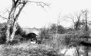
On The River Mole
The River Mole forms the county boundary here, south-west of the church, so the right bank in the view is in Sussex. This is Long Bridge, seen from Church Meadow, now a more manicured space. The bridge carried the London to Brighton road for many years; it was rebuilt in the 1970s.
A memory of Horley
Old Dagenham
I REMEMBER THE NAME O'DELL AND WHEN I SAW THE ADDRESS IT RANG BELLS. I LIVED IN FARM CLOSE AND MY NAME WAS MARGARET CLARK . OUR NEIGHBOURS WERE THE WOODARDS, THE READES, HART, MARKS, JAMES, BUTCHER. Others on the estate were the ...Read more
A memory of Dagenham by
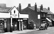
Nostalgia
The garage, owned if memory serves by the Harrison family, was always a magnet for a small boy, because in addition to selling petrol and repairing cars it also sold Meccano and Dinky toys. I also remember my grandmother buying me the Sunny ...Read more
A memory of Langwith in 1948 by
Captions
233 captions found. Showing results 73 to 96.

The River Stort formed the boundary between Hertfordshire and Essex and provided the transportation service for the malting industry in the town.

The River Welland is the boundary between it and Northamptonshire.

This is the only pier remaining within Yorkshire's traditional boundaries.

Within the Leeds city boundary most of the open areas between the townships gradually dispersed under an urban sprawl of industrial and housing development.

Within the Leeds city boundary most of the open areas between the townships gradually dispersed under an urban sprawl of industrial and housing development.

The three boundaries of Sussex, Hampshire and Surrey all meet by the bridge across the River Wey.

The New Pier (it dated from 1891) runs along the skyline of this view of the seafront, with its former Boundary Archway (separating Burton's town from Hastings) on the right.

The stamp of ancient man is here too - there are traces of defensive works on the summit, while on the lower flank are Iron Age field boundaries or lynchets.

London, Brockenhurst began to expand during the second half of the 19th century and continued to develop in the 20th century, establishing itself as a convenient and popular inland resort within the boundaries

This is not a beautiful scene, but some effort has been put into designing the brick boundary wall, flagpoles and railings.

The splendid golf course was also part of Herbert Raphael's grand plan for Gidea Park Garden Suburb, providing it with a green and pleasant boundary to the east just as Raphael Park did to the west

Many Taunton families and thousands of incomers were relocated on to the vast new housing estates that sprang up around and beyond the borough boundary.

The 14th-century gate is shut every night, marking the boundary between city and church.

Situated to the west of Romsey, Sherfield English lies close to the county boundary with Wiltshire.

Raised above the road, behind a rather forbidding local stone boundary wall, the rather stumpy three-stage crenellated west tower is all that remains of the medieval church.

South-east of the village, a lane crosses the county boundary with Bedfordshire along the upper reaches of the young River Ouzel.

At the time these photographs were taken, Warrington was still part of Lancashire but, after the boundaries were changed in the 1970s, it became part of Cheshire.

Ringwood stands on the banks of the meandering River Avon, at the New Forest's western boundary.

At the foot of St Dunstan's Hill, this mock-Tudor fronted Charrington's pub stands at the crossing point of the old parish boundary of Gander Green Lane with the Sutton by-pass, which had been constructed

The original village was in front of the manor house: such was the power and influence of the local landowner in those days, that the settlement was demolished and rebuilt outside the park boundary.

Close to the county's southern boundary, the village of Yardley Gobion is flanked by the Grand Union Canal and the River Tove.

Changes in administrative boundaries and education policy were later to alter its status significantly.

St Lawrence's Church provides good views towards Wincanton and the hills on the boundary with Dorset.

The Plain, as it is known, lies just to the east of Magdalen Bridge, representing the boundaries of the old city.
Places (2)
Photos (11)
Memories (102)
Books (0)
Maps (10)

