

Places
Sorry, no places were found that related to your search.
Photos
Sorry, no photos were found that related to your search.
Maps
1,353 maps found.


Books
3 books found. Showing results 937 to 3.
Memories
2,047 memories found. Showing results 391 to 400.
13 St Andrews Street Emma And Walter Stacey
My gran Emma jane Stacey and grandfather Walter john Stacey lived here . My father used to take us on the cremyl ferry across to Edgecombe and then we would bus it to Millbrook.. Sometimes we would be ...Read more
A memory of Millbrook by
Southall Havelock Road 1960ish
I remember the dairy in Havelock road i was a milkboy helping a milkman on a round in a bedford van doing as far as heathrow airport driving across the tarmac to the aircraft hangers, try that now, i remember waiting early ...Read more
A memory of Southall by
Training Pit Ponies At Oxclose. Ryhope
Training Pit Ponies at Ryhope Oxclose was a row of 5 terraced houses owned by the Colliery and located at the top of the lane which passed the eastern side of the Cricket field. At the Western end of 5 terraced ...Read more
A memory of Ryhope by
Sandhurst, Berkshire: Elsa Stone's Octagonal House.
In about 1945 my grandparents took me by bus (or train?) from Reading down to Sandhurst, shortly after the death of a distant cousin, Elsa Stone, who had had an octagonal house built during the 1920s. ...Read more
A memory of Sandhurst by
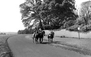
Horse Riding Memories In 1960's Rural Dinas Powys
I may or may not be the young person riding the pony in this photograph. The first lessons were conducted without a riding hat ( not an obligation in those days ) and without jodhpurs - expensive ...Read more
A memory of Dinas Powis by
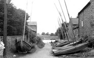
Ferry Lane
We called this "Ferry Lane",though the old chain ferry across the river Ouse formerly operated by Mr Atkinson was long gone even in 1955. The sailing Dinghys were left there by members of the Yorkshire Ouse Sailing Club and you can just see the ...Read more
A memory of Naburn by
Walking To West End School From Persondy
Walking along Sycamore Street, Persondy, even now in my mind, I passed, the Roberts' house next door, the Walkers, the Ryalls, can't remember the next house but she was German and very fiery, then the Williams, ...Read more
A memory of Abercarn
Football By The Flats
I lived on Daglen(sp) drive opposite the flats in the early fifties. Dad worked at Ford in Dagenham and older sister Brenda went to Bonnyfield? Primary. We played football on the grass outside the flats wandered in the woods ...Read more
A memory of South Ockendon
Telegram Boy
First to Ingram Infants then to Beulah Boys then to Ingram Boys. Remember the Davis Theatre the Flee Pit on the corner of Surrey Street and Scarbrook Road. The Red waistcoat man who sold curtains and the Sarsparilla Van . I was a telegram ...Read more
A memory of Croydon by
Growing Up In Belvedere
I spent most of my younger years up to about 5 years old living in Nuxley Road with my grandparents and my aunts. The house was next to Hammonds the Bakers at the bottom end near to Stream Way. I am not sure what the shop is ...Read more
A memory of Belvedere by
Captions
1,059 captions found. Showing results 937 to 960.

Looking along the High Street past the beleaguered Burton Memorial, one would see little change today in the buildingscape.

This is the main shopping area of the town; the architecture matches the period of rapid development after the railway arrived.

On the right of the photograph is the 15th-century God's House Tower, formerly the south-east gate of the old town and one of the earliest artillery fortifications in Europe.

Bath Street curves away northwards from the Square and its junction with the High Street.

A water mill has stood here since Norman times, but this red brick corn mill dates from the early 1800s.

A scattered village on a hilltop in the centre of Sussex. Friendly societies began here at the Five Bells Inn in 1782.

Tenby was described thus in a Victorian guidebook of 1895: 'Tenby stands on a tongue of limestone rock, ending in a green promontory, which is crowned by the ruins of the old castle, and is now pleasantly
Tenby was described thus in a Victorian guidebook of 1895: 'Tenby stands on a tongue of limestone rock, ending in a green promontory, which is crowned by the ruins of the old castle, and is now pleasantly

The Marine Lake covered what had been fifty acres of wet sand, which was one of the favourite haunts of sand yacht enthusiasts.

Aberdour in the Kingdom of Fife, lies between Burntisland and Dalgety Bay, just across the Firth of Forth from Edinburgh.

The size of the Looe Hotel in Fore Street reflects the growing tourist industry, which was stimulated at Looe by a railway branch that had been connected to the main line system just seven years before

The camera looks north across the Golders Green Road/North End Road crossing.

This was originally a terrace of very large houses built by Edward Welby Pugin. They failed to sell, and the terrace was converted to a hotel in 1869. In 1873, Pugin was bankrupted.

This pond with its island is a most attractive feature in the outer part of the town. While it is somewhat municipalised nowadays, it is very ancient.

The church of St Margaret was rebuilt in 1852 and has a tower dating from 1507, which is just visible through the trees. The Pigeon House is a medieval yeoman's house.

As well as excursions up the Fal, ferries operated to Flushing and St Mawes Castle. Larger excursion steamers were employed on runs to the Lizard and Penzance.
The Marine Lake covered what had been fifty acres of wet sand, which was one of the favourite haunts of sand yacht enthusiasts.

This old coaching inn is one of many in Daventry which stood on the London to Holyhead turnpike.

Shaw developed as part of Crompton and by the early 1900s it had 29 spinning mills.

This village stands on the south-west edge of the Isle of Ely. In the 17th century the fens around Sutton were drained by farmers with the help of wind pumps.

Seaside bustle on the promenade, built as the old Upper Walk between the town and the Cobb Harbour in 1817; it is now known as Marine Parade.

In thirty years, this scene would be reinterpreted to become the Broadway. Gone would be the village pump, the pond and the water splash.

This village of great beauty is said to be the most photographed in Hertfordshire.

Now around to the south-west side of Glastonbury, where Wearyall Hill lies between the town and the river Brue. The name is a corruption of 'Wirral Hill', a deer-park established by the Abbots.
Places (0)
Photos (0)
Memories (2047)
Books (3)
Maps (1353)

