

Places
2 places found.
Those places high-lighted have photos. All locations may have maps, books and memories.
Photos
11 photos found. Showing results 161 to 11.
Maps
10 maps found.
Books
Sorry, no books were found that related to your search.
Memories
102 memories found. Showing results 81 to 90.
Eastville Park Bs5
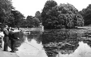
Eastville Park is a large park with a small lake, just to the east of the M32. The lake at Eastville Park was instigated as part of a social scheme by Ernest Bevin (a well respected westcountryman) who later became Minister of ...Read more
A memory of Bristol by
Eastville Park
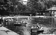
Eastville Park swimming pool was built in 1905, and the lake in 1909, with the present boathouse dating from 1925. Since then, local road building has resulted in the loss of the original boundaries of the park and its walls, gates and ...Read more
A memory of Bristol by
East Ham In The 1960s
In February 1963, when I was six and a half, my parents bought their first house, in Thorpe Road, East Ham. It was and had been a very cold winter, and when we moved in we had difficulty opening the back door, as there was so ...Read more
A memory of East Ham in 1963 by
Early Days In Failsworth
I was born in 1947 in boundary park hospital, as it was then. My mum and dad lived in Holt Lane in Failsworth. I can remember the Argyll Mill as a working cotton mill which was just down the lane. My mum was a housewife and my dad ...Read more
A memory of Oldham by
Early Memories
My birth on 30 Nov 1946 at 34 Oldberry Road, Burnt Oak, is where it all started for me, but my mother & her parents moved into the house when it was built for the LCC. She's 89 now, but recalls that she, as a 9-yr-old in 1928, ...Read more
A memory of Burnt Oak in 1946 by
Early Childhood In Romford
I was born in 1953 and lived for the first 3 years in an old house in Junction Road (Number 8) with my parents and Mum's mum (Granny). The back garden of the house seemed to be a jungle and had its end boundary with ...Read more
A memory of Romford by
Ealing Village
From the year I was born (1968) until the mid nineties I was brought up in Ealing Village, just off Hanger Lane. I have many fond memories of doing such things as building camps behind the tennis courts or in the White house, riding my ...Read more
A memory of Ealing by
Dunsmore People And Happenings Remembered
PREFACE TO THE SECOND EDITION In 1995, when the first edition of this history was published, it seemed incredibly optimistic to have had three hundred copies printed for a market which was ...Read more
A memory of Dunsmore by
Dorstone In The Golden Valley
In many parts of the world the countryside is largely unclaimed, untamed, even uninhabited; consider, say, the large swathes of Australia’s Kimberley region, Indonesia’s Kalimantan, or the interior of Baffin Island. ...Read more
A memory of Dorstone in 1940 by
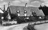
Doctor's Cottage On Church Lane
This lovely cottage looks like the one which was located near where I used to live and go to school back in the 1960s. If I am right then the curved space in the bottom right of this picture was the boundary of a ...Read more
A memory of Balsham in 1969 by
Captions
233 captions found. Showing results 193 to 216.

This scene is of Banstead Downs, which are actually outside Sutton's boundaries, south of Belmont station.

The wall on the extreme right of the photograph once marked the boundary of West Cheam Manor.

Gone the row of cottages, probably only thirty years old when the photograph was taken, and now gone is the Red House, an 18th-century building behind its boundary wall, but out of sight to the extreme

In later years the cross defined monastic lands; one boundary was at the hamlet of Cross Slack.

Beating the parish bounds was important – the ceremony impressed upon young people the extent of the boundaries.

The law was limited to the forest of Hardwick, including the 18 towns and villages within its boundary.

To the right is Church House, which shortly before this view was taken had ceased to be a farmhouse; the flint walls in front are remnants of its barns, retained as boundary walls.

Still close to the Yorkshire county boundary and south- west of Harworth, Oldcotes village is situated at the crossroads of the A634 and A60; Main Street runs east from the A60 Doncaster Road

Oxfordshire's boundary was on the right bank with the riverside path until 1974, when Abingdon and north Berkshire became part of Oxfordshire.

Behind the camera, built into the boundary wall, is a small stone plaque commemorating, what may well have been Britain's first fatal motor accident.

A horseman rides north-eastwards, along what is now St Andrew's Road towards Bradpole, when this was part of that parish before boundary changes brought the northern suburbs into Bridport borough.

The lodge became known as County Gates because this junction on the main Bournemouth-Poole road was also the boundary between both the two towns and Hampshire and Dorset.

Look at the timber windows with their coloured glass, the original front doors, the solid, yet attractive, garage doors, the original gates and boundary walls, and realise that all this has for the greater

The trees and flint wall in the photograph marked the southern boundary of the Warwick estate.

The priory occupied over 40 acres - there are remains of its flint boundary walls.

Back in the new city of Milton Keynes, Simpson is one of the villages it engulfed; but it is conserved within its boundaries.

Skirted by the Icknield Way on the right, the expanse of Therfield Heath originally stretched from the boundary of Baldock to Royston.

Street names intially included 'Reform Place 1835' to commemorate electoral changes after the Boundary Commission had reported: 'The chief trade arises from the manufacture of hemp and flax, and Allington

Hoddesdon was a small hamlet on its northern boundary, but when its church of St Paul was built, it broke away.

Visitors, when looking westwards from the pier in 1899, would have seen terrace after terrace of lodging houses, interspersed with the occasional Victorian hotel, stretching to beyond the Heene Parish boundary

The centre of the bridge marks the boundary of the West Riding and the Ainstey of York - a grant of land by King John to the city that contained some twenty villages.

The gentle Great Ouse not only formed the northern boundary of the village, but it was a main source of trade and communication with Huntingdon and St Ives.

In 1895, the borough boundaries were extended to include the Great Salterns, and in 1904, the whole island was incorporated into the borough.

In 1895, the borough boundaries were extended to include the Great Salterns, and in 1904, the whole island was incorporated into the borough.
Places (2)
Photos (11)
Memories (102)
Books (0)
Maps (10)

