

Merry Christmas & Happy New Year!
Christmas Deliveries: If you placed an order on or before midday on Friday 19th December for Christmas delivery it was despatched before the Royal Mail or Parcel Force deadline and therefore should be received in time for Christmas. Orders placed after midday on Friday 19th December will be delivered in the New Year.
Please Note: Our offices and factory are now closed until Monday 5th January when we will be pleased to deal with any queries that have arisen during the holiday period.
During the holiday our Gift Cards may still be ordered for any last minute orders and will be sent automatically by email direct to your recipient - see here: Gift Cards
Places
1 places found.
Those places high-lighted have photos. All locations may have maps, books and memories.
Photos
11 photos found. Showing results 841 to 11.
Maps
4 maps found.
Books
1 books found. Showing results 1,009 to 1.
Memories
1,368 memories found. Showing results 421 to 430.
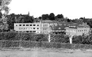
The Atlantic House Hotel
Back in 1971, I joined a friend from London on a surfing trip to Polzeath. I'm from America, and was in the middle of a year-long jaunt around Europe and North Africa. I hadn't gone surfing in several months and was ...Read more
A memory of Polzeath in 1971 by
Trevone
We emigrated to Pennsylvania from Accrington in June, 1954; I was seven years old. One year later we returned to England and settled in Farnborough in May, 1955. My father worked for Turk, Krish and Barstow, Solicitors, who were located ...Read more
A memory of Farnborough in 1955 by
Hythe Childrens Holiday Home
I too, stayed at this holiday home for children on the sea-front at Hythe in the late 1960's. The holiday was arranged by my primary school in the West Midlands, the home is no longer there. I believe it was owned and run ...Read more
A memory of Hythe in 1969
Sutton/Carshalton In The 50's
We lived in a block of flats, Weihurst Court, Carshalton Rd. This was at the top of Ringstead Road, where the trolley buses came up this steep hill. As a child it was fun to watch when the arms of the trolley came off the ...Read more
A memory of Sutton in 1943 by
Another Memory Of Weymouth
In the 50's Bertram Mills Circus used to come to town and I remember there was a great procession through the streets near the harbour, this included the elephants and the prancing horses! On Saturday mornings there were ...Read more
A memory of Weymouth
Mr Mc Donald's Guest House
I first went to Westgate in 1961 with my parents (I was born in 1956). My memories are of Mr McDonald's Guest House and the brass dinner gong in the hallway. Also memories of the cafe and Speedy Gonzales on the ...Read more
A memory of Westgate on Sea by
Family Holidays
I remember Market Street, there was a newsagents towards the bottom of the town (heading towards Colwyn Bay) that we use to get our newspapers from. Also one of the roads leading down to the beach and station used to have a lovely ...Read more
A memory of Abergele by

I Remember You
I used to live opposite you at No1 North Road. I am Mary Dodgson. I spent all the summers of the late forties leading the donkeys and ponies up and down the beach or with Rose Cummings and her son, Les Smith, who had the horse and ...Read more
A memory of West Kirby in 1948 by
Growing Up In Barripper Road
My parents lived at 23 Barripper Road (David and Mair Hallett) and my sister Mandy and I went to Miss Blights (Elmhurst Preparatory School) in Bassett Road. I remember walking past the farm at the top of the road (now ...Read more
A memory of Camborne in 1955 by
Queen Mum Opens New Dining Wing
I remember being in the Beeches Prep School at the time. Anybody else remember the staff I wonder? Miss Lambert in Kindergarten and Transition, Miss Cutler - Form 1, Miss Reid - Lower 2 and Mrs Cotton in Middle 2. ...Read more
A memory of Berkhamsted in 1960 by
Captions
1,130 captions found. Showing results 1,009 to 1,032.

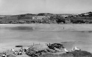
St Ives is seen from Draycott Terrace, overlooking cottages in Primrose Valley below and the curving sweep of the railway station beyond, most of which is now a car park.

In the decades following the First World War, Exmouth reached the heights of its fame as a holiday resort, thanks to the greater mobility offered by railway trains and motor vehicles

The long, sandy beach leading eastwards to Hengistbury Head began to be developed around 1870. The pier was built of iron in 1881, and measured 300 feet in length by 30 feet wide.

The cliff tramway was opened in 1884, replacing an earlier vertical hoist installed in 1870.

The crew of a Sheringham crab boat pose for the camera. These clinker built, double-ended open boats were approximately 18ft long and carried a dipping lug sail of up to 120 sq ft.

A late Edwardian scene before development took place along Grand Parade, and when grassy sand dunes filled the space where the Embassy Centre is now situated.

The boat lying on the beach in the fore ground, in Hugh Town harbour, is vaguely reminiscent of an ex-ships' lifeboat, and shows the rugged clinker-built construction of this type of craft.

Golden Cap rises at the centre, with tree-coverd Langdon Hill (top right) to landward.

These timber-clad cottages, standing at the foot of the white cliffs, are part of a small community which developed both as a bathing resort and as a residential quarter in the closing years
These timber-clad cottages, standing at the foot of the white cliffs, are part of a small community which developed both as a bathing resort and as a residential quarter in the closing years

Pwllheli (the name means 'saltwater pool') was granted its charter in 1355.

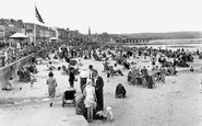
Here we have an early view of Towan Beach, with everyone overdressed for the seaside. A game of tennis is in progress on a court marked out in the sand.

Lloyds Bank used to operate from the house on the extreme right. These days it is a private house once more. Next door is the Catholic church of St Peter and St Paul.

Positioned on the Firth of Clyde, this seaside resort looks across the Firth towards Kilcreggan, Loch Long and Dunoon.

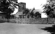
The inn was built in 1927 using traditional materials, especially local flint; its design makes it look much older then it really is.

Beyond the Bay Private Hotel and Madeira Cottages (left centre) are Hardown Hill, Stonebarrow Hill (centre) and Golden Cap (right). Seaward are a series of ledges.

The story of the demise of Dunwich, in medieval times a prosperous port until the ravages of the North Sea gradually demolished its soft, sandy cliffs, is one of the most romantic of the Suffolk coast.

Boats are on the Chesil Beach between Chiswell and Victoria Sqaure (top left), with Portland Harbour on the other side of the pebble bank (centre background), in a panorama north-westwards from Paradise

Recreational Facilities also with those who wish to experience invigorating walks by the sea during the sometimes less inviting off-season weather.

However, some areas of the Durham coast were polluted with spoil dumped directly into the sea from nearby collieries.

This is an early view of the bridge from the town side. Billy Moore's Boat Statoin (known to the local children as 'Noah's Ark') has still to make its appearance.

The lower end of the Bude Canal has a basin with a sea lock to allow ships to enter and remain afloat. Three vessels are in port, while a fourth one lies aground beyond the lock gates.

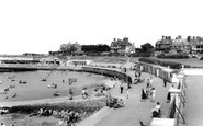
This popular seaside resort sits in a wide sweep of bay on the north coast, with wooded hills behind the promenade, which fronts miles of safe sandy beach.

Sandsend was just three miles along the sandy beach from Whitby.
Places (1)
Photos (11)
Memories (1368)
Books (1)
Maps (4)

