

Places
36 places found.
Those places high-lighted have photos. All locations may have maps, books and memories.
- Devil's Bridge, Dyfed
- Menai Bridge, Gwynedd
- Hebden Bridge, Yorkshire
- Pateley Bridge, Yorkshire
- Sowerby Bridge, Yorkshire
- Bamber Bridge, Lancashire
- Bridge of Allan, Central Scotland
- Victoria Bridge, County Tyrone
- Two Mile Bridge, Republic of Ireland
- Greta Bridge, Durham
- Three Bridges, Sussex
- Newby Bridge, Cumbria
- Bridge, Kent
- Marple Bridge, Greater Manchester
- Wootton Bridge, Isle of Wight
- Woodford Bridge, Greater London
- Dunsop Bridge, Lancashire
- Forth Bridge, Lothian
- Haydon Bridge, Northumberland
- Shotley Bridge, Durham
- Wisemans Bridge, Dyfed
- Two Bridges, Devon
- Stanford Bridge, Hereford & Worcester
- Mylor Bridge, Cornwall
- Calder Bridge, Cumbria
- Whaley Bridge, Derbyshire
- Kerne Bridge, Hereford & Worcester
- Stamford Bridge, Yorkshire
- Drift Bridge, Surrey
- Cowan Bridge, Lancashire
- Acton Bridge, Cheshire
- Stow Bridge, Norfolk
- Penny Bridge, Cumbria
- Four Mile Bridge, Gwynedd
- Eamont Bridge, Cumbria
- Sutton Bridge, Lincolnshire
Photos
10,057 photos found. Showing results 1,201 to 1,220.


Maps
1,153 maps found.
Books
Sorry, no books were found that related to your search.
Memories
2,061 memories found. Showing results 601 to 610.
A Walk From Shotgate Baptist Church To Wick Lane
My name is Kevin Mears, I lived in Wickford from my birth in 1958 until I got married in 1980. I shall describe my memories of Wickford as a couple of walks around the Wickford area. My first walk ...Read more
A memory of Wickford by
A Walk From Shotgate Baptist Church To The Nevendon Road Part 2 See Part 1 Below
Continued from Part 1 below. Next to Martins Bank was a record shop, where I remember going with my parents and standing listening to records in the small listening ...Read more
A memory of Wickford by
A Walk From Wickford High Street Down The Rettendon Raod
My name is Kevin Mears, I lived in Wickford from my birth in 1958 until I got married in 1980. I shall describe my memories of Wickford in the 1960s and 1970s as a couple of walks around the ...Read more
A memory of Wickford by
Growing Up In Tottenham
I spent the first eleven years of my life in Tottenham. We lived above the PDSA dispensary in Seven Sisters Road. My father worked for the PDSA as a vet, and I remember very clearly the queues of people waiting to have their ...Read more
A memory of Tottenham in 1950 by
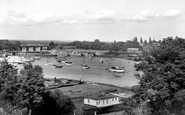
Bursledon Bridge
This picture is of the two Bursledon bridges over the River Hamble - the A27 road bridge in the foreground and the rail bridge behind it. Sarisbury Green is further up to the right on the A27 at the top of the hill. The photo is ...Read more
A memory of Bursledon by
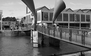
Pero's Bridge
The warehousing which dominated Prince Street, Narrow Quay and Prince's Wharf have been found new uses, largely cultural and media-based. The industry on Canon's'Marsh has gone, replaced by the new industry of tourism. With the ...Read more
A memory of Bristol by
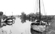
Acton Bridge
Hello Laurie My dad had the boat 'Jan' - I still see Roger & Jean from time to time. We still have a boat on the Weaver at AB, and she is called 'Triton'. I have a brother called Peter and my parents were called Peter & ...Read more
A memory of Acton Bridge in 1960
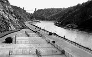
Tennis Courts Portway Bristol
These Clifton Tennis Courts alongside Bristol's Portway road were built just after the road was opened. The new built Portway from Bristol to Avonmouth a very modern road in its day. The wide A4 Portway trunk road passes ...Read more
A memory of Bristol in 1930 by
Growing Up
I remember the long hot nights when we would all play football down the park till it got dark, the shops on the main street when you could buy any kind of sweets (or nick them if you were skint he,he), the bridge that divided the two ...Read more
A memory of Salsburgh
Lovegreen Street
My maternal grandmother lived in Lovegreen Street from around 1900 until 1957 when she moved in with my family in Framwellgate Moor. Her name was Parkinson and I believe her house was the first one as you turned the corner into the ...Read more
A memory of Durham in 1950 by
Captions
2,231 captions found. Showing results 1,441 to 1,464.

This scene of the parish church of St Peter at Addingham, standing in its walled churchyard on the village green and reached by a stone bridge over the beck, has not changed substantially since this photograph

This wooden bridge survives. Authorised by an Act of Parliament in 1781, it carried traffic until 1971.

What a tragic loss this superb 1833 suspension bridge was. Designed by William Tierney Clarke, it was replaced in 1923.

The single-deck trams were used on routes with low railway bridges. Note also the wooden stalls used as tramway stops.

This picture was taken from the junction with Bridge Street. Just getting into the picture on the right is the recently completed Becketts Bank.

The Long Bridge over the broad waters of the River Taw was certainly built by 1300, but it may be a hundred years or more older.

Andressy Bridge, built in 1884, joining Andressy Island to the town, is featured in this view from Hay Walk.

The photograph was taken from a bridge built in the 1930s to replace the delay-producing level-crossing which carried the Great North Road.

Standing on the east bank of the Thames, below the bridge, this medieval inn is noted for its cruck construction – note the large curved timbers in the gable wall – and for the fact that Jerome K Jerome
Standing on the east bank of the Thames, below the bridge, this medieval inn is noted for its cruck construction – note the large curved timbers in the gable wall – and for the fact that Jerome K Jerome

The cast iron bridge was built in the 1850s, with Sir Charles Barry, the Houses of Parliament architect, acting as consultant. To the right is New Scotland Yard, which was completed in 1890.
The dated 1960s architecture of Oxford House opposite faces demolition - clearance of the Hayes/Bridge Street site is scheduled to make way for a vast new retail complex.

The Square lies at the north end of the Long Bridge. The building to the right is the red façade of The Athenaeum, built in 1888, which houses the museum and a collection of fossils.

There are two massive bridges in the town, and before the line east reaches another viaduct at Golcar, it passes over these smaller seven arches opposite the town of Linthwaite.

The lane in the centre of the village that crosses the bridge is called 'Bow Wow', while not far off is another named 'Upper Up'.

This is taken from the 'tongues' in the middle of the River Brett, adjacent to the two 18th-century hump-backed bridges. The Peacock is early 15th-century.

The ford was replaced by a bridge over the beck in the winter of 1966/67.

The High Street, across the Witham via Town Bridge rebuilt in 1913, presents a mainly late Georgian character with mostly three-storey frontages to the pavement edge, but many of these conceal earlier

Perhaps some of these cars came from Wessex Motors that sold Morris, MG, Riley, and Wolseley cars in nearby Bridge Street.

The Methodist chapel is on the left, whilst ahead is a railway bridge. The station is to the right, on the old London and South Western Railway line from Waterloo to Exeter.

This photograph shows the corner of High Street and Bridge Street. The Electricity Service Centre and the London Central Meat Company have been replaced by a beauty salon and a florist.

This bridge is first recorded as 'Dertebrygg' on the Assize Rolls of 1356; since then it has been enlarged several times as traffic has grown heavier.

Two Bridges is at the junction of all the ancient packhorse trails that cross the moor, and was thus the obvious meeting place for miners from all points of the compass.

The bridge over the Avon is in the distance. On the right, a shop front has been added to an earlier building. From the pavement the change would be almost invisible.
Places (284)
Photos (10057)
Memories (2061)
Books (0)
Maps (1153)

