Places
26 places found.
Those places high-lighted have photos. All locations may have maps, books and memories.
- Cemmaes Road, Powys
- Six Road Ends, County Down
- Road Weedon, Northamptonshire
- Severn Road Bridge, Gloucestershire
- Roade, Northamptonshire
- Berkeley Road, Gloucestershire
- Harling Road, Norfolk
- Road Green, Devon
- Builth Road, Powys
- Cross Roads, Yorkshire
- Steele Road, Borders
- Cross Roads, Devon
- Four Roads, Dyfed
- Road Green, Norfolk
- Biggar Road, Strathclyde
- Clarbeston Road, Dyfed
- Five Roads, Dyfed
- Eccles Road, Norfolk
- Grampound Road, Cornwall
- Morchard Road, Devon
- Wood Road, Greater Manchester
- Four Roads, Isle of Man
- St Columb Road, Cornwall
- Clipiau, Gwynedd (near Cemmaes Road)
- New Road Side, Yorkshire (near Silsden)
- New Road Side, Yorkshire (near Cleckheaton)
Photos
14,329 photos found. Showing results 1,321 to 1,340.
Maps
476 maps found.
Books
5 books found. Showing results 1,585 to 5.
Memories
11,058 memories found. Showing results 661 to 670.
Harriott Brothers The Butcher's Shop
My Father was Arthur Harriott who owned Harriott Brothers Butchers Shop (which can be seen at the bottom left-hand corner of the picture) together with his Brother, Edward. We lived in "Old Sarum" which is the ...Read more
A memory of Droxford in 1950 by
Stilings Pharmacy Courtenay Street
I have just bought a print of Frith's postcard of Courtney Street in 1955 and am delighted to see the premises named "Stilings Pharmacy" on the right of the picture. My father ran this business for the Misses ...Read more
A memory of Newton Abbot in 1940 by
My Memories Of Caversham
I lived in Caversham in 1970-1972 at 11A Bridge Street, above the hairdresser's shop. It was owned by a Mr Simmonds, who was our landlord. There was a newspaper shop about 3 doors up from where we lived. There were our ...Read more
A memory of Caversham in 1970 by
My Grandma & Aunt
Some years ago I gave my mother a book of Old Weybridge photos for Mothering Sunday as this is where she was brought up. Imagine her surprise, on seeing this picture of Queens Road in Weybridge, to realise that the two people on the ...Read more
A memory of Weybridge by
Church Path, Mitcham And The People That Lived There
I was born in Collierswood Maternity Home, a very short time before it was bombed during the Second World War. The year was 1944. My family being homeless were housed in requisitioned properties in Mitcham. ...Read more
A memory of Mitcham in 1944 by
Omnibus Driver's Marriage In 1907
My grandfather's brother Albert Charles Greenfield was an omnibus driver in 1907 who married at The Church of the Ascension. His family lived in Birley Street near Clapham Junction. His wife Elizabeth Penfold's family ...Read more
A memory of Battersea by
Greenwich In The 1940s And 1950s
I was born, during the Battle of Britain, at 8, Roan Street. Our back yard bordered St Alfege's churchyard. The house is not there any more because it had to be pulled down after the war. We had several 'near-hits' ...Read more
A memory of Greenwich by
Hart Hill School 1954
I was born in 1949 and entered Hart Hill School in 1954. Those were the times when 5 year olds were taken to school by their Mums for about one week into the new term! There were so many kiddies in the surrounding area of Abbotswood ...Read more
A memory of Luton by
Bordon Council School
I was at the original Bordon Council School from 1937 to 1943. You can see the rooves of the old school behind the huts erected after the war when it became Weyford junior school. Mill Chase secondary Modern was later erected on the ...Read more
A memory of Bordon by
Little Boy's Heaven
In 1961 or 1962, as a small boy of 5 or 6 my mum, brought me to Hednesford to visit her grandmother, my great-grandmother, Emily Chetwyn. A diminutive lady, we, the children, called her little nana. I believe she lived in the end ...Read more
A memory of Hednesford by
Your search returned a large number of results. Please try to refine your search further.
Captions
5,036 captions found. Showing results 1,585 to 1,608.
On the other side of the road, in a glimpse from the past, there are three sailors most probably from HMS Mercury at East Meon.
Strolling pedestrians observe the beach from the cliff top along Narrowcliff Road. The open space of the Barrowfields behind is still preserved for the benefit of all.
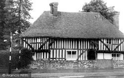
This is Old Farm House, an old Wealden-type hall house on Chatham Road. This house has been restored and is typical of 15th-century building in the wooded Weald.
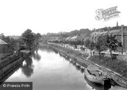
By 1901, the Riverside Road development of the 1880s and 1890s was maturing. This view also shows the old towpath, with moored barges, prior to the improvements for pleasure boating.
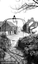
The road here winds down towards the sea, past the church of All Saints, with its decorative wrought-iron arch. Behind the church is an attached farm and tithe barn.
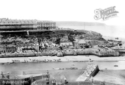
The bathing machines wait for customers on Scotch Head (right), and so do the stalls along Pier Road (centre). Were they selling seafood?
Lake Road, with houses overlooking the main lake, is undoubtedly a delightful place to live.
Morcombelake, situated on the high road between Lyme Regis and Bridport, is now famous as the home of the Moore's biscuit factory.
This cottage was believed to have been in the Guildford Road, and not demolished until the early part of the 20th century.
The Farnham Road (curving gently to the right) has recently been widened, and a row of poplar trees removed. The cottages are of different ages, but were probably refronted c1800.
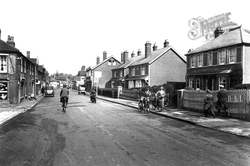
The array of chimney pots is an indication of the importance of the coal fire in those days.The cyclist is perfectly safe riding across this almost deserted road.
Both public house and petrol station prospered with the increasing volume of traffic on a road that the Edwardian topographer Sir Frederick Treves had described as 'a delightful walk'.
This view looks down on the hillside villas from the road which winds up to the Temple Hotel, which dates from the 1760s.
Maybe the constant traffic on neighbouring Evesham Road puts people off.
Hipperholme is at the busy intersection of roads from Brighouse, Halifax, Denholme and Leeds. The Co-op store (1889), left, is now a motorcycle showroom.
Victoriana and mock-Tudor set the scene around the unmade road of the Crescent. The large shop in the foreground specialises as a clothing and outfitting emporium.
The roads of the New Forest tend to be much busier these days than they were when this photograph was taken.
On the right is the Crafthole Methodist Chapel, built in 1867, while the house jutting out into the road on the left is now the shop and Post Office.
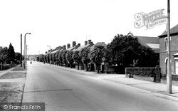
This is an attractive approach road into the town centre of Sleaford. The grass verge has gone to make way for a cycle path.
The town developed around the Old Portsmouth Road over Bagshot Heath from the early 19th century, and most of the buildings in this picture are Victorian.
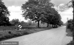
The speed restriction sign would allow the motorist to savour the open road, travelling though the attractive country lanes that criss-cross this rural part of Sussex.
The road across the square is the A30.
Blackburn Road is at the very heart of the town. The first building on the right is the Market Hall, and next to that, in the centre of our photograph, is the Town Hall.
The road from London leads naturally into Cheltenham's High Street, which is one of the original thoroughfares of the town.
Places (26)
Photos (14329)
Memories (11058)
Books (5)
Maps (476)


