

Places
5 places found.
Those places high-lighted have photos. All locations may have maps, books and memories.
Photos
9,649 photos found. Showing results 1,901 to 1,920.


Maps
18 maps found.
Books
13 books found. Showing results 2,281 to 13.
Memories
4,612 memories found. Showing results 951 to 960.
Cluggies Pond
I obviously don't remember the common in 1911, but I did live in Old Common Road number 15 from about 1943 until 1955. Where the children are sitting was The Common, and a herd of Fresion cows were often grazed there. Old Common Road ran ...Read more
A memory of Cobham by
South Benfleet Memories Of Summer Holidays
The photo of Station Hill reminds me of many happy days spent at my aunts house further down the hill ,she lodged in a lovely house with a balcony across the front owned by a couple Em and Bert who owned ...Read more
A memory of South Benfleet by
The Bringing Of Buckland Lower Lodge Into The 20th Century.
I am Jeannette McNicol (nee Elliott). My brother John and I moved there with my parents ,when I was 13 years old and he was 12. I had found the house when we were having a picnic ...Read more
A memory of Buckland in the Moor by
Stoke Road Blisworth.
We moved to Stoke Rd Blisworth 1975 six new houses were built opposite the post office,Mr & Mrs Freestone lived across the road they made us very welcome on one occasion Mr freestone removed a window when my wife locked ...Read more
A memory of Blisworth by
Wartime Memories
My mother and I were evacuated to Dacre Banks in 1941 when I was only 1 year old. We stayed until I was 4 and my first memories are at Dacre Banks. We lived on a farm just outside the village, where we had to walk up to the ...Read more
A memory of Dacre Banks by
Little Boys Home South Darenth/1938/War Time
remember being packed off to this boys home, well it was a self contained village really. every amenetie was taken care of church just inside the gates...school,,,,about 8/10 houses..the experience was quite ...Read more
A memory of Bromley by
The Caddick Family
1946 was the year that our family life in Nancledra began. What a relief it must have been to our parents, Peggy and Arthur Caddick to move into Windswept Cottage. The war years in London were over and they both felt a huge sense ...Read more
A memory of Nancledra by
Growing Up In The 70's
I moved to Pantymwyn in the 70s when I was 4. I have wonderful memories of growing up there. So much so that after 20 years of travels and adventures I have once again returned to live in our beautiful village. One time I ...Read more
A memory of Pantymwyn by
Mascot
I remember the Manor House in Child Okeford, my mother worked for the Glassbrooks the then owner s of the manor, this was about 1943/44 and a battalion of the Newfoundland Army were billeted in the grounds. I as a 6 year old boy became ...Read more
A memory of Child Okeford by
Farnham Royal
I remember walking from home on the britwell estate to school at St Anthony RC Primary or to st Anthony RC church walking past Travis court now a private housing development and past the village hall with Farnham royal men's club ...Read more
A memory of Farnham Royal by
Captions
5,016 captions found. Showing results 2,281 to 2,304.

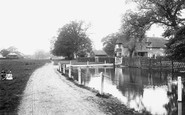
This later view of the pond is worth comparing to the earlier photograph of the same scene. Horses have given way to the ubiquitous motor car, and the village is catering for the car-borne tourist.

The house to the right of the arched entrance at the far end of the street is where the poet Chaucer once lived.

Part of the village is clustered around the top of a ravine. Notice the steep steps in the lower foreground, dropping away toward the sea.

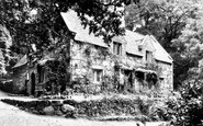
The old abbey just outside the village was founded in 1411 as a Benedictine hospital, but at the Dissolution it came into the hands of the Courtenay family who made it into a residence.

St Anne's church, consecrated in 1833, was built on a slope above the village near the site of the old church of the same name which had been attached to St Germans Priory.

Combeinteignhead takes its name from the valley which runs down to the Teign estuary at Combe Cellars.

It is hard to believe that this narrow road was once part of one of the major highways of England which had linked London and Chester since medieval times.

The centre of the village, with its attractive houses round the green, is marked by a market cross reminding us that Henry III had granted a license to Thomas de Greystoke for a weekly market and fair

There are two old yew trees here, and in 2000, to mark the Millennium, numerous cuttings were taken and planted throughout the village.

The village street at Bothenhampton (middle distance, left to right), with suburbia beyond, seen from the vicinity of Quarry Farm with an apple orchard and thatched cottages above

The mill is just south of the village on the Birkey Burn. The miller's house is dated 1728, and the three-storey mill building is also 18th-century.

The village flourmill was powered by two overshot waterwheels. The mill is pictured when it was still in working order.

This is the junction of Station Road (right) and, until the by-pass was opened, the main Stowmarket to Ipswich road. In the foreground is the Greyhound, with a delivery being made to the side door.

In this view the church seems to close the end of the village green. The three groups of cottages are timber-framed and date from the 17th and 18th centuries.

Just off the main road through unspoilt Bilsdale is the northern part of the village of Chop Gate. Bilsdale Hall is hidden behind the trees (centre).

We can see the village of Clun in the valley, with the keep of its old castle standing guard. Actually this castle was less a military stronghold than a centre for hunting.

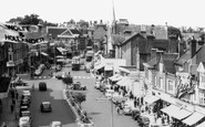
C M Topp the grocer (far left) is still trading. There was also a newsagent here. Just off the main street in North Road is the Methodist church.

Underneath this main road flows a stream that rises from a spring under the church of the Holy Rood, built in the 12th century.

The gaunt ruins of the Neville's castle built in the early 1380s dominate the skyline of the village of Sheriff Hutton, nine miles north of York.

Witchampton's flour mill closed before the Second World War, but the remains of the huge mill wheel, including its tree trunk shaft, can still be seen outside Flour Mill House.

This is a view of the real centre of the village looking up Oakham Lane.

Down the street stands Welton's church, dedicated to St Martin and distinguished by its square 14th-century tower. Inside is an ancient tub-shaped font, said to be Saxon.

The building to the right of this image is the Bull, known as the Bull's Head in the 17th century.

Clifton upon Teme's name is rather misleading, for the village itself stands a considerable distance from that river.
Places (5)
Photos (9649)
Memories (4612)
Books (13)
Maps (18)

