

Places
7 places found.
Those places high-lighted have photos. All locations may have maps, books and memories.
Photos
264 photos found. Showing results 321 to 264.
Maps
28 maps found.
Books
Sorry, no books were found that related to your search.
Memories
357 memories found. Showing results 161 to 170.
So Far Away Yet So Near
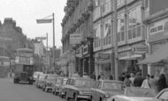
Such a familiar sight - the High Street with what looks like a number 47 RT AEC bus approaching. I actually lived in Coney Hall, but Bromley was only a 5d ride away (or 6d to the North if going to the Odeon or Pullman ...Read more
A memory of Bromley by
Faint Remembered Memories
I was born in 70 Thornlaw North in 1945, my parents were Herbert and Josephine Mary Cumming and my sister was Joan. I believe that the people next door were the Dunnets (Salvation Army). I used to play with Eileen Toy who ...Read more
A memory of Thornley by
Princess Margarets Visit
I too am from Six Bells, and lived in Richmond Road and also Princess Street before that. If anyone remembers the picture in the papers next day of her visit, I was the little girl playing with her ducks in the cast iron ...Read more
A memory of Six Bells in 1950 by
Memories Ofpalmers Buildings
We used to live in Gateshead but because father was away in the RAF he thought we should live closer to his brother who lived at 116 High Street East, Wallsend, so we managed somehow to get a house at 16 Third Street, ...Read more
A memory of Wallsend in 1942 by
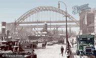
Trams, Markets And Bright Yellow Trolly Buses
With big hugs from waiting family on one of the many platforms that was Central Station, we hurried though the noise and clouds of steam towards the station exit and into the sunlight...my eyes ...Read more
A memory of Newcastle upon Tyne in 1940 by
Down Street
How many people remember the Lall Elf, on King Street, all of it and Nelson Street were partly demolished or empty, we would catch pigeons or look for the nests, there was hundreds of pigeons, people moved out and pigeons moved in. The ...Read more
A memory of Maryport in 1960
Horden Memories
Hi, my name is Lorraine, my surname was Humphreys at the time I spent my early childhood in Horden with my nana and grandad, both sadly gone now. I lived at 90 Seventh Street, I went to school on the top road we used to call 'the tin ...Read more
A memory of Horden in 1971 by
Biddulph,Early 1960s,Fondest Memories.
My father was transferred from a North East Mining Community,to a beautiful place called Biddulph.While he worked hard in the pits,we enjoyed many long days playing in some of the most wonderful places of ...Read more
A memory of Biddulph in 1962 by

The Real Heart Of Dagenham
We moved to Dagenham from Plaistow in East London when I was two years old. We moved to Leys Avenue, on the Rookery Farm estate. It was out in the sticks then with the remainder of Rookery Farm still in business with cows ...Read more
A memory of Dagenham in 1950 by
Swimming At Flag Bottom
I remember as a little kid in the 50's going through Borsdane Wood with my mam n' Aunty Liza - we'd take egg n' tomato butties with us and always head for the Flag Bottom. This was our cheap holiday / Wigan week, I think it ...Read more
A memory of Hindley in 1951 by
Captions
439 captions found. Showing results 385 to 408.

Still close to the Yorkshire county boundary and south- west of Harworth, Oldcotes village is situated at the crossroads of the A634 and A60; Main Street runs east from the A60 Doncaster Road

This photograph was taken in the other direction to H277056 (page 35), looking east along Market Street.

This view is at the east end of the High Street at the roundabout where it joins the A30, in effect the northern by-pass.

Conduit Road runs north from Ock Street on the east side of the Albert Park estate, and the earliest buildings on it are this church group.

We are looking from Market Square south-east into Walton Street. The Bell had been reworked in 1919, and is still much the same.

The village has been given a sweeping bypass, Broughton Way, on its north side, reducing the volume of traffic negotiating Main Street and the area around St Mary's Church and Old Mill

The village has grown rapidly in the 20th century east and west along and parallel to the main road and northwards along the valley of a small stream.

Gallowtree Gate runs out of Granby Street and London Road as it drops down to the Clock Tower.

The Grand Union Canal emerges from the Braunston Tunnel east of Braunston village and descends past the village on a flight of six locks. This view looks west along the High Street.

With a plan based on its Roman predecessor, Noviomagus, this fine walled city is divided into quarters by North, South, East and West Streets, which all meet at the splendid Market Cross in the centre

war memorial replaced an earlier obelisk with gas lamps attached; this had stood in the middle of what was a sheep market until 1885, the livestock market then moving to a new site in Bury Street

Beyond the lovely garden there is an exquisite view of the east window and turret of the school chapel built by G E Street in 1865.

North of this east-west road, Little Bookham Street has some older buildings amid the suburbia and wide grassy verges.

Looking East from Wood Street An inn has stood on this site for 400 years.

Some of the flavour of the old village remains in this view today, which looks eastwards along Broadwater Street East.

Ockley is a very fine village along the course of the Roman road from London to Chichester, which has been known from Anglo-Saxon times as Stane Street.
The early period of its history has left a great deal of physical evidence in the street pattern as well as some buildings, while documentary references further flesh out the picture.

Until about 1970, one-way traffic passed under this gate-house into Sadler Street, the main road from London and Bath to Exeter.

The name 'Finkle' comes from a Viking word meaning 'angle' or 'corner', and this less than straight street has not changed its line since those times.

The camera looks east down the High Street, which opens onto Church Gate and Derby Road. Kegworth's origins lay in its medieval weekly market and annual fair.

South Luffenham on the river Thater is a 7th-century Saxon settlement with North Luffenham, now adjacent to the A6121 Uppingham to Stamford road to the north, an attractive village of narrow streets and

Parallel to Stratford Road and to the south of it is one of the grid of streets that were laid out for the town from the 1840s, starting at the east and then expanding westward as land was released
The camera looks east down the High Street, which opens onto Church Gate and Derby Road. Kegworth's origins lay in its medieval weekly market and annual fair.

Byworth is a very pretty village with a single winding street a mile east of Petworth; it is set on hilly ground above a small stream flowing in a steep valley towards the Rother.
Places (7)
Photos (264)
Memories (357)
Books (0)
Maps (28)

