

Places
26 places found.
Those places high-lighted have photos. All locations may have maps, books and memories.
- Cemmaes Road, Powys
- Six Road Ends, County Down
- Road Weedon, Northamptonshire
- Severn Road Bridge, Gloucestershire
- Roade, Northamptonshire
- Berkeley Road, Gloucestershire
- Harling Road, Norfolk
- Road Green, Devon
- Builth Road, Powys
- Cross Roads, Yorkshire
- Steele Road, Borders
- Cross Roads, Devon
- Four Roads, Dyfed
- Road Green, Norfolk
- Biggar Road, Strathclyde
- Clarbeston Road, Dyfed
- Five Roads, Dyfed
- Eccles Road, Norfolk
- Grampound Road, Cornwall
- Morchard Road, Devon
- Wood Road, Greater Manchester
- Four Roads, Isle of Man
- St Columb Road, Cornwall
- Clipiau, Gwynedd (near Cemmaes Road)
- New Road Side, Yorkshire (near Silsden)
- New Road Side, Yorkshire (near Cleckheaton)
Photos
14,329 photos found. Showing results 3,921 to 3,940.


Maps
476 maps found.
Books
5 books found. Showing results 4,705 to 5.
Memories
11,058 memories found. Showing results 1,961 to 1,970.
Woodhorn Village
I lived in one of the cottages at Woodhorn, my dad worked on the farm. I remember a big windmill behind the houses. We had no indoor toilet, had to go cross the back lane, and no bathroom, had a tin tub, we had hot water from the ...Read more
A memory of Woodhorn in 1954 by
Jumping Over!
We used to live in Phrosso Road, off George Vth Avenue, and I used to be allowed to go to Marine Gardens on my own, or with my friend Katharine Green. We loved daring each other to jump over the long channel of the fishpond! Oh what ...Read more
A memory of Worthing in 1965 by
Gervis Road Collyhurst Flats 1945 1964
My name is Tom Smith. I was born in 17 Gervis Rd, Collyhurst Flats in August 1945. My dad was Jack Smith and my mam was Ada; there were 6 kids, John, Mary, James, (me) Andrew, and Arthur. To me the flats ...Read more
A memory of Collyhurst in 1945 by
Eveswell
My father, John, was a doctor at his surgery/house, Corporation Road and I and my brother John plus mother and father were in the shelter when the mine was dropped. I remember a discussion later about loss of panel patients (Lysaghts and ...Read more
A memory of Newport in 1940 by
St. Catherines Church
I was at Mount Pleasant School as a boarder for 6 years from 1946 to 1952. The school was in Dalmeny Road but apparently was taken down in 1965. I have been trying to find anyone who attended this school. Before going to ...Read more
A memory of Southbourne in 1948 by
Childhood Memories We Never Forget
To anyone reading this; I was born Valerie Harding and lived in Wedges Mills and I remember so many things about my childhood in Cannock. The Maypole dancing at John Woods school, attending Church each Thursday ...Read more
A memory of Cannock in 1953 by
My Childhood In Southall
My parents were born in India. My grandfather settled in Africa and had a good job. When my father got married he stayed Africa where all my brothers and sisters were born. My dad was a carpenter by trade; he arrived in ...Read more
A memory of Southall in 1962 by
Lots Of Coal Dust
Born in 1942, my earliest memories of Thurnscoe was living at 25 Taylor street. When I was four we moved to 137 Thornley Crescent. I attended both Houghton Road Infants and Junior schools. One name sticks in my memory; Mrs Cook - ...Read more
A memory of Thurnscoe in 1942 by
The Pantiles And The Broadway
I was born in Hurlingham Road, off The Pantiles during the war. The air raid shelters were still there for many years, and the allotments. School was a walk to Bedonwell Primary, joining others on the way. Weekly ...Read more
A memory of Bexleyheath in 1947 by
Passfield Common.
This photo shows the common looking southeast towards Liphook. The common was a favourite haunt for Canadian troops and local girls during WW2. Spent many hours gathering bracken for bedding for my rabbits, and roaming across it's ...Read more
A memory of Passfield in 1940
Your search returned a large number of results. Please try to refine your search further.
Captions
5,036 captions found. Showing results 4,705 to 4,728.

This view looks at what amounts to 19th-century small-scale development along the Fleckney Road; the whole adds up to a very cordial rural scene, common over southern Leicestershire.

Iron electricity poles line the road; they are of a type only seen in this part of Sussex.

This lovely building is at the southern end of the High Street, in the former market place where the High Street meets Worcester Road and St John`s Street.

Bell Street, part of the original town of Sawbridgeworth, runs from London road eastwards towards the church and the school.

One of these very similar views shows the town on a bright summer day with the road thronged with vehicles and the pavements, benches and sea wall busy with visitors enjoying the Cheshire sunshine and

This broad expanse of the old Portsmouth Road is lined with pollarded trees.

Antiquity shows in the datestone (1660) of the Ram's Head, a coaching inn on the Ormskirk to Preston road. Tarleton's mossland was drained in order to produce crops.

The bus stop site is now the start of the sweeping Church Way inner relief road running behind the Arndale development.

A greensand village, it is slightly off the beaten track and quiet: or at least quiet west of the B3000 Puttenham Hill road, which links the A31 and the A3.

Marsh's stores and Ferring Motors' garage are on the opposite side of the road.

The road on the right leads to the church, dedicated to St Mary and built between the 12th and the 15th centuries.

It was originally on the main Leicester/Melton Mowbray road until 1810, when Edward Parsons, who also put in the turnpike at Kibworth, built what amounts to a two-mile bypass from Rotherby to Chalk

A splendid open car heads north, driving in the middle of the road. The house on the left had belonged to Dr Atkinson, who died in 1917.

The Lynge, a road in Laindon, was named after it, but no longer exists. In 1777 Chapman and Andre refer to Langdon clay, a clear indication of the nature of the soil here.

The new bridge allowed trams to travel beyond Clydebank to Duntocher; the fare from Kilbowie Road to Duntocher was all of a halfpenny!

Many villages have road bypasses, but Thorpe has a river bypass: through traffic uses a stretch of river created by the railway builders in 1844, and only leisure traffic calls here.

This lovely old building stands in Leighton Road, close to its junction with Wood Lane.

Its original value lay in the number of farms and steadings that lay on its route, but its main function today is to provide a relief from the traffic on roads closer to the east of the village

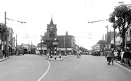
This view from the top of Morgan Street shows the 72ft-high ornamental clock tower and three of the four roads that lead from the Circle.

The archway leads to Dog Alley, the scene of one of Flora Twort's lovely paintings, which used to go through to St Peter's Road.

By 1955 both Russell Street and George Street had become one way, as the road signs indicate.

The furthest building on the right side of the road is the Saracen's Head, which was demolished in October 1957.

Summer Hill House, on the west side of Charmouth Road, was the Victorian home of the borough magistrate Walter Banfield Wallis.

Here we have another view of this heavily traffic-ridden main road with its shopping parade. On the right, Raymond's hair salon proudly advertises its offer of 'perms from fifteen shillings'.
Places (26)
Photos (14329)
Memories (11058)
Books (5)
Maps (476)

