

Photos
Sorry, no photos were found that related to your search.
Maps
9 maps found.
Books
2 books found. Showing results 625 to 2.
Memories
561 memories found. Showing results 261 to 270.
My Dad!
This is my father sat in the boat fishing on the Ancholme. His name is Jack Waters, a well known Brigg butcher (Waters and Sons) at that time, in business with his father and a brother in Wrawby Street. The photo was more than likely taken on a ...Read more
A memory of Brigg by

Mishaps In South Croydon
The pub in the middle distance on the right is The Red Deer. On the triangle, which is formed by the junction of Brighton Road & Sanderstead Road, where incidentally I later lived & two of my children were born, stood ...Read more
A memory of Croydon in 1959 by
Mayday Hospital Croydon
I am Irish and did nurse training in the Mayday Hospital from 1962 until 1965. The work was very hard, but we, the student nurses, enjoyed a good social life. I loved visiting all the shops in Croydon but had very little ...Read more
A memory of Croydon in 1962 by
Wells Bottom Farm
As children, my two brothers and I would go to visit Nannan (my paternal grandmother) at Wells Bottom Farm, near Sowerby Bridge, Ripponden. We would stop at the Blue Bell Inn for a drink of pop, the highlight of the long car ride ...Read more
A memory of Ripponden in 1960 by
Finchley Road & Frognal Station, Looking East
Having lived from 1938 to 1959 in the adjacent Lymington Road, which backs onto the Richmond-Broad Street Line serving this station and having passed it daily to and from my way to school/work, I would ...Read more
A memory of Swiss Cottage in 1950 by
University College School, Frognal
This was a Boys Grammar School. Their uniform was a cap and blazer with broad black and dark red stripes. During the war a number of the large houses in Frognal were evacuated by their wealthy owners, "For ...Read more
A memory of Swiss Cottage in 1950 by
Born At Barony Hospital
I was born, illegitimately, in Barony Hospital, Nantwich and lived in Church St, Crewe, moving to Cliffe Road when the "slum" houses were demolished and the police station was built there. I moved from my first school Brierley ...Read more
A memory of Crewe in 1954 by
The Happiest Days Of My Life
My maternal grandfather, Archie Greatorex, was the licensee of the Anchor Inn from 1957 until his death in September 1974. Most of my family holidays, until the age of 10, were spent with him. My parents used to pack my ...Read more
A memory of Wingham by
Glorious Summers
My father was born in Bodorgan in 1930, known as Jack Cefn Crin. I spent many happy times staying with my grandparents Thomas Lewis Hughes and Margaret Hughes. Such a beautiful place and still remember the taste of the carrots and ...Read more
A memory of Bodorgan by
Colliford Lake Park
When we used to have family holidays in Downderry year after year, we would visit Colliford Lake Park several times each holiday. It really was great fun there; the army jeep, the go cars, the play areas, the boats; there seemed to ...Read more
A memory of Bodmin by
Captions
650 captions found. Showing results 625 to 648.

The girl carrying a baby (left) and the children playing in the boats are noticeably not visitors.

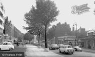
This broad expanse of the old Portsmouth Road is lined with pollarded trees.

'The sands', says the Frith title, but as you can see, central Morecambe has always had a pebble beach, especially at high tide.

Punch and Judy hold the attention of the formally-dressed crowd of holidaymakers in the South Bay.

Under Henry VII it was given to the Hobarts for several generations.

To celebrate the 21st anniversary of the founding of the Scout Movement, 56,000 scouts from around the world held their 3rd International Jamboree in Arrowe Park.

To celebrate the 21st anniversary of the founding of the Scout Movement, 56,000 scouts from around the world held their 3rd International Jamboree in Arrowe Park.

Stanhill is a small community on one of the B-roads between Oswaldtwistle and Blackburn. It was in this building in 1764 that James Hargreaves lived when he invented the Spinning Jenny.

Of all the villages that surround Durham City, old Brancepeth is particularly well steeped in legend and history.

This picture is remarkable for the diversity of personal transport it depicts. St Peter's Street is still as broad today as then, but it would be a brave cyclist who rode down its centre now.

This broad open space is a kaleidoscope of noise and colour on market day.

The expansive market place has long been the commercial hub of the town. On market days it echoes Yarmouth's seafaring traditions, the colourful awnings stretching out like waves to the horizon.

The village stands under the downs near the source of the Len and has a broad, attractive market square fringed with lime trees, which create a shadowed path over the uneven setts and cobbles.

Broadstone is named after Broadstone Farm, which in turn took its name from broad stones spanning a stream. One is outside the Stepping Stones pub.

This is a spectacular view from the top of Portland, with the expanse of the Chesil Bank on the left, stretching 16 miles along the Dorset coast to Barton Cliff, and the broad expanse of Portland Harbour

The three-storey Royal Lion Hotel (left) incorporates a Tudor building. King Edward VII, as Prince of Wales, spent a night here during a teenage walking tour in September 1856.

The modern Milford Haven grew in the 1790s and the port was to cater for the needs of the whaling ships, as they brought their cargoes here to be processed in blubber oil.

In the 17th and 18th centuries, the Quay was a scene of bustling activity with barges loading and unloading their cargoes.

The broad straight streets tell of land recovered from river and docks. The church tells of the human needs that followed.

The broad thoroughfare reflects not only the market town but also its link with the sea. Below the cobbles still runs the Belfast River, which once had quays allowing ships to come off the Lagan.

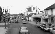
At the top of the High Street on the right is the Cowes Advertiser office, but just before that is the NSPCC charity shop.

During the 18th century, the roads Cherry Bounce, Chapel Street, Bell Road (now St Mary's Road), and George Street were all developing on the east side of the of the High Street and were in

AT LAST he [Troy] reached the summit, and a wide and novel prospect burst upon him with an effect almost like that of the Paci?c on Balboa's gaze.

It became quickly clear that St Mary's Church was too small for the parish. In 1865 the Church of St Peter and St Paul on Broad Street was opened; it became independent of the parish in 1880.
Places (0)
Photos (0)
Memories (561)
Books (2)
Maps (9)

