

Places
17 places found.
Those places high-lighted have photos. All locations may have maps, books and memories.
- Bridge End, Oxfordshire
- Bridge End, Lincolnshire
- Bridge End, Essex
- Bridge End, Bedfordshire
- Bridge End, Clwyd
- Bridge End, Warwickshire
- Bridge End, Surrey
- Bridge End, Durham (near Frosterley)
- Bridge End, Northumberland (near Hexham)
- Bridge End, Hereford & Worcester (near Tirley)
- Bridge End, Hereford & Worcester (near Bosbury)
- Bridge End, Shetland Islands
- Bridge End, Cumbria (near Carlisle)
- Bridge End, Northumberland (near Hexham)
- Bridge End, Devon (near Kingsbridge)
- Bridge End, Devon (near Sidmouth)
- West End, Yorkshire (near Pateley Bridge)
Photos
40 photos found. Showing results 641 to 40.
Maps
520 maps found.
Books
2 books found. Showing results 769 to 2.
Memories
1,925 memories found. Showing results 321 to 330.
Open Spaces And Industry
I visit family and friends occasionally on returning to my birth place of Bristol. I still enjoy as I did as a child 'The Downs' and 'Blaise Castle Estate'. Then particularly the paddling pool in the summer which we all ...Read more
A memory of Bristol in 1960
What Was It Down The Burn
In and about 1960 I was a boy who spent many an hour down the burn, at one end just below the station part of the burn had very sturdy concrete walls at either side, these walls were some sort of supports or ...Read more
A memory of Boldon Colliery in 1960 by
My Memories Of Salwarpe
I lived in the first house opposite the church, before we moved to Australia in 1963. Next door lived Dr Adenbrook (I think), next to the church lived the Hoods in the now college, mum worked for a Brenda & Bryan Mullens ...Read more
A memory of Salwarpe in 1960 by
Wiveliscombe Earliest Memories
I remember being taken to Wiveliscombe as a young boy in my Uncle Jim's dark green Standard Vanguard, he ran the Rock Inn at Waterrow 1954- 1965. He would take me to the toy shop at Wiveliscombe Square called ...Read more
A memory of Wiveliscombe in 1960 by
Bliss Full Childhood Memories
I have fond memories spent with my grandparents who lived at The Oaks in Girdlane, Mill Brow. I used to walk to Marple Bridge with my grandma to do the shopping. I was born in Stephouses, Hollywood Lane, Mellor ...Read more
A memory of Marple Bridge in 1960 by
Opposite The Grammar School
I attended Poole Grammar from 1956-64, and saw your house almost daily. The school then was almost opposite the house, it was torn down when the Seldown Bridge was built. The school was very overcrowded so we used the park in our lunch break.
A memory of Poole in 1960 by
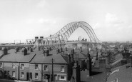
Construction Of The Bridge.
I lived in Albert Street only 300-400 yards from the Runcorn entrance to the bridge. I vividly remember watching the construction, fascinated by the huge trucks and pieces of steel being taken on to the bridge to be joined ...Read more
A memory of Runcorn in 1960 by
Good Ole Days!
My first school on moving from South London to 124, Brook Road was High Cannons at Well End. Then to Lyndhurst, a few teachers from memory : Tony Smith, Mr Thurston, Mr Fennel and who could forget Wendy Watford & her ...Read more
A memory of Borehamwood in 1960 by
Childhood
My Grandparents owned Pinwherry House and Pinwherry farm with around 550 acres during the 50/60's. Part of the Farm also extended to a large field and cottage on the other side of the Stinchar which was allowed access by a swing bridge ...Read more
A memory of Pinwherry in 1960
Wells Bottom Farm
As children, my two brothers and I would go to visit Nannan (my paternal grandmother) at Wells Bottom Farm, near Sowerby Bridge, Ripponden. We would stop at the Blue Bell Inn for a drink of pop, the highlight of the long car ride ...Read more
A memory of Ripponden in 1960 by
Captions
1,770 captions found. Showing results 769 to 792.

The railway between Dublin and Kingstown was the first in Ireland, and was opened in 1834. Semaphore signals can be seen behind the bridge.

In Saxon times, before many bridges were built, rivers formed real obstacles to travel, and ferries thrived.

Boats can be hired at the Swan's Nest Boathouse and at Clopton Bridge.
Designed by Sir John Fowler and Sir Benjamin Baker, the Forth Bridge cost £3,000,000 to build. Of the workforce of 4,500 men, 57 were killed in work-related accidents.

The remains of a Roman hypercaust, the heating system for a Roman bath, were discovered in Bridge Street in 1863 and subsequently relocated to the gardens by the Water Tower.

Built of cast-iron, the bridge was opened in 1863 and improved the city by giving direct access to the original railway station, which was situated within the city walls.

After the Dissolution, the abbey was left a ruin and many of its stones were eventually carted off and used to widen the old Leeds Bridge.

This stunning panorama looks south-east over the battlements and roofs of London's most celebrated building and towards the river and Tower Bridge.

In 1792, a company was formed by Lancaster merchants; they saw a canal as a way of getting cheap coal from Wigan and getting other goods out to the towns in the heart of Lancashire, and to the growing

Looking back across the bridge towards Salutation Square. The Cavendish County Theatre to the right has since been demolished and this area is now the site of the new County Offices.

Looking across the River Corrib at Salmon Weir bridge, built in 1818 to link the new courthouse (1815) and the old jail, whose site is now occupied by the new cathedral.

This is all pedestrianised now, and no double decker bus is to be seen in this part of the High Street. The High Street is in fact the Roman Ermine Street, and it goes all the way through the city.
Built of cast-iron, the bridge was opened in 1863 and improved the city by giving direct access to the original railway station, which was situated within the city walls.

Seen from the bridge, most of these buildings survive as cafes, gift shops, and the like. The prominent semi-circular gable on the right in the distance is the famous Roy's Stores.

The chain suspension bridge at the appropriately named Seaview leads out to the steamer landing stage. From here boats would arrive and depart on a daily basis to the mainland at Southsea.

The old road to Camelford and beyond, later becoming the A39, climbs steeply up Gonvena Hill from the bridge.

A steam launch - the 'Thistle' - is moored outside the Crown and Thistle pub's landing stage just above Abingdon town bridge. This pub, a 19th-century coaching inn, is still open for business.

There seems to be ample room beneath the wide arches of Llanfoist Bridge, but when the Usk floods the waters have often risen to the top of them and flooded the Castle Meadows in the foreground.

An obelisk 265 yards below the lock marks the boundary of the jurisdiction of the Port of London Authority and the Environment Agency.

This view of the Kennet and Avon Canal, taken from the Town Bridge, shows the site of Hungerford Wharf.

The Molesworth Arms Hotel, well placed on the principal street climbing through the town from the bridge, was said to be 'conveniently arranged and well conducted', and offered an 'omnibus to meet all

Wroxham is at the western gateway to the Broads, and profited greatly from the late 19th-century boom in 'messing about in boats'.

Rising above the stone arches of the bridge are the tall chimney and factory units belonging to the Anglo Swiss Condensed Milk factory, which opened in 1873. In 1905 it merged with Nestles.

The deep medieval moat with its 1825 bridge was turned into delightful gardens with terraces and benches. They remain virtually unchanged, but away to the left is now the Castle Mall shopping centre.
Places (17)
Photos (40)
Memories (1925)
Books (2)
Maps (520)

