

Places
17 places found.
Those places high-lighted have photos. All locations may have maps, books and memories.
- Bridge End, Oxfordshire
- Bridge End, Lincolnshire
- Bridge End, Essex
- Bridge End, Bedfordshire
- Bridge End, Clwyd
- Bridge End, Warwickshire
- Bridge End, Surrey
- Bridge End, Durham (near Frosterley)
- Bridge End, Northumberland (near Hexham)
- Bridge End, Hereford & Worcester (near Tirley)
- Bridge End, Hereford & Worcester (near Bosbury)
- Bridge End, Shetland Islands
- Bridge End, Cumbria (near Carlisle)
- Bridge End, Northumberland (near Hexham)
- Bridge End, Devon (near Kingsbridge)
- Bridge End, Devon (near Sidmouth)
- West End, Yorkshire (near Pateley Bridge)
Photos
40 photos found. Showing results 1,301 to 40.
Maps
520 maps found.
Books
2 books found. Showing results 1,561 to 2.
Memories
1,928 memories found. Showing results 651 to 660.
Bridge Street, Coggeshall
I remember Bridge Street as I grew up in Coggeshall and was 8 when this photo was taken. The pub sign on the right is for the Portobella pub, which was on the left. In the distance is the bridge over the River Blackwater ...Read more
A memory of Coggeshall in 1955 by
Langers Saddlery
As a child growing up in Bath, I remember walking across this bridge with my parents and being taken into the shop to meet my uncle Harry Langer who made us very welcome. I remember the smell of leather and the interesting ...Read more
A memory of Wimborne Minster in 1957 by
Brentford Arriving By Bike Along The Canal.
I am cycling along the canal and have just passed under the railway bridge. I pass under the great metal warehouse. Quickly there is a rattle as I cross the little bridge by the gauging lock, which is ...Read more
A memory of Brentford in 1961 by
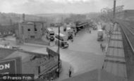
Barnsley Bus Station 1955
This photo is taken from the old Court House Railway Station at the bottom of Regent Street, the only railway station in this country to have that name. There was a stone viaduct following this plate girder bridge, entrance ...Read more
A memory of Barnsley by
From My Mother
My mother often spoke fondly of living in Bearpark from 1920 -1926 when the family came down to London. My grandfather, Edward Leadbitter, was a miner at Bearpark pit. He worked on an 18 inch seam, lying in water in the semi darkness ...Read more
A memory of Bearpark by
Portmanmoor Road Memories .
My nan used to own the florists at 28 Portmanmoor Rd - Mrs. Cox . Next door Mrs.White had a shoe shop . Her son was Tony White . Further on down Portmanmoor Rd was Canns - a hardware shop . Opposite was Edna Stones fruit and veg. ...Read more
A memory of Splott by
1966 70
I used to keep my ponies in a field opposite the Mill which was still working in a small way. I remember the dreadful flooding of 1968. We had to walk down Mill Lane to get to check the ponies. It was waist deep in water and when we got to the ...Read more
A memory of Sindlesham
Southall Town 50's 60's 70's 80's
Between 1950 - 1980's the family owned a bakers shop at 84 High Street. P.G.WOODFORD & SON (opposite the Police Station). If anyone has memories of this period it would be good to get in touch. I ...Read more
A memory of Southall by
Growing Up In Mount
We moved to Mount 1962, I started school at Darran Las Infant School. Then moved on to the Comprehensive. How big it looked and the kids where so grown up. The grounds where just beautiful and the old house was incredible. The ...Read more
A memory of Mountain Ash by
Old Shard End
My family moved to Shard End in 1951 to 11 Freasley Road. The estate was in its first stages then, no shops and no bus service, it was a walk to Lea village for the bus across the old bailey bridge. There was a lot of open ground in those ...Read more
A memory of Shard End by
Captions
1,770 captions found. Showing results 1,561 to 1,584.

There are ornamental flower beds amid grass between the walks and The Embankment road, which curves away from the river to accommodate the park before coming closer to the river near the

The buildings on Vines Corner to the left of the bridge have gone, while Swan House to the left of Holland's dignified Swan Hotel replaced the house and shops seen in photograph number B511054; they were

A car is a blur compared with the cycle and horses it is overtaking.

The town's Parks and Gardens department is justifiably proud of its long record of good husbandry in the Embankment Gardens.

Besides the vast acreage of excavated docks, there were numerous riverside wharfs, from the grandeur of Hay's Wharf near London Bridge to this rather less grand one near the west entrance to the Royal

It is used regularly today for sporting activities, and creates a green avenue through the town to the Hockley Bridge.

On the River Bure, Coltishall is a picturesque place and an important centre for building the famous Norfolk wherry.

Here we see the bridge over the River Greta in the busy little market town of Keswick in the northern Lakes.

This side of the castle was defended by a moat; there was once a drawbridge where the steps and stone bridge appear in this picture.

In the era of the stage coach, the George Hotel was classed as the best hotel on the Great North Road, and it is still one of the best in the area.

We are looking northwards to the junction of lanes leading to Bullhill (left) and Alderholt Bridge in the other direction.
In the era of the stage coach, the George Hotel was classed as the best hotel on the Great North Road, and it is still one of the best in the area.

The church and a cluster of old houses are at the top of the hill, and more old buildings are on the river bank, east and west of the Bognor Road river bridge.

Boroughbridge dates back to Norman times, when a bridge was constructed over the River Ure. In 1322 the Earl of Lancaster sought refuge in the local church following his defeat by Edward II.

Higher Mill stood midway between Jericho (centre) and Horn Bridge.

With a history stretching back to the Romans, and a short period as a 19th-century spa, Ilkley's situation on the edge of the famous Ilkley Moor was always its greatest asset.

Bridge Street is one of the main streets of the city of Chester, and still follows the original street plan laid down by the Romans.

Its name was originally 'Eadhelm's bridge', so the River Eden is named from this crossing point and not the other way around.

Long Bridge arrives from the right.

The Chesterfield Canal, the Mother Drain and the River Idle all reach the River Trent at West Stockwith - the canal is the most southerly of the three.

This view is in Homefield Park north-east of Steyne Gardens, and looks towards the Homefield Road gate; the chimney of No 42, one of the road's 1880s houses, can be seen between the trees and Thurlow

Then, in 1879, William Rock, a local man who went to London and made a fortune, returned home to improve Barnstaple.

Highway improvements have swept away the Italianate and balustraded mid 19th-century buildings in front of the spire, which is that of St Paul's Church. At the far right is the Swan Hotel.

Since the early 1700s the Avon has been divided into two halves at Evesham – the Upper and Lower – which are owned and managed separately.
Places (17)
Photos (40)
Memories (1928)
Books (2)
Maps (520)

