

Places
Sorry, no places were found that related to your search.
Photos
134 photos found. Showing results 161 to 134.
Maps
896 maps found.


Books
4 books found. Showing results 193 to 4.
Memories
542 memories found. Showing results 81 to 90.
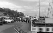
Western Esplanade, Alexandra Y.C. Dinghy Park. A Post Ww2 Facility.
As the classic 18ft long local dayboat classes became more expensive to build and maintain, there was an explosion of smaller, cheaper racing dinghy classes all round the UK, postWW2. ...Read more
A memory of Southend-on-Sea by
Looking Westwards, Towards Thorpe Hall Boulevard Junction With The Esplanade.
In 2014, across the road there are tennis courts, and from Google Earth it looks like a thriving Sports Centre. If there were tennis courts on that site in 1963, hardly ...Read more
A memory of Thorpe Bay by
Looking Westwards, Towards Thorpe Hall Boulevard Junction With The Esplanade.
In 2014, across the road there are tennis courts, and from Google Earth it looks like a thriving Sports Centre. If there were tennis courts on that site in 1963, hardly ...Read more
A memory of Thorpe Bay by
My Golden Years At Stokes Bay
I was born in Gosport in 1929, my father was a long serving seaman in the Royal Navy and so our family life was all things navy - so Stokes Bay was a big part of our lives. I had three elder sisters who were frequently ...Read more
A memory of Stokes Bay by
Best Childhood Ever
I was born in Easington Coliery in December 1940. Grew up in Canada In Dene Avenue. My dad worked At the pit as a wagonwayman in the Hutton Seam. Grandparents were from Cornwall Stret, East.I had a tha best childhood ever. ...Read more
A memory of Easington Colliery by
Researching My Family In Pembroke Dock
As a six year old in 1949 I was taken to Pembroke Dock to visit my Grandparents, from whom we were almost estranged. My only memory of the visit is looking out of the upstairs window above their butcher’s shop ...Read more
A memory of Pembroke Dock by
Northwood Road & Swalecliffe
My mother was 19 when I was born. We were living above The Wool Shop in Swalecliffe, on the corner, opposite the railway bridge I actually have an uncanny memory of that time. I must have been under 2 years old, as we moved ...Read more
A memory of Whitstable by
May And Baker (Dagenham East)
The May and Baker factory, close to the railway station at Dagenham East was once one of the largest factories in the area. The company was best known for developing the drug quinine to combat malaria, often simply referred ...Read more
A memory of Dagenham by
Bradford House
My daughters and I lived happily at Bradford House for seven years in the late 1990's ... The house was originally two 17th century cottages at right angles to each other. The Victorians then re-modelled one of the cottages, ...Read more
A memory of Bradford-on-Tone by
Ww11 Factory, Llanfaes.
If you walk North along the beach from Beaumaris to Llangoed you pass both the old lifeboat station & you will see some large buildings to the left, (on the right in this photo, just after the road junction) on the other side ...Read more
A memory of Llangoed by
Captions
870 captions found. Showing results 193 to 216.

This pleasant stone-built Victorian seaside resort clusters beneath the steep craggy slopes of the coastal mountains on Conwy Bay, and looks across the broad eastern approaches of the Menai Strait to Anglesey

Just below the promenade and overlooked by some prominent hotels, these visitors enjoy a sunny day. The

Sandown and its twin resort of Shanklin, a couple of miles to the south, are connected by a long promenade that winds around the curve of Shanklin Bay. This

Here we see the view southwards along South Street, from the taxi rank (left) to the tower of St Mary's Parish Church (right of centre). This was the B3157 to West Bay and Burton Bradstock.

Bathing is possible along some of the beaches at Cowes, particularly at Gurnard Bay. However, the currents are strong and the shoreline shelves steeply.

High tide in the Basin, looking eastwards to St John's Church (left of centre), West Bay Hotel (centre), the Custom House (right of centre) and Old Storehouse (further right).

For decades, just as in this picture, people have sun bathed along the sea wall.

In the shadow of St Mary`s church, Hotel Mariners on the right was established in 1625. The building to the centre is now without its bay window.

The modest hotel stands on North Quay Hill with a view over the harbour and bay. An almost colonial-style veranda with fancy railings is supported on cast-iron pillars with a twisted decoration.

Westbourne, on the west side of Bournemouth, retains a village atmosphere even today, with spacious houses and hotels situated around an attractive woodland chine leading down to the sea.

The fishing village of Runswick Bay is set on a sheer cliff. It is also one of the most attractive harbourless villages along the Yorkshire coast.

Here we have another view of North Landing, showing the brick-built lifeboat house.

The coat of arms above the North Gate is that of James ll. Parking is beginning to present a problem.

Whalers, fishermen and smugglers were once regular visitors to the bay. Erosion has always been a problem here. In 1682, a landslide destroyed every dwelling except one.
The coat of arms above the High Street Gate is that of James ll.

East Runton offered visitors the same spectacular cliff scenery and ample beaches as its close neighbour, Cromer, but less of the noise and bustle.
Sandy Bay is Littleham's beach, offering some of the finest bathing on the East Devon coast.

The north aisle wall was moved when the aisle was widened in 1846, but the Norman arcades remain; they have three bays, with unmoulded arches of simple imposts with slight chamfering.

What an ideal way to spend a relaxing afternoon. A gentleman with a fishing line tries his luck in the ocean, while the children search the seaweed-covered rocks for anything they can find.

This view, taken from Stonecot Hill, shows the 1930s Woodstock pub, which still flourishes.

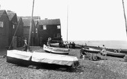
The little concrete pier affords some protection to the fishing boats at Portscatho, although it is barely a harbour. Nare Head and the Gull Rock can be seen across Gerrans Bay.

A long line of rowing boats waiting for their customers stretch around the bay at Waterhead, near Ambleside. In the distance, Todd Crag and Loughrigg Fell fill in the left background.

The church is an elegant creation of around 1300, with a tall, slim five-bay arcade and clerestorey, creating a tremendous feeling of space.

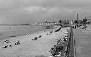
From the bottom of Valley Road the camera captures a crowded South Beach scene, and a bay full of sail-driven fishing boats.
Places (0)
Photos (134)
Memories (542)
Books (4)
Maps (896)

