

Places
36 places found.
Did you mean: street or streetly ?
Those places high-lighted have photos. All locations may have maps, books and memories.
- Heathfield, Sussex (near Cade Street)
- Street, Somerset
- Chester-Le-Street, Durham
- Adwick Le Street, Yorkshire
- Scotch Street, County Armagh
- Friday Street, Surrey
- Potter Street, Essex
- Boughton Street, Kent
- Newgate Street, Hertfordshire
- Streetly, West Midlands
- Shalmsford Street, Kent
- Green Street Green, Greater London
- Boreham Street, Sussex
- Park Street, Hertfordshire
- Cade Street, Sussex
- Appleton-le-Street, Yorkshire
- Hare Street, Hertfordshire (near Buntingford)
- Romney Street, Kent
- Trimley Lower Street, Suffolk
- Streetly End, Cambridgeshire
- Hare Street, Hertfordshire (near Stevenage)
- Brandish Street, Somerset
- Colney Street, Hertfordshire
- Langley Street, Norfolk
- Silver Street, Somerset (near Street)
- Street, Yorkshire (near Glaisdale)
- Street, Lancashire
- Street, Devon
- Street, Cumbria (near Orton)
- Street, Somerset (near Chard)
- Bird Street, Suffolk
- Black Street, Suffolk
- Ash Street, Suffolk
- Broad Street, Wiltshire
- Brome Street, Suffolk
- Penn Street, Buckinghamshire
Photos
24,921 photos found. Showing results 221 to 240.


Your search returned a large number of results. Please try to refine your search further.
Maps
1,622 maps found.


Books
3 books found. Showing results 265 to 3.
Memories
6,667 memories found. Showing results 111 to 120.
The Howard Family Of Barnes And Hammersmith
My Great-Great-Grandad, Henry Howard, lived in the early 1800’s - a time of great rural depression - and so he left his Devon home to look for work in London with the result that several generations of my ...Read more
A memory of Barnes in 1870 by
Madeley As It Was
I was born in 1949 in Victoria Road, Madeley and have many memories of life as it was in the 1950's onwards. I remember Jones' buses, Pooles the cobblers, Carters, Stodd's the Drapers, Shums the chemist, and most ...Read more
A memory of Madeley in 1949 by
Lockwood Beck And Lingdale
Hi Everyone what a lovely photo of the reservoir. My family lived at the reservoir for many years. My father and his father were born there with his sisters. He was Henry Marshall born 1923. He was the 3rd Henry ...Read more
A memory of Boosbeck by
Meeting Street
I have a copy of the Meeting Street photo as the girl standing in the road (with the black sleeve) is my Grandmother SARAH POWE (nee Lesley). The family house was at 29 Meeting Street just out of view. Grandmother also ran the BELL ...Read more
A memory of Appledore by
Where I Lived In 1960
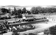
We moved into the flat above Snodland station on 9th January 1960 (my 8th birthday) and the extreme left upstairs window was the view from our lounge (or, rather - sitting room). I attended Brook Street CoE Primary school from ...Read more
A memory of Snodland in 1960 by
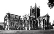
An Unappreciated History
When you grow up in an ancient city such as Hereford and have really no other frame of reference you don't fully grasp the enormity of the depth of history that buildings such as Hereford Cathedral embodied. The Romans built ...Read more
A memory of Hereford in 1957 by
End Of An Era
In 1944 I was a 13 year old pupil at Morley Grammar School. One beautifully sunny Sunday evening I walked from my house at 16 Albion Street (now Morrison's carpark) and about 40 yards East of the Pentecostal Church of the Nazarene (since ...Read more
A memory of Morley in 1944 by
Stratfield Mortimer, C1955
The entrance on the left is to Mortimer Station and the house (red brick) just right of centre is the Old Post Office. The white house just left of centre is Street House. The building to the right (and slightly closer to the foreground) is the old water pumping station.
A memory of Stratfield Mortimer in 2008 by
On Our Way To Longleat.....
After walking the footpath from Rodden Farm we would end up on the main Frome /Warminster road, not far from the start of Friggle Street. This was our route to Longleat we often took on foot during our school holidays. We ...Read more
A memory of Elliots Green in 1980 by
Busk Crescent
Late in 1945 my parents moved to 25 Busk Crescent, in Cove. The house was on top of a hill and overlooked the Farnborough airfield. From the front bedroom you could see aircraft landing on the runway. The house was one of a string of ...Read more
A memory of Cove in 1945 by
Captions
5,435 captions found. Showing results 265 to 288.

In Nether Stowey, you are in Samuel Taylor Coleridge country: he rented a cottage in Lime Street from 1796; whilst here, he wrote 'The Ancient Mariner' and 'Kubla Khan', the latter famously interrupted

The seaward end of Broad Street was once the hub of Lyme Regis with its old Custom House, until a devastating fire in 1844.

Hodges Garage (in the distance, behind the bus entering Market Square) has since been demolished, and the Castle Hotel (by the street lamp on the right) has also closed.

A busy late morning scene in Colchester's High Street at the turn of the century.The Town Hall, which dominates this view, was not completed until 1902.The High Street lies along the central axis

Further 'up street' we now meet the junction of Westgate with Chaloner Street, which leads off to the right.

Cockburn Street twists and climbs up to the High Street. On the right, the famous crown spire of St Giles's Church can be seen above the rooftops.

The narrow ancient streets of Harlech, a town that sprang up to serve the stronghold, have changed little over the years, as is shown by this picture of the High Street.

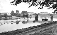
Here we see the 13th-century Buddle Bridge (centre) and the buildings of Bridge Street which crossed it until demolitions for road widening in 1913.

This view down Silver Street, widened here at the junction with Gold Street in the 1930s, looks towards Dalkieth Place.

This photograph was taken looking north up the High Street. To the left is Market Street, now pedestrianised, to the right is Blenheim Road, and behind the photographer is the park.

Pound Street continues south-west from Hiugh Street; it is more cottagey, apart from two grander houses on the left. The street is little altered, apart from more formal pavements and roadway.

This view looks along the north side of Market Square past the war memorial into Cambridge Street on the left of the Round House and the High Street to its right.

As we turn our back on the Market Square, High Street runs westward to Sheaf Street.
This view down Silver Street, widened here at the junction with Gold Street in the 1930s, looks towards Dalkieth Place.

Lord Street was built as a boulevard shopping street with fine canopied pavements - a place to see and be seen - and it is still an aspirational goal for many national retail chain stores.

The local Board of Health had put their foot down over the amount of debris that the market was depositing in the High Street every Friday. It was February 1880 when the new site opened.

The brick-built Congregational church on the corner of Union Street and King Street was opened in 1912 and still flourishes, now as the United Reformed Church.
At the town centre, then as now, was the Market Square, mostly lying on the east side of the main street.

Thompson Street was the most important link from Barry Docks to Holton Road.

This view looks west along Church Street. The building on the left was the old grammar school, and is now a solicitor's office.

Robert Dyas's long narrow shop had frontages on both High Street and Baker Street.

This was in the days when supermarkets complemented high street shopping. Out of town shopping and subsequently deserted high streets were still some way off in the future.

An early experiment using water-carts to damp down the streets found that it took 7,000 gallons to water one mile of street, 18 feet in width, at a cost of 8s 4d per mile.

Because Egremont was a newly-laid-out town, the streets were mostly straight and wide. King Street ran parallel to the Promenade, and was a very busy thoroughfare.
Places (385)
Photos (24921)
Memories (6667)
Books (3)
Maps (1622)

