

Places
36 places found.
Did you mean: street or streetly ?
Those places high-lighted have photos. All locations may have maps, books and memories.
- Heathfield, Sussex (near Cade Street)
- Street, Somerset
- Chester-Le-Street, Durham
- Adwick Le Street, Yorkshire
- Scotch Street, County Armagh
- Friday Street, Surrey
- Potter Street, Essex
- Boughton Street, Kent
- Newgate Street, Hertfordshire
- Streetly, West Midlands
- Shalmsford Street, Kent
- Green Street Green, Greater London
- Boreham Street, Sussex
- Park Street, Hertfordshire
- Cade Street, Sussex
- Appleton-le-Street, Yorkshire
- Hare Street, Hertfordshire (near Buntingford)
- Romney Street, Kent
- Trimley Lower Street, Suffolk
- Streetly End, Cambridgeshire
- Hare Street, Hertfordshire (near Stevenage)
- Brandish Street, Somerset
- Colney Street, Hertfordshire
- Langley Street, Norfolk
- Silver Street, Somerset (near Street)
- Street, Yorkshire (near Glaisdale)
- Street, Lancashire
- Street, Devon
- Street, Cumbria (near Orton)
- Street, Somerset (near Chard)
- Bird Street, Suffolk
- Black Street, Suffolk
- Ash Street, Suffolk
- Broad Street, Wiltshire
- Brome Street, Suffolk
- Penn Street, Buckinghamshire
Photos
24,921 photos found. Showing results 2,681 to 2,700.


, Corn Exchange, Corn Street 2005, Bristol")
, Corn Exchange, Corn Street 2005, Bristol")
, Corn Exchange, Corn Street 2005, Bristol")
, Corn Exchange, Corn Street 2005, Bristol")


Your search returned a large number of results. Please try to refine your search further.
Maps
1,622 maps found.
Books
3 books found. Showing results 3,217 to 3.
Memories
6,667 memories found. Showing results 1,341 to 1,350.
Arthur Shackson And His Wife Gertie With Their Son Arthur.
This is my Uncle and Aunt and cousin Arthur, outside their cottage no. 32 North Hill in Clovelly village. They lived there for many years and took in many many people for B&B, people ...Read more
A memory of Clovelly by
The War Years In Consett
I was born in Consett at 11 Newmarket Street in June 1933, though my parents were living in Norfolk and later on in Middlesex. I was sent back to live with aunts when the Blitz really got going. I went to the CofE Primary ...Read more
A memory of Consett in 1940 by
Search
Hi, can anyone out there in Hull remember the Webster family from Cumberland Street? The dad was a bargee, there were quite a lot of kids. Please answer via this site, I would love to know more about them.
A memory of Kingston upon Hull by
Seems Like Yesterday
Hi! I was born in Meir 1934,and all my mother's family lived in Longton (Worsdale). My Uncle Frank had "The Studio" pub in Commerce Street, and, later, "The Studio Snackery". I've lots of great memories of Smith's Crisps,and ...Read more
A memory of Longton in 1940 by
Ogmore Vale
Goodness! Reading all these wonderful memories of others living in Ogmore, reminds me of mine ... I remember visiting the Workmen's Hall cinema and all the 'old' movies - Dambusters, Jerry Lewis & Dean Martin! - how strange that ...Read more
A memory of Ogmore Vale in 1955
Glendale Avenue
I lived at 2 Glendale Avenue with my mam and dad, Martin and Peggy, and my two sisters, Margaret and Maureen, and my brother Martin. My grandparents lived at number 10 Glendale. My earliest memories revolve around playing in the ...Read more
A memory of Bebside in 1962 by
The Peculiar People's Chapel
Mark Pierson (hello Mark - we know each other) suggests the Peculiar People's chapel was in the Street - but it was definitely situated at Hawbush Green, at least during my early childhood in the Fifties. I distinctly ...Read more
A memory of Cressing by
Dark Days Of The Second World War
Those foggy days in Dartford and the oil tanks on the street corners that produced a lot of smoke that was designed to send smoke into the atmosphere so that enemy planes could not get a visionary view of the area ...Read more
A memory of Dartford by
My First 9 Years
I love my home town of Dorking. I was born there in Lincoln Road in July 1939, five weeks before the start of WW2. We played in the street and used people's gate posts for rounders bases as there was not a car in sight. We roamed ...Read more
A memory of Dorking in 1945 by
Salmon Street
Salmon Street was where I was born, and Kingsdown was where my family lived for at least 140 years. Salmon Street Walk Ler Street never changed that is until the Second World War when we were well and truly bombed. There is so much to say about Kingsdown, too much to put in this small space.
A memory of Kingsdown in 1930
Captions
5,435 captions found. Showing results 3,217 to 3,240.

The eastern side of the street was mainly occupied by shops, while the opposite side was mainly made up of offices, both municipal and business.

The High Street extends westwards from the River Stor to the triangular market place (in the foreground), which was established by 1399.

The tall poles in the street indicate the advancements in communication technology made that year by the nearby Medway Telephone Exchange.

This splendid view of the High Street as it ascends the hill towards the Guildhall was taken from the Town Bridge crossing the River Wey.

Frith's photographer was looking back through the carriageway towards Church Street straight ahead.

Frith's photographer was looking back through the carriageway towards Church Street straight ahead.

Erected in 1858 as a memorial to Robert Peel, the Town Hall, whose porch and balcony project into the street, originally served as the Mechanics' Institute until the town was incorporated as a borough

When this picture of the High Street was taken, there would be plenty of outlets from which it was possible to buy tobacco products.

The inn's name moved here from Hill Street in the 1840s.
A quarter of a century apart, this and the previous view of the High Street show how little it changed throughout the 20th century, with the exception of traffic problems and an increased number

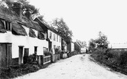
Village Street leads away downhill to the old post office.

This one-street town is one of the most delightful in England; it is a special place to visit and an even better one to stay in, to use as a base for the exploration of Worcestershire.

No motor vehicles are allowed in its steep cobbled streets, and what we see today is essentially what our cameraman saw in 1930.

There is now plenty of traffic on the street. A sign in the middle of the row of buildings on the left is for the library.

Further west along Main Street, looking towards Lyme Regis, the plateau of Langdon Hill forms the skyline (centre). The cart is beside Rose Cottage and Foss Cottage (left).

Here we see some horse-drawn carriages, including a street cleaner's cart, parked outside the Parish Church of St John Baptist.

Dominant in this photograph of the east end of the High Street is the Town Hall, which at the date of this photograph had just been rebuilt by local architect C E Ponting.

Not something that would happen today with any degree of safety, a gentleman poses for the camera in the middle of the street.

The church of St Peter occupies an island site where the main street divides.

This street has become estate agents' row - at Nos 4, 14, 18a and 24 Chalet Hill that is just what you will find.

The house on the corner of Montrose Street to the left is now another medical centre, with a dental surgery next door.

Horbury, three miles south-west of Wakefield, was once one of the busiest railway junctions in the country; hence, perhaps, the absence of any form of traffic in the High Street in this photograph.

This is Georgian urban architecture and townscape at its best, and our route starts in Queen Square, west of Milsom Street.

Heading north-east out of Bath on the A4, cross the A46 junction onto the old A4, which soon becomes Batheaston High Street.
Places (385)
Photos (24921)
Memories (6667)
Books (3)
Maps (1622)

