

Places
36 places found.
Did you mean: street or streetly ?
Those places high-lighted have photos. All locations may have maps, books and memories.
- Heathfield, Sussex (near Cade Street)
- Street, Somerset
- Chester-Le-Street, Durham
- Adwick Le Street, Yorkshire
- Scotch Street, County Armagh
- Friday Street, Surrey
- Potter Street, Essex
- Boughton Street, Kent
- Newgate Street, Hertfordshire
- Streetly, West Midlands
- Shalmsford Street, Kent
- Green Street Green, Greater London
- Boreham Street, Sussex
- Park Street, Hertfordshire
- Cade Street, Sussex
- Appleton-le-Street, Yorkshire
- Hare Street, Hertfordshire (near Buntingford)
- Romney Street, Kent
- Trimley Lower Street, Suffolk
- Streetly End, Cambridgeshire
- Hare Street, Hertfordshire (near Stevenage)
- Brandish Street, Somerset
- Colney Street, Hertfordshire
- Langley Street, Norfolk
- Silver Street, Somerset (near Street)
- Street, Yorkshire (near Glaisdale)
- Street, Lancashire
- Street, Devon
- Street, Cumbria (near Orton)
- Street, Somerset (near Chard)
- Bird Street, Suffolk
- Black Street, Suffolk
- Ash Street, Suffolk
- Broad Street, Wiltshire
- Brome Street, Suffolk
- Penn Street, Buckinghamshire
Photos
24,921 photos found. Showing results 1,121 to 1,140.


Your search returned a large number of results. Please try to refine your search further.
Maps
1,622 maps found.


Books
3 books found. Showing results 1,345 to 3.
Memories
6,667 memories found. Showing results 561 to 570.
Kathryn Trevelyan Nee Bennett.
I remember the houses opposite St.Theodore's as my cousin Veronica (Non) lived in one and the "Turners" (Pat, Shirley, Roy and others) lived next door. These houses had front doors in Higher Church St, while the back ...Read more
A memory of Pontycymer in 1964 by
Mossband Camp
My father was a serving soldier, serving at the RAOC camp until 1948. We lived in the YMCA building in the camp itself and it had a large functions hall attached where one of our officers once entertained the children at Christmas ...Read more
A memory of Mossband Ho in 1947 by
Drake Street
I was born in Rochdale in 1934. I attended Champness Hall Sunday School, 1940 -52, which was situated just below the Rochdale Observer offices (on the left of the photo). It was a large Methodist Central Hall with offices used by local ...Read more
A memory of Rochdale in 1952 by
My Birth Place
I was born in Templecombe Hospital on 13 April 1943, my mother was Lilian Game (nee Atkins) and was staying with her widowed father, Ernest Atkins of Silver Street, Wincanton, after leaving London because of the bombing during the war. My brother was also born there in September 1944.
A memory of Templecombe in 1943 by
Penzance Market Jew Street
As a boy I must have walked up and down Market Jew Street hundreds of times. In particular I along with friends would visit the local Woolworth's where we liked to partake of various flavoured "Milk Shakes" Later during ...Read more
A memory of Penzance in 1940 by
Mobo Horses
We moved to Prestatyn in 1948. I loved the Mobo horses that the little ones could ride at the Bastion Road beach. My little school was Pendre, up the hill Fforddlas I think. Also going to St Chad's School annual fair and sale. Always ...Read more
A memory of Prestatyn in 1950 by
Slag Heaps
I was born in Birks Road, Cleator Moor in 1954. I was from a large family called Sheldrake. We lived over the railway bridge towards the brewery. The neighbours that I know of are: the Watsons, the Moors, the Wrights, the Richardsons, ...Read more
A memory of Cleator Moor in 1954 by
Re Tony Bros Ice Cream
I remember Tony Bros ice cream parlour off Acton High Street. On some Sundays my father would take me for a treat for a cornet or wafer scooped out of the big drum on the counter, it was always after giving our dog Sally ...Read more
A memory of South Harefield by
War Years
We lived first in Vinson Close, then in Glencorse in the High Street, next door to the Commodore. My friends included Eric Cox, who lived opposite in a flat over the undertaker's; Les Forrow, whose father was manager of a grocer's shop ...Read more
A memory of Orpington in 1940 by
Priory Road 1962 To 1988
My father, William J Smith (Bill) had a newsagent at 47 Priory Road between 1962 and 1988 which was opposite Ports the Bakers. I remember seeing queues of people coming out of the Bakers on a Saturday morning to get their ...Read more
A memory of South Park in 1970 by
Captions
5,435 captions found. Showing results 1,345 to 1,368.

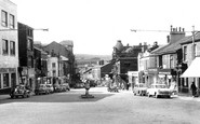
This broad street, with ample space for parking, displays contrasting architectural styles: the small 19th-century shops face mid 20th-century designs.

The name of the street harks back to the days of the medieval walled town. The gate itself was demolished in 1781.

Looking west along the High Street, we see buildings which are characteristic of North Norfolk: flints set in mortar, with brick facings.

This road is still open to Westgate Street and has two-way traffic. The balconies on the hospital were added in 1908.

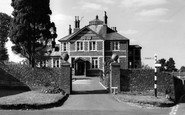
The road to the right leads to the railway station, but directly along the leafy street is The Spa, a particularly popular hydro.

This picturesque view of the High Street is flanked by the Methodist chapel on the left-hand side, now converted into residential units.

This view of the High Street shows many buildings that have either since disap- peared or have been radi- cally reworked.

John Bunyan was born in Elstow, and lived in a cottage on Elstow High Street for four years after marrying his first wife.

Note the deep gully in the street. This was for rainwater drainage, and would also have carried off waste water from fish cellars.

This view of the Poultry Cross and Silver Street clearly shows a sign over Olivers' shoe shop.The County Hotel is in the background.

This view of the Poultry Cross and Silver Street clearly shows a sign over Olivers' shoe shop.The County Hotel is in the background.

Note the broad width of the street where the market used to be held, and the pleasing variety of architecture and raised pavements.

Further right is the entrance to Fish Street.
The road to the right leads to the railway station, but directly along the leafy street is The Spa, a particularly popular hydro.

Street gaslighting was introduced into the city in March 1824, replacing earlier oil lamps.
Houses were built on most of the remaining available land - this was mainly between Park Road and Sandy Lane; to the north and south of the High Street; and along Fairfax Road.

D E Baker's department store (extreme left) flanks the entry to Church Street from the Market Place; the road was very much narrower than today, following the road widening scheme and demolition

colourful, bustling scene, loud with the cries of the market-traders, the rumble of cartwheels over cobbles, the barking of dogs and the shouts and laughter of children chasing through the crowded streets

St Mary's church dominates the High Street skyline. Unique in Hertfordshire, Standon parish church has a detached bell tower and a porch at the west end rather than on the south wall.

Apart from bus stops, street lamps and motor cars, little else seems to have changed for perhaps half a century or more.

The High Street used to be the main Norwich to London road. Here is a foretaste of the traffic problems that were to come.
Street gaslighting was introduced into the city in March 1824, replacing earlier oil lamps.

We are looking downhill to where the High Street divides; it continues on as the right-hand fork. The lack of traffic is quite remarkable.

This is Park Street in the days before the top end was dominated by the Gothic tower of the university, designed by Sir George Oatley.
Places (385)
Photos (24921)
Memories (6667)
Books (3)
Maps (1622)

