Merry Christmas & Happy New Year!
Christmas Deliveries: If you placed an order on or before midday on Friday 19th December for Christmas delivery it was despatched before the Royal Mail or Parcel Force deadline and therefore should be received in time for Christmas. Orders placed after midday on Friday 19th December will be delivered in the New Year.
Please Note: Our offices and factory are now closed until Monday 5th January when we will be pleased to deal with any queries that have arisen during the holiday period.
During the holiday our Gift Cards may still be ordered for any last minute orders and will be sent automatically by email direct to your recipient - see here: Gift Cards
Places
Sorry, no places were found that related to your search.
Photos
Sorry, no photos were found that related to your search.
Maps
7,034 maps found.


Books
163 books found. Showing results 4,537 to 4,560.
Memories
22,913 memories found. Showing results 1,891 to 1,900.
Australians On The Cut 1975
Having left Australia on an open-ended working holiday to England in January, 1974 with my girlfriend, it was hard to imagine that within six weeks of arriving in London we'd be living on a leaky old narrow boat in ...Read more
A memory of Leighton Buzzard in 1975 by
A Wonderful Time
My family and I lived at 157 Wilmslow Road, it had just been built so all of us who lived on the road moved in around the same time, and it was a wonderful. My parents George and Thelma Goddard, had the three of us then, Georgina, ...Read more
A memory of Handforth in 1955 by
Born In Ilford
Ilford Town Hall is on the corner of Oakfield Road where I lived throughout WW2. The public Air Raid Shelter we used to sleep in was opposite the Town Hall in Oakfield Road. A very large department store called Moultons was opposite, in ...Read more
A memory of Ilford in 1940 by
Not Uplyme Mill
The picture titled "Uplyme Mill 1892" is incorrect. The location is Lyme Regis and is called Higher Mill along the banks of the River Lym in an area known as "Monkeys Rough" locally, opposite the original "Jericho" and "Paradise ...Read more
A memory of Lyme Regis in 1890 by
Holmwood School Pupil.
I have many memories of my time at Holmwood School. I joined as a day boy in 1968, when the Headmaster was David Glass and I left around 1973 when the Headmaster was Johnny Clegg. I remember the trips we had in the old school bus ...Read more
A memory of Formby in 1968 by
Eric Smith''''s Greengrocer''''s 21 Lordship Lane Se22
My Dad, Eric Smith, opened a Greengrocer's shop at number 21 Lordship Lane in 1962. At that time there was a traditional butchers shop one side and a grocery shop the other side. Opposite was a piano ...Read more
A memory of Dulwich in 1962 by
Where I Lived
This is where I lived between 1966-1984,above the Read Brothers newsagent in Hall Road,there is only two shops there now,one is still the newsagent and the other is closed at the moment,the rest of the six shops are now flats for the disabled.
A memory of Aveley in 1970 by
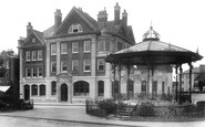
This Was A New Building When The Picture Was Taken
It was built in 1897 and was designed in the Queen Anne style by the architect Frederick Wheeler FRIBA who had offices in Horsham. It is now the home of the Nat West bank. The bandstand has been moved ...Read more
A memory of Horsham in 1890 by
Is This The Causeway
It does not look like the Causeway to me. At the time of the photos, 1898, this road was fully populated with the exception of the Vicarage Garden. The photo shows open field so is perhaps one of the lanes leading up to Denne Park, beyond the Causeway or Denne Road.
A memory of Horsham by
Not Changed Over The Years!
You can compare this image to an up to date photo at http://www.hiddenhorsham.co.uk/hh/frith3.htm
A memory of Horsham by
Your search returned a large number of results. Please try to refine your search further.
Captions
9,654 captions found. Showing results 4,537 to 4,560.

This crossroads west of the village of Calver is known as Calver Sough - a sough (pronounced “suff”) being a drainage tunnel designed to take water out of lead mines.

At the centre of the village is the ancient market cross and priory gatehouse, now owned by the National Trust.

Well before it became a favourite bathing and picnic spot, the Lune's beauties at Caton were extolled by the poets Wordsworth and Gray, and Turner came to paint the scene.

Sharing its name with the river in whose valley it lies, Darwen grew rapidly as a result of industrialisation in the early 19th century, and many of the buildings along Market Street were

It was planned that each neighbourhood in the New Town would have its own pub.

Hanbury sprawls along the B4091, which runs north from the Saltway to Bromsgrove.

Most of Alcester Street was demolished in the 1960s, but this small part of it survived.

This detail from R84017 (page 40) provides a close-up view of the former home of the Redditch Benefit Building Society.

The foundation stone was laid in October 1954 by the late Princess Margaret and blessed by the Lord Bishop of St Albans.

Close to the village of Nettleden is one of the most beautiful places in the county.

It was intended to mirror a building on the opposite corner, but the project was never pursued.

Today Martin's Bank (centre left) is occupied by an estate agent, reflecting Lymm's status as a housing hot spot, whilst Barclay's Bank (centre) trades from a less harmonious modern building.

Built in 1561 in the reign of Queen Elizabeth I, the half-timbered Barley Mow Inn is the one constant factor in Warrington's old Market Place.

The two shops on the left were both Morley's, one a clockmaker's, the other an ironmonger's. The tree is at the east end of the churchyard.

The Orange Tea Rooms (we can see the projecting sign) is now a florist, and the slate-hung shop on the right, in this picture Miss Whitford's, selling pots and pans, china, paraffin and other useful items

This view shows the backs of buildings along Kempock Street. Kempock Place is just in view on the extreme left of the picture.

THE ACT OF UNION in 1707 was bitterly reviled at the time, and even for many years afterwards - Robert Burns echoed popular sentiment when he dismissed the Scottish commissioners with the lines

Chasewater is a large reservoir with an amusement park at its southern end, where people enjoy water sports such as sailing and water-skiing, or just paddling.

People mostly arrive at the Lickeys by car today (though there are plenty of buses), but from 1913 to 1924 they came by bus, and from 1924 to 1952 on the hugely popular Number 70 tram, which served

Stratford Road was first recorded in 1322, though it was just a trackway known as Shirley Street at that time. Shirley developed along it in linear fashion.

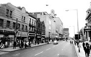
It is difficult to understand how such a structure could be allowed to replace decent Victorian shops, especially in a street where many of the buildings are listed, but it was probably a source

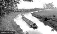
The young man resting his oars in the right-hand boat of the four boats on the left, wisely assesses the movements of the other craft before manoeuvring, taking account of their progress.

The Cotswolds reach their highest point at West Down, 1083 feet above sea level, above this parish of Cleeve Hill, east of Cheltenham.

St John in Bedwardine, to give it its full name, is a 12th-century church of considerable interest, despite Victorian alterations.
Places (0)
Photos (0)
Memories (22913)
Books (163)
Maps (7034)

