

Places
1 places found.
Those places high-lighted have photos. All locations may have maps, books and memories.
Photos
30 photos found. Showing results 41 to 30.
Maps
4 maps found.
Books
Sorry, no books were found that related to your search.
Memories
112 memories found. Showing results 21 to 30.
West Street
I was born in West Street in 1953 - my father was the manager at Lovibond's wine merchants. This photo is the closest to it. I remember the Black Horse, which was down the road from where we lived, and The Swan, which was half way up West ...Read more
A memory of Horsham
My Fenny Stratford Childhood
Having recently by chance spoken with someone who knew Fenny Stratford I was prompted to start looking on the internet and came across this site and for what it’s worth decided to record my memories. I was born in ...Read more
A memory of Fenny Stratford by
Hatch End 1960 1978
I lived in Derwent Ave and went Grimsdyke School .I remember Mrs Swan im sure she was a Dinner lady had a son called Nigel .Im trying to remember the head teacher she was a lady was in Miss Forsyth??I should remember i was outside ...Read more
A memory of Hatch End by
Fleshmarket Close
When I was 8 or 9 years old our family moved from Clyde Street, Edinburgh to the High Street or, as we called our immediate area, 'The Tron', in view of living in the shadow of the old Tron Kirk. Our address was 'Fleshmarket ...Read more
A memory of Edinburgh in 1953 by
A Walk From Wickford High Street Down The Rettendon Raod
My name is Kevin Mears, I lived in Wickford from my birth in 1958 until I got married in 1980. I shall describe my memories of Wickford in the 1960s and 1970s as a couple of walks around the ...Read more
A memory of Wickford by
Growing Up In Lea Road Southall
I lived in Lea Road, Southall. My father Alfred was a lorry driver for Sanders & Son, also known as The Tube, half way down Gordon Road. My mum Betty worked as a manager of Bill Taylors newsagents just off the ...Read more
A memory of Southall in 1968 by
Surrey St.
I have only just discovered this website and felt compelled to respond. I was born in Heathfield Gardens, South Croydon in 1948 and my maiden name was Murphy. We moved to Wyche Grove near the Purley Arms, South Croydon when I was about 5 ...Read more
A memory of Croydon by
Hillside Standon
My parents (Harold and Peggy Warden) bought Hillside (which was the miller's house, the mill fell down after the First World War) and moved my sister (Rosemary) and I from Surrey in April 1951, I was then 7 years old. Later that ...Read more
A memory of Standon in 1951 by
Broad Street
My Great Great Grandfather, Abraham Alexander Caddick was Landlord of the Swan Inn in Broad Street around 1900.
A memory of Blaenavon in 1890 by
Grandma Grandads House New Street
My grandma and grandad lived in New Street, Millbrook. I remember as a six-year-old going to see them and going to the 'swan pool' at the bottom of the road and feeding the swans. Grandma died in 1966 and Grandad ...Read more
A memory of Millbrook in 1965 by
Captions
72 captions found. Showing results 49 to 72.

This street takes its name from the Guildhall of Our Lady, later called the Wool Hall, which now forms part of the Swan Hotel on the left.

This view looks north along the High Street past the now 'improved' junction with West Lane.

At the west end of the High Street, London Road curves away north-west downhill.

In the centre of the picture, in Water Street, is Priory Farm, which once belonged to Earls Colne Priory in Essex.

The town-village grew up where the Roman Stane Street crossed the River Arun.

Boots the chemist had built their original store on the corner opposite the Royal Hotel at the bottom of Market Street.

East Street used to lead from the Common Acre past a number of big houses. On the right, three dormers mark the roof of the Manse to the Congregational Church, built in 1780.

This view looks down the High Street towards the clock tower. This was built as a market hall and lock up, or temporary prison, in 1842, but in 1870 the clocktower, belfry and spire were added.

The south-west side of Ware High Street changed drastically when it was decided to build a new Tesco Store in 1960.

Bridge House, the Post Office Stores and the adjoining houses (centre bottom) follow the curve of the street, named after The Swan Inn.

The White Swan beyond is still there, and next is another shoe shop, E C Hall. A young lady is in charge. Wold Antiques is next, and then comes a building that is looking sad and forlorn.

Attempts to make amends include pedestrianising the High Street, but many of the buildings seen in this view, particularly on the left- hand side, have gone, including the 1880s Barclays Bank
Boots the chemist had built their original store on the corner opposite the Royal Hotel at the bottom of Market Street.
The White Swan beyond is still there, and next is another shoe shop, E C Hall. A young lady is in charge. Wold Antiques is next, and then comes a building that is looking sad and forlorn.

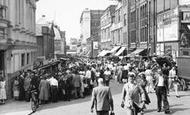
The High Street still has shops, banks and pubs. Petty Sessions were held in the Swan Hotel, and the public house on the right has been a popular watering-hole since the early 1800s.

East of the church and the Moot Hall, a jettied timber-framed building of about 1500, standing in its green, is the main north-south village road, the High Street.

The parish church of St Peter, with its solid flintstone tower dominating the high street shops and mid-morning traffic in this picture, was originally built by the Normans alongside the spacious

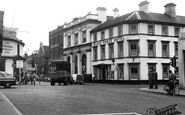
On the left, along West Street, stood the Crown and Anchor public house next door to the shop selling 'home-made pork pies and sandwiches'.

The Coln runs alongside the village street, where ducks waddle along the tops of low stone walls and spotted trout nose their way through the waving waterweeds.

The cenotaph in the High Street commemorates those who died in battle but whose remains lie elsewhere.

The staircase from Houghton House, carrying the date of 1688, is in the Swan Hotel at Bedford.

Those still trading are the Surrey Yeoman (see 46016 overleaf), the Bull's Head (Rose Hill, which we can see in 54666, right, with its entrance on the corner of the High Street and just behind the

Swain Street runs south from the harbour; it is narrow and mixed architecturally, as can be seen in this Edwardian view.

This view, from the east side of the harbour, looks across the Esplanade to the slipway at the junction of Market Street and Swain Street, the old core of the town.
Places (1)
Photos (30)
Memories (112)
Books (0)
Maps (4)

