

Places
7 places found.
Those places high-lighted have photos. All locations may have maps, books and memories.
Photos
264 photos found. Showing results 261 to 264.


Maps
28 maps found.
Books
Sorry, no books were found that related to your search.
Memories
357 memories found. Showing results 131 to 140.
Nine Elms Lane
I was born at 15 Currie Street in a modern prefab which had electric lights when most other houses still only had gas. We had an inside toilet and bathroom luxuries that others could only dream of then. At one end of Currie Street ...Read more
A memory of Battersea in 1957 by
Walker From 46 To The 70's
I was born in Walker 1946 to be accurate. They were slums even though the women did their best to keep them clean and rodent free. I remember my mum doing the washing in the wash-house in the back yard, she had to start a ...Read more
A memory of Byker in 1959 by
Very Recent Visit 2013
Not quite a historical memory. But only last year I began some serious searching into my father's mother's family. She died when he was a wee child, and he lost touch with her family. He is now 94 years old, and this year I ...Read more
A memory of Hythe in 2013 by
Happy Days
Does anyone remember my family ,the Walsh 's of 76 Fitzwarren Street, Salford 6. My name is Katherine Walsh I have a sister Sylvia and a brother Gordon .My parents were Fred and Joyce .The house we lived in was next but one to the Royal ...Read more
A memory of Salford by
Grays 1951 1969
I was born at the Orsett Hospital in March 1951. First home was in Palmerston Road South Stifford. My first School was Stifford Primary at the top of Mill Lane, the walk up the hill seems to be awfully long now for a 5 year old. I do ...Read more
A memory of Grays by
Life In Beckton East Ham
I was born in Beckton in the house I spent the first 17 years of my life in. It was a small community between the Royal Albert Docks and the Beckton Gas works. My mum was born there, we went to Winsor school, different ...Read more
A memory of East Ham by
Knights Toy Shop Green Street E13
Would be interested to know if anyone remembered Knights toys that opened in Green Street in the early 80's. It was a double fronted shop on Tesco's side of the road and was something to do with Mark for toys in East ...Read more
A memory of East Ham by
Friars Children's Home, 31 Bradford Street, Bocking
My mother wrote her childhood memories about 10 years before she died in 1992. She was sent to Friars Children's Home for the sole purpose of working when she was 14 in about 1926. I think that her ...Read more
A memory of Bocking in 1920 by
St John's Church Soundproofing.
I believe it was around the 1980 period that I was working with South East London Probation & After Care service (SELPAC) that one of the projects I was asked to take on was to sound proof or at least reduce the sound ...Read more
A memory of Penge in 1980 by
Good (Great) Old Days
I was born at The Four Lane Ends but really the only thing which I remember about that is the day we moved to South Market Street. Since then (about '46) I have always been proud to refer to myself as being amongst the ...Read more
A memory of Hetton-Le-Hole in 1950 by
Captions
439 captions found. Showing results 313 to 336.

The direction is south-east, and municipal buildings occupy the centre ground. Centre left is the combined police and fire station in Tower Street, referred to earlier. Note the six-storey tower.

This is St Mary`s parish church in South Street, seen from the north-east. The projecting north transept (right) dates from the 13th century and is two centuries older than the tower.

This view looks east from the High Street to the west tower of the large medieval parish church. To the left is a former manor house, once the Urban District Council offices.

This view looks east from the Market Place along the High Street, not the most distinguished in Lincolnshire; however, the Red Cow is a coaching inn with an 18th-century refront to a 17th-century inn and

Five miles east of Sleaford, Heckington is a village widely known for its superb 14th-century Decorated Gothic parish church with its 185 foot high spire, rich carvings and sinuous window tracery.

Built in 1856, the church has the crossed keys of St Peter below the east window. Behind the church are the hospital of 1826 and the birthplace of the Victorian novelist Ouida (1839-1907).

Further east, at the junction with Ironmonger Street, the quality of the Georgian stone or stucco façades on the right is evident, while on the left or south side there is more variety.
This view looks east from the Market Place along the High Street, not the most distinguished in Lincolnshire; however, the Red Cow is a coaching inn with an 18th-century refront to a 17th-century inn and

Stevens's Boatyard on the east end of Nag's Head Island also incorporated the landing stage for the Crown and Thistle Hotel in Bridge Street, some hundred yards away from the river.

The last view in the book looks south-east along the High Street past the long terrace of 1850s cottages on the left. Market Square is in the far distance.

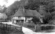
A typical East Anglian building with a pargetted facade made from low relief design pressed into the wet mortar, it dates from the 1500s, and contains some fine interior mouldings.
This is St Mary's parish church in South Street, seen from the north-east.

Looking northwards we see hostelries, public houses and stores straddle the streets, highlighting Penrith's importance as a thoroughfare on the London to Carlisle and North East to North

At the east side of the market place was the entrance to Abingdon Abbey.

Sauchiehall Street joined the east and west quarters of the city, and it was here that you could buy quality confectionery from Assafrey, dine out at the Hippodrome, attend an exhibition at the Institute

Just over two miles east of Upper Boddington, Byfield is a village that expanded with the arrival of the railway. This view is on the High Street, part of the A361 Banbury to Daventry road.

For this view Frith's photographer swung his camera north-east from view 40540 of the church looking across the water meadows. Here the stream widens and was used as a waggon wash.

Fore Street heads east from the Market Place to cross the River Parrett on the iron bridge dated 1883; this replaced an early Coalbrookdale cast-iron bridge of 1795.

Grove Street runs east from the Market Square, a mix of 18th- and 19th-century buildings, and a mix of shops and houses.

West of the Queen Street junction the London-Bath A4 was remarkably narrow, but is now pedestrianised and by-passed. This view looks east.

The view of the Bear and the adjacent buildings on the right is now hidden by High Street Colonnade.
Five miles east of Sleaford, Heckington is a village widely known for its superb 14th-century Decorated Gothic parish church with its 185 foot high spire, rich carvings and sinuous window tracery.

Looking west along the High Street, one is struck by the minimal amount of traffic. Nonetheless, in 1976 it was necessary to build the Ware by-pass to alleviate congestion in the High Street.

Here Frith's photographer looks east along Thames Street in Lower Sunbury.
Places (7)
Photos (264)
Memories (357)
Books (0)
Maps (28)

