

Places
7 places found.
Those places high-lighted have photos. All locations may have maps, books and memories.
Photos
264 photos found. Showing results 21 to 40.


Maps
28 maps found.


Books
Sorry, no books were found that related to your search.
Memories
357 memories found. Showing results 11 to 20.
Talke A Forgotten Village
As you proceed north along the A34 towards the Cheshire border you will approach Talke traffic lights and on the left and right side of the road there are two areas of grassed land. This grassed area was once the village of ...Read more
A memory of Talke in 1959
Born In Fenny Stratford
I was born at number 8 Woodbine Terrace; in attendance was nurse Brinklow the local midwife and Dr Gleeve. My parents were Jim and Vera Cusack. Just after the begining of the war my mother, ...Read more
A memory of Fenny Stratford in 1948 by
Hammer Of The Year Dance
At the end of the 1972/1973 football season, and at the age of 17, I went for the first (and only) time to the annual Hammer of the Year dance at East Ham town Hall organised by West Ham United. I went with my friend Diane ...Read more
A memory of East Ham in 1973 by
Bombing Raids In 1940
Bristol's premier shopping centre was turned into a wasteland of burned out buildings after major bombing raids in 1940, during the Second World War. Bridge Street Summary Bridge Street ran from High Street, rising up a ...Read more
A memory of Bristol by
Tweedsana Epsom High Street
Above "The Woolwich" (c1987-91) on the corner of Waterloo Road rhs also Mike Burton's "Radfords" Electrical Installation Design Consultants moved from 2a East Street(1984- 87) then to Church Street c1991-94. Mike now works from home near Plaistow, Sussex.
A memory of Epsom in 1987 by
Langstone Memories
I grew up in Langstone, living at 'Longleat' on Catsash Road from 1961-1973. I attended Langstone Primary School from 1964-1969 and then Caerleon Comprehensive from 1969-1973. 'Longleat' was one of the four semi-detached ...Read more
A memory of Langstone in 1961 by
Growing Up In Gildersome
I was born in 1952 and lived in Gildersome until I was 19 years old. My name until then was Lorraine Thompson. I have many happy memories of living in the village. Until I was 4 years old I lived in a terrace called Green ...Read more
A memory of Gildersome in 1952 by
Hounslow 1970's
I was born in West Mid Hosp and we lived in Worton Way which was technically Isleworth but very close to Hounslow High Street. Our surname was Pritchett. I went to Spring Grove Infant School in Star Road from 1962-1969 and then ...Read more
A memory of Hounslow by
A Small Childs Memorys Of North Seaton
I was born Patricia Gowans in 1957. My mam was Ettie Humble, my dad was John Gowans and we lived 3 Third Single Row with my nana and grandad Gowans. My dad worked at the pit till it closed, then he went to ...Read more
A memory of North Seaton in 1961 by
Happy Days In St Albans Road, Late 40's And 50's.
I lived at 90 East Hill just by the corner of St Albans. In St Albans lived all my little pals; Robert Ball, David Shaw, Peter Richardson, Frankie Taylor and Graham Wilson. We played in the street on ...Read more
A memory of Dartford in 1948 by
Captions
439 captions found. Showing results 25 to 48.

East Street leads into East Reach beyond which, until the last century, was open countryside. The two streets were once separated by East Gate, the old boundary of Taunton Borough.

Here we look down East Street towards the Market Hall; Silver Street is beyond, and the church tower can be glimpsed to the right.

This picture was taken eastwards from the north side of East Street, from Mrs Alice E Gale's musical instrument emporium and fancy repository on the corner with Barrack Street (left).

East Street, recorded from 1457, contains some early buildings.

On the opposite side of East Street, beside the junction with Downes Street, a sign for the Soldiers Canteen and Recreation Room (right).

Here the photographer looks west towards East Street between rows of bay-windowed and gabled 1880s Victorian lower-middle- class terraces.
On the opposite side of East Street, beside the junction with Downes Street, a sign for the Soldiers Canteen and Recreation Room (right).

In contrast to the bustle of East Street, the southern length of South Street was very much a secondary shopping area. There are fewer people and fewer cars.

As we look back up East Street, the focus of the view is the Market Hall.

The original Red Lion, after which the street was named, stood at the junction with Germain Street and, due to road improvements, was replaced by a 1930s neo-Georgian road house style pub.

This is East Bridge, at the eastern end of East Street (far right), looking eastwards from the north bank of the River Asker.

Again we are looking west from the central part of East Street with the illuminated sign carrying the initials of the Cyclists` Touring Club (far left) having dropped its `Wines and Spirits` in
Again we are looking west from the central part of East Street with the illuminated sign carrying the initials of the Cyclists` Touring Club (far left) having dropped its `Wines and Spirits
At the town centre, then as now, was the Market Square, mostly lying on the east side of the main street.

This grand war memorial by Henry Fehr was erected in 1923 on a site formed by the demolition of a number of houses at the east end of High Street, which visually linked the street to East Hill – a

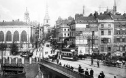
This view looks east along Oxford Street, showing the two rebuilt quadrants. The north-east one is occupied by Peter Robinson, who also have an annexe on the far side of Great Portland Street.

East Bridge, at the eastern end of East Street (left), was built by J and T Gale in 1784 and has been widened.

By the beginning of the 17th century the centre of Glasgow had shifted south, to the foot of the High Street where it joined the Saltmarket.

Bath Lane off East Street, originally called Bathing House Lane, is so named because it used to lead down to a bathing house that was located by the side of the creek.
East Bridge, at the eastern end of East Street (left), was built by J and T Gale in 1784 and has been widened.

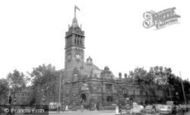
This view shows the western end of East Street, with a closer look at the Town Hall clock-tower and cupola, and Colmer`s Hill forming the conical eminence in the distance (centre).
By the beginning of the 17th century the centre of Glasgow had shifted south, to the foot of the High Street where it joined the Saltmarket.

This view, taken with the Jenny Wren behind, looks east.

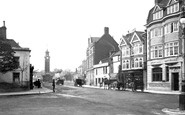
This photograph looks eastwards along East Street from the southern pavement, with the Midland Bank opposite (left).
Places (7)
Photos (264)
Memories (357)
Books (0)
Maps (28)

