

Places
7 places found.
Those places high-lighted have photos. All locations may have maps, books and memories.
Photos
264 photos found. Showing results 141 to 160.


Maps
28 maps found.
Books
Sorry, no books were found that related to your search.
Memories
357 memories found. Showing results 71 to 80.
Agnes Hunt Ward
I remember being a patient on this ward because of a fractured femur and being in traction for three months, it was the summer of 1978 and roasting. We were wheeled through great big doors at the side of the ward and into the grounds, ...Read more
A memory of Heswall in 1978 by

Mitchell Family
I have been tracing my maternal grandmother's family for some time now. My grandmother was born in Shoreditch in 1908, and my mother was born there too in 1929. My nan was born in New North Road, and I found out that her ...Read more
A memory of Shoreditch by
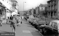
East Street 1965
The lady with the shopping bag and wearing sunglasses in this picture is my mother, Hilda Hounsell. She had either visited the library or her sister who lived at the bottom of Easst Street.
A memory of Bridport in 1965 by
Those Were The Days 1
Growing up in the 50s and 60s in London's East End (well the Essex side of it). I was born on April 14th 1952 at Upney Hospital. I attended Northbury infants and junior schools and then went to Eastbury Secondary Modern. I ...Read more
A memory of Barking in 1950 by
Saltfleet Fishing In The 1970s
Through the 1970s my grandad, Sam Stokes, had a caravan on Sea Lane on Sandyfields Site. I think the owner at the time was a Mrs. Shidell. I usually went with my cousin Nigel and we spent the days fishing for eels ...Read more
A memory of Saltfleet in 1978 by
The Delta
This memory of 1961, and me and me pal Wes Coulthard started work at the Delta Rolling Mills (this was over Scotswood Bridge towards Blaydon, left along the river by the Skiff Inn). It was hard work but the dosh was better than other ...Read more
A memory of Newburn in 1961 by
A Walk From Shotgate Baptist Church To The Nevendon Road Part 2 See Part 1 Below
Continued from Part 1 below. Next to Martins Bank was a record shop, where I remember going with my parents and standing listening to records in the small listening ...Read more
A memory of Wickford by
A Walk From Wickford High Street Down The Rettendon Raod
My name is Kevin Mears, I lived in Wickford from my birth in 1958 until I got married in 1980. I shall describe my memories of Wickford in the 1960s and 1970s as a couple of walks around the ...Read more
A memory of Wickford by
The Metropole Hotel
The hotel which features in this photo is the Metropole Hotel which was situated in Tucker Street. It had access at the rear leading down to the Promenade. Following WW2 it fell into disrepair and was demolished being replaced ...Read more
A memory of Cromer by
Bovey Tracey
I was born in Bovey at what is now the Old Library in East Street, but in 1937 was the Liberal Club. My Godfather Dick Smaridge lived just down the street at Number 14. After his son Eric was shot down in the War I mostly lived with ...Read more
A memory of Haytor Vale in 1954 by
Captions
439 captions found. Showing results 169 to 192.

This yard, complete with children posed on the steps in the centre, led off Stramongate, the main approach to Kendal from the north-east, from Penrith or Appleby.

This interesting view was taken from the western side of the river from the site of today's police station, and shows many of the yards along Church Street.

The village of Portloe (meaning 'bay with pool') is one of Cornwall's best-kept secrets - a tiny, rocky fishing cove with narrow streets and the fine 17th-century Lugger Inn.

Lace-making has always been an important tradition in East Devon, though it would be a rare sight today to see it carried out in the street by a local cottager.

In July 1943 the town received attention from the Luftwaffe, but the only building to be destroyed in the High Street was Brooker Bros premises, still not replaced when this picture was made.

Temple Square was probably a principal crossroads in the 10th-century Anglo-Sacon burh, with Kingsbury the market place at the south-east corner of the early town.

The main shopping centre is in the High Street to the east, leading away from the parish church, and Broad Street to the west.

Further west, the High Street meets Abingdon Road (right) and Steventon Road (left) in a small green.

This was the older of Whitby's two shopping streets. Puckrin's chemist's shop (the white building on the right) stood for a further forty years.

Bridge Street, looking east. Sweet jars are clearly visible in Furr's window. Three doors up is J B Crone, a furniture dealer; next door, W H Walker sells cycles.

Frith's photographer looks east towards Kensington Church Street in the distance.

Eckington is another north-east Derbyshire town which formerly depended on the collieries which surrounded it, but which now is finding a new focus as a commuter town for Chesterfield and Sheffield.

This gently curving street is to the east of the town. This view, looking back towards the town centre, shows both the Congregational and parish churches.

On 30 August 1940, a 100kg bomb scored a direct hit on Park Street bus depot, killing one person and creating a temporary bus shortage.

The 17th-century Angel Inn stands at the east end of Middle Street and the start of Main Street, and is one of a number of interesting buildings around the area.
This gently curving street is to the east of the town. This view, looking back towards the town centre, shows both the Congregational and parish churches.

Looking east along High Street, which was dominated by the spire of Sir Giles Gilbert Scott's church of St Nicholas and St Runwald.This replaced two older churches (St Runwalds and St Nicholas

This view is along Eastgate, east of the crossroads with Northgate ('gate' being Danish for street, rather than gate) and Minster Yard.

Known just as Lyng, East Lyng is strung out along the busy road over the Levels from Taunton to Street. The Rose and Crown (centre left) survives.

From the Market Place our town tour heads south along perhaps the best street in Abingdon for the survival of older buildings: East St Helen Street. We

Already falling into disrepair in Victorian times, thatched cottages on the east side of South Street, beside South Bridge, would soon succumb to the front-line of urbanisation.

East Budleigh's main street has changed little since this photograph was taken at the outbreak of the Great War.

Station Street turns east from the High Street, and once led to the railway station on the branch line from Gainsborough to Doncaster, closed since the 1960s.

Broadly speaking, the valley along Broad Street and Berkhamstead Road was for artisans and the working classes, the areas to east and west were middle class.
Places (7)
Photos (264)
Memories (357)
Books (0)
Maps (28)

