

Places
36 places found.
Those places high-lighted have photos. All locations may have maps, books and memories.
- Bangor, County Down
- Newcastle, County Down
- Greyabbey, County Down
- Donaghadee, County Down
- Downpatrick, County Down
- Portaferry, County Down
- Dromore, County Down
- Hillsborough, County Down
- Downings, Republic of Ireland
- Killyleagh, County Down
- Ardglass, County Down
- Rostrevor, County Down
- Dundrum, County Down
- Newtownards, County Down
- Warrenpoint, County Down
- Ballygowan, County Down
- Ballywalter, County Down
- Ballyward, County Down
- Bishops Court, County Down
- Boardmills, County Down
- Culcavy, County Down
- Katesbridge, County Down
- Killough, County Down
- Millisle, County Down
- Portavogie, County Down
- Saul, County Down
- Seaforde, County Down
- The Diamond, County Down
- Audleystown, County Down
- Kearney, County Down
- Annaclone, County Down
- Ballyhalbert, County Down
- Ballymartin, County Down
- Clare, County Down
- Conlig, County Down
- Dollingstown, County Down
Photos
856 photos found. Showing results 1,661 to 856.
Maps
459 maps found.
Books
2 books found. Showing results 1,993 to 2.
Memories
8,167 memories found. Showing results 831 to 840.
The Railway Bridge
In this picture I can remember that on the left was W H Smith's, a bicycle shop and an Options on the corner of Colham Road. To the right between the two pubs many years earlier was Pat's Garage. In the picture we have the new ...Read more
A memory of West Drayton in 1954 by
Mossband Camp
My father was a serving soldier, serving at the RAOC camp until 1948. We lived in the YMCA building in the camp itself and it had a large functions hall attached where one of our officers once entertained the children at Christmas ...Read more
A memory of Mossband Ho in 1947 by
Sad Days
Unfortunately Barming doesn't go down well in my memories, I was only a child but I remember going with my dad and brother to what I thought was a hospital but it wasn't, my mother was locked up there several times and I found out much later ...Read more
A memory of Barming in 1963 by
St Mary's School
It is believed that this was a training college for Church of England vicars and then it was subsequently used as an orphanage run by the Catholic Rescue Society and staffed by the Sisters of Chariry, a French order of nuns. During ...Read more
A memory of Gravesend in 1930 by
Baptist Church
The building with a clock tower on the right was the old Baptist church. It was knocked down in the early 1960s in order to widen the road (which was of course the main Portsmouth to London road in those days) and was replaced by ...Read more
A memory of Waterlooville by

Penzance Market Jew Street
As a boy I must have walked up and down Market Jew Street hundreds of times. In particular I along with friends would visit the local Woolworth's where we liked to partake of various flavoured "Milk Shakes" Later during ...Read more
A memory of Penzance in 1940 by
First Love
1995 was the best year of my life, I was aged 13 and I was totally besotted with a lad in the village called James Power, he was working with a local builder from Penmachno called Jeremy McWilliam. I loved the way he was of being the ...Read more
A memory of Cwm in 1993 by
Now St Georges Square
At the junction of Williamson St, opposite the Town Hall. Local corporation bus company had a terminus halfway down Williamson St. Also Fyffes bananas had large depot opposite parked buses.
A memory of Luton in 1950 by
Mobo Horses
We moved to Prestatyn in 1948. I loved the Mobo horses that the little ones could ride at the Bastion Road beach. My little school was Pendre, up the hill Fforddlas I think. Also going to St Chad's School annual fair and sale. Always ...Read more
A memory of Prestatyn in 1950 by
Captions
2,242 captions found. Showing results 1,993 to 2,016.

This view looks south down the High Street past a motor bike with its acetylene headlamp towards the old Market House with its cupola.

It was a co-educational school until the Girls' County School was built further down Buttrills Road.

It is rather surprising that most of the buildings in the shot have survived, although generally in a down-graded form. The bushes on the right have gone, to be replaced by shops.

This shows the town, the railway and the headland. The first station had been provided only 20 years before.

It was built mainly in the 12th to the 14th centuries, but exhibits work of every period down to the present day.

The huge cedar tree towering over the 'New Laid Eggs' sign was blown down by a gale in the 1970s.

Much of the pulled-down abbey found its way into the church, including the misericords.

The two Llanwenarths were joined by a rope ferry, which closed down in 1951. From the churchyard there is a magnificent view of the Blorenge mountain.

It has since been filled in and closed down. Wisbech is the capital of the Fens. It was once a strategic seaport, where coasters transhipped their cargoes into fenland lighters.

Horse-drawn ambulances, taxi cabs, flat wagons, and even a horse bus were used to convey the patients down to the new Royal Infirmary on Oxford Road.

Along with Deal and Sandown, Walmer was one of the 'Three Castles which keep the Downs'.

This event, staged on a hot June day, marked the acquisition of the sixty acres of Colley Hill, overlooking the town, by the National Trust after a lengthy fund-raising campaign to gather the £5000 needed

Above the third vehicle, making its way down the High Street towards the junction, is the sign of the original Harrow Inn, which was demolished in 1934 and replaced by the present building.

On the left, next to the Lloyd's Bank branch, is the fashion shop of Renee Shaw, with Fuller's tea shop, Dewhurst's the butcher's, and John's menswear shop further down the hill.

They had blacked-up faces and wore a sort of clown outfit with pom-poms down the front. They played twice daily on the beach.

The Walmer Stores in the centre of this photo has its blinds down.

The High Street, fashioned in the 1930s, drops down to the original village centre, with the graveyard to St Martins church on the immediate right.

The area around Glasson is teaming with wildlife, and is a bird watcher's paradise from Conder Green down to Cockerham Sands in the south. Swans and ducks live in the canal basin.

Green from the far side.The village (the name means 'the dwelling by the bow of the river') has two greens; because it was all part of the Pudsay estate, there was no pressure to expand or to pull down

During the Second World War, Mrs Armitage, who had taken to using her pony and trap to save petrol, would tie the pony up to the pump when she came down to the village to shop, never mind

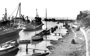
Coal was imported down to the mid 20th century – we can see a small Dutch coaster discharging her cargo, with coal heaped on the quayside (centre).

This view is looking down from the road bridge; things have changed greatly at Sandy.

This attractive view is little changed today, except that the Green, predictably, is kept close-mown now, and woe betide any daisy that shows its head.

Here we see the front face of Owen's College on Oxford Road, and you can see similarities to the Assize Court, and even the Town Hall, all of which were designed by Alfred Waterhouse.
Places (198)
Photos (856)
Memories (8167)
Books (2)
Maps (459)

