

Places
7 places found.
Those places high-lighted have photos. All locations may have maps, books and memories.
Photos
297 photos found. Showing results 281 to 297.


Maps
28 maps found.
Books
Sorry, no books were found that related to your search.
Memories
357 memories found. Showing results 141 to 150.
Grays Thurrock Essex England Uk 1935 1953
My memories of Grays go back to the 1940's and 1950's the war years and before the London over-spill estates Of Belhurst Park and Basildon arrived. I was born and lived at 106 Bridge Road with my parents Thomas ...Read more
A memory of Grays in 1940 by
Ramsgate C 1952
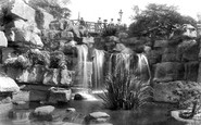
I was born in Ramsgate in 1950 in Addington Street where my father and mother had a drapers shop. My mother used to take me out all over the place but my favourite of all was the Waterfall, as a child I remember the coloured lights that ...Read more
A memory of Ramsgate by
Conkers
I seem to remember that this section of Upton Park had its entrance at Sussex Place (at the East end of the High Street, just past Upton Road) Many an hour was spent walking/running through this section on route to Lacelles playing fields on ...Read more
A memory of Slough by
Living With Nan And Grandad
I was born in the back bedroom of my nan and grandads house in Wellesley Road Wanstead. We did not have much but all worked together, my great aunt Flo and uncle Arthur lived in the basement, they also had a bedroom ...Read more
A memory of Wanstead in 1948 by
Dad Invented The Word 'gertcha'.
We moved from Steed Road Huswell Hill, where i was born,to Northview Road N8 in 1938. Jumping to 1941 Mum, Dad, brother Bill and me lived at the bottom end opposite, Southview Road. A stick of bombs dropped on our end of ...Read more
A memory of Crouch End by
Days Kids
My memories of Mexborough were playing by the canal down ferry boat lane of church street , canal barges would come along and we would open the old bridge and let them through and the boat man would throw us pennies for our help. We would go ...Read more
A memory of Mexborough by
Animal House
From 1947, my family used to drive between Middlesex and West Suffolk via Baldock. My father used to point out a house on the East side of the High Street that had many animal figures on the street-facing wall. Does anyone remember it and perhaps have a photograph?
A memory of Baldock by
Brentwood High Street
I remember this view like it was yesterday. It is looking east towards Wilsons Corner. On the right is the Arcade and on the left side of the Arcade is a shop called Sacks & Brendalls (might have been Sacks & Brendlaw..). ...Read more
A memory of Brentwood by
Born In Aldershot In 1946
I was born in Aldershot in June 1946. I believe the event was at the General Hospital at the top end of St.Georges Road. For the first year or so I lived with my parents and older brother at the bottom end of Victoria Road. We ...Read more
A memory of Aldershot by
Proud To Have Come From Shaw
I think to reminisce is great. At 76, I find myself doing this quite often and am drawn back to Shaw, and to High Crompton, where I was born. The house I was born in on Rochdale Road, near the Bull's Head Pub, is still ...Read more
A memory of Shaw by
Captions
445 captions found. Showing results 337 to 360.

Five miles east of Sleaford, Heckington is a village widely known for its superb 14th-century Decorated Gothic parish church with its 185 foot high spire, rich carvings and sinuous window tracery.

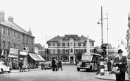
Looking west along the High Street, one is struck by the minimal amount of traffic. Nonetheless, in 1976 it was necessary to build the Ware by-pass to alleviate congestion in the High Street.

Here Frith's photographer looks east along Thames Street in Lower Sunbury.

Reference has already been made to the rapid expansion of Sheffield's east end - Brightside, Attercliffe and Darnall - to accommodate the tens of thousands of new workers in the heavy steel industry

The main street of Allington village (bottom left) leads into this panorama of Bridport, looking south-east from the town's open country, with St Swithun's Church the prominent building (centre right).

Consisting of little more than one long street running east to west, Glanton enjoyed a reputation for the healing properties of the water from the Keppin or Keppie Well situated behind the old school

The town-village grew up where the Roman Stane Street crossed the River Arun.

This view was taken looking east from Bridge Street past the bridge across the mill stream (the river itself is out of shot a hundred yards away to the right), which was dug for the abbey in the 10th century

The Village 1923 Once back to the A39, continue east, and about a mile west of Minehead, turn left to descend into Bratton, a tucked- away village with an excellent 15th- century manor house,

It takes its name from the adjacent Stile Path through the bushes (top left) from Pound Street to the Cobb. It was the home in Victorian times of Frank Morris.

It stands on the east side of Duck Street at its junction with Mill Lane. Renovations in the 1990s revealed a 'witch bottle' containing liquid that was probably urine concealed inside the chimney.

Looking east from the western end of the village, we can see the road junction beside what has become a single Burwell Cottage (centre). Rectory Lane used to be called Duck Street.

Leaving the town centre we move along Church Street to the Missenden Road, just past the junction with Pednor Road and Wey Lane.

This picturesque Cotswold town in Oxfordshire lies on the slope of a steep hill above the Windrush valley about 20 miles east of Cheltenham.

A couple of miles north-east of Ticehurst, Flimwell is a small village bisected by the London to Hastings road, now the A21, which crosses the foreground of this view.

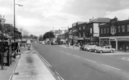
At the west end of the High Street, London Road curves away north-west downhill.

North-east of Guildford and now by-passed by the A3, Ripley has a long wide High Street and was full of coaching inns in earlier days.

On the right, Gordon Thoday, with branches throughout East Anglia, sold dress fabrics.

We are looking downhill from the east, and the entrance to D H Lawrence's Victoria Street can be seen half-way down on the right by the white building.

We are looking downhill from the east, and the entrance to D H Lawrence's Victoria Street can be seen half-way down on the right by the white building.

The Sir Frederick Milner School was built as a secondary modern school in the south- east of the town, amid a maze of narrow streets.

This looks Southwards along South Street to St Mary`s parish church (centre).

Moving east we reach Coleshill, a mile south of Amersham.

Harrow Park winds away to the east of the High Street, past one or two rather grand houses, to arrive at Deynecourt at the foot of the hill.
Places (7)
Photos (297)
Memories (357)
Books (0)
Maps (28)

