

Places
17 places found.
Those places high-lighted have photos. All locations may have maps, books and memories.
- Bridge End, Oxfordshire
- Bridge End, Lincolnshire
- Bridge End, Essex
- Bridge End, Bedfordshire
- Bridge End, Clwyd
- Bridge End, Warwickshire
- Bridge End, Surrey
- Bridge End, Durham (near Frosterley)
- Bridge End, Northumberland (near Hexham)
- Bridge End, Hereford & Worcester (near Tirley)
- Bridge End, Hereford & Worcester (near Bosbury)
- Bridge End, Shetland Islands
- Bridge End, Cumbria (near Carlisle)
- Bridge End, Northumberland (near Hexham)
- Bridge End, Devon (near Kingsbridge)
- Bridge End, Devon (near Sidmouth)
- West End, Yorkshire (near Pateley Bridge)
Photos
38 photos found. Showing results 1,021 to 38.
Maps
520 maps found.
Books
Sorry, no books were found that related to your search.
Memories
1,928 memories found. Showing results 511 to 520.
The Nursery
I was born in 4 The Nursery in 1944. My gran Elizabeth Bayles, my mother Emma Bayles. I went to Millbank School at age 4yrs. I can remember my first teacher there Miss Watkins. My Mother worked at Lockeys buses as a bus conductor. ...Read more
A memory of West Auckland in 1953 by
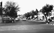
That Morris Minor Traveller Has To Be Our Dad's Car!
My family lived at No 3 (the top flat), Corner House, at the top end of Broad Street, first on the left looking at the photo (but just out of the picture) for many years from 1947 or so. I ...Read more
A memory of New Alresford in 1947 by
Ledgers Greengrocers
Have just read about the gentleman who worked for Ledgers. I lived in Exeter Rd, and used to play with Joanne Ledger. I also remember going in the van with bench seats. I vaguely remember it being something to do with the ...Read more
A memory of Dagenham in 1960 by
50s 60s Memories
I was born at 13 Alma Place (up the small alley from Argent Street) in 1952, moving to number 6 when I was 5. When I was 9 we moved to Sherfield Road, where I lived until 1970 when we finally moved to Shipston-on-Stour, Warwickshire, ...Read more
A memory of Grays by
Abingdon St
I have fond memories of visiting our grandparents on our mother's side, who lived at number 8. We recited the "ABC" streets and I can remember Smythes the cake shop at the top of the street, where we bought Snowball cakes from. We also ...Read more
A memory of Sunderland in 1953 by
My Local Shops
These were my local shops. We used to live in the flats adjacent to these shops called 'Morden House', then there was the 'White Bridge' which went over the railway lines to the underground sheds. The first shop on the corner I remember ...Read more
A memory of Morden in 1962 by
Awalk With Grandfather
A walk with grandfather « Thread Started Yesterday at 2:03pm » -------------------------------------------------------------------------------- A Walk with Grandfather. I was about 11 years old, one summer's day, when ...Read more
A memory of Stramshall in 1930 by
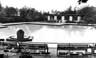
Marsden Park Swimming Pool
I have a host of memories of MPSP. The earliest is from the 1950s when I used to play on the fountain -- seen in the foreground -- with my cousins (Towers) who would visit from Cleveleys. It was also the first place where I ...Read more
A memory of Nelson in 1967 by
My Childhood
The nicest thing about growing up in Clun in the 1940s was that it was one big happy family. We all knew each other, and cared. I loved standing in the blacksmiths in Bridge Street, watching Mr Griffiths shoe horses, and on a cold winter's ...Read more
A memory of Clun in 1940 by
Not Much Money But Plenty Of Happy Memories
I moved to Dagenham with my family in 1949. We lived in Cartwright Road off Hedgemans Road. I have memories of long hot summer holidays off from Finneymore Road School. The days were filled with trips to ...Read more
A memory of Dagenham in 1950 by
Captions
1,755 captions found. Showing results 1,225 to 1,248.

It is obviously safe for the young man in the cap and high starched collar to stroll across the bridge. Just behind him is the Lamb Inn, which closed the year this photograph was taken.

Once the canals ceased to be used for the transport of goods, it did not take long for them to become silted up and overgrown. Notice the route of the towpath going over the bridge.

The minor road off the B1249 rises with dwellings on either side, peaks and falls again to an old wooden bridge with rusted iron railings that crosses brackish water which eventually falls into

In this view we see the largely rebuilt High Bridge buildings with the brickwork and stonework still looking fresh.

The Ha'penny Bridge was built in 1792 to replace a ferry. It is an elegant single arch with a tall, pyramid-roofed tollhouse, and so named because of the original crossing toll.

Well before it became a favourite bathing and picnic spot, the Lune's beauties at Caton were extolled by the poets Wordsworth and Gray, and Turner came to paint the scene.

Looking back into Bridge Street with Burden's Corner now well established, the London County & Westminster Bank opposite retained its authentic late Victorian frontage.

Here the photographer looks north along the High Street, towards its junction with Bridge Street to the right, and Desborough Road curving left.

Maynscroft restaurant and café and the adjoining William's cycle shop (right) closed shortly after 1955 and became dwellings. The Queen's Head closed in c1990 and is now a restaurant.

Here we see the Black Rock, Black Rock Quarry and Black Rock Cottage, and behind is the bridge over the railway.

A locomotive of the L C & D Railway has just left Holborn Viaduct Station and thunders south over the bridge, steam ballooining out over the roofs. Below, traffic crawls miserably up Ludgate Hill.

As we pass beneath the bridge, still on the Egham bank, the 18th-century Swan Hotel on the right now also occupies the boathouse and garage in front of it, behind the ladies with their parasols.

A 17th-century packhorse bridge spans the River Yarrow, and beyond the cottages rises the square, battlemented tower of St Michael and All Angels' Church.

The Shropshire Union Canal, engineered by Thomas Telford and con- structed between 1827 and 1835, was the last of the major canals.

The Shropshire Union Canal, engineered by Thomas Telford and con- structed between 1827 and 1835, was the last of the major canals.

By 1928, the Rustic Bridge seen in photo 40743 had been taken down. The two houses on the left were owned by Spicer Brothers, who owned the paper mill, and were called Orps Mill Cottages.

Perhaps the best-known feature of Burnsall is its magnificent, five-arched stone bridge across the River Wharfe, seen here from the river.

In the background is the ivy-clad nine-arched bridge spanning the Fowey River.

This splendid view of the High Street as it ascends the hill towards the Guildhall was taken from the Town Bridge crossing the River Wey.

Looking down the hill from above the station, we see the bridge carrying the Settle- Carlisle railway line running along the edge of the village.

Thomas Hardy used the Manor at Wool as the setting for the disastrous honeymoon of Tess and Angel Clare in his novel 'Tess of the D'Urbervilles'.

This was designed by John Oldrid Scott, second son of the great Victorian architect, George Gilbert Scott, who built Clifton Hampden's bridge over the Thames further upstream, as well as St Pancras station

Seen from the footbridge to the Oxfordshire bank, the eleven-arch bridge is an 18th-century one that carries a vast amount of traffic, for Sonning is in effect Reading's eastern by-pass.

The corner of Eastgate Street and Bridge Street. The buildings are from the Victorian half-timber revival period, designed by T M Lockwood in 1888. This area of the city is known as The Cross.
Places (17)
Photos (38)
Memories (1928)
Books (0)
Maps (520)

