

Places
36 places found.
Those places high-lighted have photos. All locations may have maps, books and memories.
- Bangor, County Down
- Newcastle, County Down
- Greyabbey, County Down
- Donaghadee, County Down
- Downpatrick, County Down
- Portaferry, County Down
- Dromore, County Down
- Hillsborough, County Down
- Downings, Republic of Ireland
- Killyleagh, County Down
- Ardglass, County Down
- Rostrevor, County Down
- Dundrum, County Down
- Newtownards, County Down
- Warrenpoint, County Down
- Ballygowan, County Down
- Ballywalter, County Down
- Ballyward, County Down
- Bishops Court, County Down
- Boardmills, County Down
- Culcavy, County Down
- Katesbridge, County Down
- Killough, County Down
- Millisle, County Down
- Portavogie, County Down
- Saul, County Down
- Seaforde, County Down
- The Diamond, County Down
- Audleystown, County Down
- Kearney, County Down
- Annaclone, County Down
- Ballyhalbert, County Down
- Ballymartin, County Down
- Clare, County Down
- Conlig, County Down
- Dollingstown, County Down
Photos
856 photos found. Showing results 1,521 to 856.
Maps
459 maps found.
Books
2 books found. Showing results 1,825 to 2.
Memories
8,167 memories found. Showing results 761 to 770.
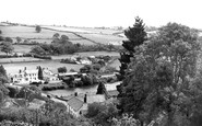
View Down Onto Umberleigh Bridge, Showing Village Square
It is with great interest we see your picture of the village square, showing what is now the Post Office and largest post code sorting office in England. It also shows the Regency Gables Tea ...Read more
A memory of Umberleigh by
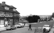
Moving Of The War Memorial
Note in this photo that the war memorial has been moved back and the wall lowered. Flats have been built on the Banstead house site. You could always see the green houses over the high wall from the top of the 164a bus. The ...Read more
A memory of Banstead in 1956 by
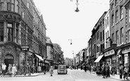
The Cadena Cafe
This shot of the High Street presents the signage for the Cadena Cafe, a chain of national cafes (in the 'Lyon's' mould) where shoppers met for coffee and light meals. I have fond memories of visiting the cafe with family and friends, ...Read more
A memory of Worcester by
Childhood Memories
Knutsford holds a special place in my heart as I was born there in 1956 and spent nearly eight years of my childhood growing up in this then safe and close community. I have very strong memories of family, home, school and friends ...Read more
A memory of Knutsford in 1962 by
Village School
To the left of where the photographer was standing was the junior's playground of the old village school (St Mary and St Margaret's.) In 1963-4 we would have vacated the old buildings and moved into a new building in Southfield ...Read more
A memory of Castle Bromwich in 1965 by
The Hump
Just on the other side of the bridge you can see the footpath leading up and over a mound. This mound was built up in preparation for a projected relief road from the Midland Railway station to the Sheepmarket (on the other side of the ...Read more
A memory of Stamford by
Family Day Out Clerkenwell To Caterham 1925
The above photo depicts Dorothy Connor (nee Step) aged 10, with her late Mother Elizabeth Step (aged 46) and her Sister, Florence Step (aged 21) having alighted from the 159a Bus which brought them from their ...Read more
A memory of Caterham by
My Early Years
On the 2nd September 1952 I was born at Manor Farm. I lived there with my parents, my maternal grandfather and two older brothers. I know my grandmother was alive when I was born but, unfortunately died soon after. My grandfather ...Read more
A memory of Yealand Conyers in 1952 by
The Town Hall Steps
When I was very young I can remember that my mother used to let me run up and down the town hall steps.
A memory of Llantwit Major in 1975 by
Worthing Front Or Silverstone
In about 1935, when I was 5 years old, my Grandfather used to take us all on gentle rides into the South Downs from his home at 11 Gaisford Road in his circa 1930 Hillman Minx. The beloved Minx was not turbo-charged and ...Read more
A memory of Worthing in 1930 by
Captions
2,242 captions found. Showing results 1,825 to 1,848.

Unlike many of its rivals, the Staffordshire & Worcestershire never sold out to the railway companies, some of whom made a policy of buying up canals, then running them down so that they could gradually

Opposite, the Port Bredy Guest House takes its name from that used for the town in the Wessex novels of Thomas Hardy. Victoria Grove branches off between the trees (right).

Going north to the Godstone to Reigate road, that part of the A25 that runs along the greensand ridge south of the North Downs, we reach the village of Bletchingley.

The 1890s terrace with its four gabled full-height bay windows steps down the hill; the left-hand one on the corner of Outwood Lane is now no longer a Barclays Bank, but the offices of financial consultants

Note the house halfway down the street on the left with six windows and a central pedimented doorcase. This is Unicorn House, No 28, which had its moment in history.

Wareham St Martin's (right), standing on King Alfred's Town Walls, is Dorset's earliest complete church. Anglo-Saxon arcading was replaced by Norman arches in the 12th century.

You could get your feet wet stepping down into the Southdown Omnibus Office over on the far side of the Square and what on earth is that greenhouse doing in front of the statue?

Down past the latticed railway bridge is the new road over the bridge to Middleton. At this time, before the First World War, the town is still very relaxed.

Narrow boats entered a caisson along the trough to the left and were lowered down to the river. One such can be seen sandwiched between two barges.

The walls have been constructed of flints (which are copious in the chalk hills of the South Downs) and edged with stone at the windows and doors.

The building is of about 1300 with an unbuttressed west tower of 1707, when its spire was taken down. As

The bare chalk in this view of the Whiteleaf Cross is nowadays not seen so clearly; the downs have since become covered in trees and scrub, with woods in the middle distant field.

As we move further west, we see a part of St Mary's Street with an interesting mix of buildings with alleys leading down to the river front and The Meadows.

The smock mill on the right, so called because of its resemblance to a countryman's working dress, became derelict and was blown down some years ago.

This lane from the hamlet of Shore snakes down the hill past a huge mill chimney.

We are on the Downs between Brighton and Lewes. Near the rebuilt church there is a thatched barn and an early dewpond.

main London to Worthing Road at the foot of the Downs.There are fine views of Chanctonbury Ring, a ring of beech trees planted on the site of an Iron Age hill fort 800 feet up on the top of the Downs

We are on the slope of the Downs between Eastbourne and Polegate. A nearby vantage point at Combe hill is 638 feet high.

Banstead station, on the branch line from Sutton to Epsom Downs station, opened in 1865.

When this picture was taken it was rather run down, but a major refurbishment has improved it wonderfully.

Mr Chapple opened his garage further down the street in 1914 – note the petrol pumps on the pavement – and on either side are a barber's shop and a café advertising teas.

This was one of the many narrow alleyways leading down to the harbour area. From here children could play safely, and the fishermen could prepare their nets and their boats.

The 180ft-high spire dominates the town, and looks down onto the heart of the shopping area.
It is still a popular tourist attraction - note the figures looking down on the visitors from Marten`s Tower.
Places (198)
Photos (856)
Memories (8167)
Books (2)
Maps (459)

