

Merry Christmas & Happy New Year!
Christmas Deliveries: If you placed an order on or before midday on Friday 19th December for Christmas delivery it was despatched before the Royal Mail or Parcel Force deadline and therefore should be received in time for Christmas. Orders placed after midday on Friday 19th December will be delivered in the New Year.
Please Note: Our offices and factory are now closed until Monday 5th January when we will be pleased to deal with any queries that have arisen during the holiday period.
During the holiday our Gift Cards may still be ordered for any last minute orders and will be sent automatically by email direct to your recipient - see here: Gift Cards
Places
36 places found.
Those places high-lighted have photos. All locations may have maps, books and memories.
- Cardiff, South Glamorgan
- Barry, South Glamorgan
- Penarth, South Glamorgan
- Rhoose, South Glamorgan
- St Athan, South Glamorgan
- Cowbridge, South Glamorgan
- South Molton, Devon
- Llantwit Major, South Glamorgan
- Chipping Sodbury, Avon
- South Chingford, Greater London
- South Shields, Tyne and Wear
- Ayr, Strathclyde
- St Donat's, South Glamorgan
- Llanblethian, South Glamorgan
- Thornbury, Avon
- Llandough, South Glamorgan
- Fonmon, South Glamorgan
- St Nicholas, South Glamorgan
- Jarrow, Tyne and Wear
- Penmark, South Glamorgan
- Font-y-gary, South Glamorgan
- Maybole, Strathclyde
- Yate, Avon
- Oxford, Oxfordshire
- Torquay, Devon
- Newquay, Cornwall
- Salisbury, Wiltshire
- Bournemouth, Dorset
- St Ives, Cornwall
- Falmouth, Cornwall
- Guildford, Surrey
- Bath, Avon
- Looe, Cornwall
- Reigate, Surrey
- Minehead, Somerset
- Bude, Cornwall
Photos
5,054 photos found. Showing results 1,121 to 1,140.


Maps
2,499 maps found.


Books
1 books found. Showing results 1,345 to 1.
Memories
1,580 memories found. Showing results 561 to 570.
The Ferry Boatman Disaster
Sad boat accident Monday morning 26th March 1877 at Ryton. There were two brothers named Scott who lived in a house on Ryton Island, this was just below Moor Court. (You can read about this in my other stories). The brothers had ...Read more
A memory of Ryton
Southall 1950's
We lived in Hillingdon but I used to often visit Southall as a child as my father and uncle had shops in South Road. On Saturday my father and I used to arrive early morning then visit a cafe a few doors away with plasticised tables ...Read more
A memory of Southall by
Recollections Of Ash Vale By Lt Col Taylor
RECOLLECTIONS OF ASH VALE By Lt Col Taylor Ash Vale, viewed from the main route through it the Frimley and Ash Vale roads would not have appeared to alter a lot during the last 100 years. Houses do now ...Read more
A memory of Ash Vale by
Ballymacscanlon And Wonderfull Ireland
I worked as a consultant engineer in Ireland in the early nineteen ninety's staying in the Carrickdale hotel in Dromad, just over the border, as my base in the South whilst working in Newry. I also traveled ...Read more
A memory of Ballymascanlon by
Scotts Cycles South Ealing
Scotts cycles was at the junction of South Ealing Road and the road to Gunnersbury Park. It was a double fronted shop. He made bicycles there. I went there for tyres etc. My dad had a bike and tandem made there.
A memory of South Ealing by
Dad Invented The Word 'gertcha'.
We moved from Steed Road Huswell Hill, where i was born,to Northview Road N8 in 1938. Jumping to 1941 Mum, Dad, brother Bill and me lived at the bottom end opposite, Southview Road. A stick of bombs dropped on our end of ...Read more
A memory of Crouch End by
New Addington Memories
I remember as a young boy Fairchildes school , we lived in Castle Hill Crescent and walked in all weathers to school. I remember Mr. Hedges, Mr. Breed, Mr. Watson, Mr. Fuller, Mr. Rutter Mr. Morgan, Mr. Best, Mr. Trinder, ...Read more
A memory of New Addington by
The Johnsons
My Grandparents, Albert and Ada Johnson, lived in a little cottage overlooking the village green around the turn of the 19th century, where they brought up seven of 13 children. I think grandad was the doctor's gardener and grandma ...Read more
A memory of South Ockendon by
Unanswered Questions
I used to drink in The Woodman on occasion as I lived on the Clock House Farm Estate between 1957 and 1962 when I was married just across the road in St Peters.Question,what happened to the board with the pilots names on it ...Read more
A memory of Woodmansterne by
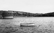
Trimpley Reservoir
The picture is of Trimpley reservoir taken from the yacht club slipway looking towards the south-eastern end of the reservoir somewhere around 1969 as in 1965 the contractors were still moving the soil to create the reservoir. ...Read more
A memory of Kidderminster by
Captions
2,444 captions found. Showing results 1,345 to 1,368.

The market originally took place on the Green, but was confined to the south side of it after the Chapel on the Green was built in 1805.

The rest of the village is to the south. The driver of the Triumph Herald 1200 patiently waits, with his window wound down, for his wife to post a letter and buy a newspaper.

Newhaven's promise to become 'the Liverpool of the South' has never materialised, and the cross-channel link (transferred here from Shoreham in 1849) has in recent years suffered from threats of closure

Little remains of the original structure save for the south wall of the chapel. It was redeveloped in the 1760s, and a new master's house was added in 1832.

Corfe Mullen stands on the alluvial flood plain of the River Stour, surrounded originally by the wild heathlands of south-east Dorset.

Upton is situated upon the Severn some ten miles south of Worcester.

Here, a little south of Cookham, is the My Lady Ferry with the lock-keeper's cottage on the far bank.

Even as late as 1728 the road south was worn deeply with heavy carriages.

On the lane south from the crossroads the last two houses on the left are timber-framed, the White Cottage on the left with original framing in the side elevation and fake to the front.

Further south, High Street opens up to the river, the buildings terminating in an elegant early 19th-century five-storey warehouse with a hipped roof: more like a very tall villa than a warehouse.

In this view, the photographer looks south-east back past the corner of High Street to St John's Street and St John's 15th-century west tower. To the left is St Mary's Church spire.

Ludford is a now a single-street village on the Louth to Gainsborough road at the head of the River Bain, which flows south through the Wolds to join the River Witham.

Billy Banks Wood, prominent in views from Castle Walk, is ancient 'hanging' woodland clinging to limestone rock on the south bank of the River Swale just west of Richmond Castle.

A chip on the south west corner is shrapnel damage from the blitz.

Among the church's interesting curiosities are a sundial on the south wall, a stout Norman tub font and a delicately carved 15th-century pulpit.

Ogmore lies two miles to the south-west of Bridgend.

Bramley Road to the south has an avenue of horse chestnut trees.

We are south-west of the village centre, and the photograph exudes a strange feeling of well- cared-for neglect.

The south bank was a popular location for hiring rowing boats, and the Bedford Rowing Club, founded in 1886, have their boat and club house to the left of the photographer.

This view looks south down Dunstable Street from Market Place; the Moot Hall is on the right with its slender iron-glazed casements.

The south side of the square is dominated by the Georgian County Hall, whcihwas designed by Thomas Harris.

Angmering-on-Sea is one of those suburbs that blossomed along the south coast between the wars, partly as holiday homes, and partly as homes for London commuters.

This was one of the most important mining ports in the 19th century; the harbour was often packed with sailing vessels bringing coal from South Wales and returning with copper ores.

West Street is quieter than the High Street and this view looks south-west past the village hall with its somewhat ungainly porch 'perched' on the roof.
Places (15471)
Photos (5054)
Memories (1580)
Books (1)
Maps (2499)

