

Merry Christmas & Happy New Year!
Christmas Deliveries: If you placed an order on or before midday on Friday 19th December for Christmas delivery it was despatched before the Royal Mail or Parcel Force deadline and therefore should be received in time for Christmas. Orders placed after midday on Friday 19th December will be delivered in the New Year.
Please Note: Our offices and factory are now closed until Monday 5th January when we will be pleased to deal with any queries that have arisen during the holiday period.
During the holiday our Gift Cards may still be ordered for any last minute orders and will be sent automatically by email direct to your recipient - see here: Gift Cards
Places
36 places found.
Those places high-lighted have photos. All locations may have maps, books and memories.
- Cardiff, South Glamorgan
- Barry, South Glamorgan
- Penarth, South Glamorgan
- Rhoose, South Glamorgan
- St Athan, South Glamorgan
- Cowbridge, South Glamorgan
- South Molton, Devon
- Llantwit Major, South Glamorgan
- Chipping Sodbury, Avon
- South Chingford, Greater London
- South Shields, Tyne and Wear
- Ayr, Strathclyde
- St Donat's, South Glamorgan
- Llanblethian, South Glamorgan
- Thornbury, Avon
- Llandough, South Glamorgan
- Fonmon, South Glamorgan
- St Nicholas, South Glamorgan
- Jarrow, Tyne and Wear
- Penmark, South Glamorgan
- Font-y-gary, South Glamorgan
- Maybole, Strathclyde
- Yate, Avon
- Oxford, Oxfordshire
- Torquay, Devon
- Newquay, Cornwall
- Salisbury, Wiltshire
- Bournemouth, Dorset
- St Ives, Cornwall
- Falmouth, Cornwall
- Guildford, Surrey
- Bath, Avon
- Looe, Cornwall
- Reigate, Surrey
- Minehead, Somerset
- Bude, Cornwall
Photos
5,054 photos found. Showing results 1,261 to 1,280.


Maps
2,499 maps found.


Books
1 books found. Showing results 1,513 to 1.
Memories
1,580 memories found. Showing results 631 to 640.
Southall Memories
My parents, who came to England from India in 1955, when I was 3 months old, moved to Southall in 1959, from Whitton, when I was 4. I remember Southall Broadway at that time-there was actually a saddlery business there! C. Quinion, ...Read more
A memory of Southall by
Good Days
My name is Derek Price, and I was born in Central Middlesex Hospital and lived in Court Way, North Acton, until moving to Birkbeck Avenue when I was married in 1965. I attended West Acton Primary, Acton Wells Junior, John Perryn and finally ...Read more
A memory of Acton by
School Days And After
I lived on the Shelley estate at 12 Crispsey Avenue and went to the primary school in Ongar town near the town hall. Later I went to the new primary school on the Shelley estate on Milton Crescent. On the Moreton Road was a ...Read more
A memory of Chipping Ongar by
Heath Clark Grammar School
Having recently decided to write my memoirs and having been born in South Croydon in 1947 I have been researching to check my memories are correct. I came upon this great website and have been intrigued to hear others memories ...Read more
A memory of Croydon by
Hard Times And Making Ends Meet
When I was a child, my parents got divorced before I reached the age of four, and I didn't meet my Father until several years later. Together with my Mother and my younger brother, we lived with my maternal ...Read more
A memory of Bolton Upon Dearne by
Growing Up In Temple Fortune
I grew up in Temple Fortune between 1959 and 1974. There was a school outfitters called Pullens in Temple Fortune, in Finchley Road near the junction with Temple Fortune Lane. We always bought our school uniforms ...Read more
A memory of Temple Fortune by
Monkey Puzzle Tree
As a kid in the 1970s, I remember being in my parents' car from London to Eastbourne, heading down the A217, passing through Tadworth. Visible from the road was a giant monkey puzzle tree in the grounds of Tadworth Court. I was ...Read more
A memory of Tadworth by
Memories Of Sutton Lodge, In Sutton Lane—Just South Of The Great West Road, Heston/Hounslow
Recorded by Nicholas Reid, Canberra, Australia. I was christened in the Anglican church at Heston in 1959, though for obvious reason I don’t have any memories of ...Read more
A memory of Heston by
1966 Hammers World Cup Trio
We lived in Blaney crescent in council flats. Six families in our block were #49 Vaughns no kids #51 Catchpoles had six kids, Mickey & David of our gang #53 Groves 2 kids Steve(me) and Barbara, #55 was the Snows with ...Read more
A memory of East Ham by
Wonderful Times Growing Up In South Ockendon
It’s been a real pleasure to read all the various memories of South Ockendon back in the 50s and 60s. I was born in Brixton and moved to West Norwood. My Mum & Dad both wanted to move out of London ...Read more
A memory of South Ockendon by
Captions
2,444 captions found. Showing results 1,513 to 1,536.

To the south of the railway are the former Maltings, built in the 1890s on a colossal scale, and an industrial monument to one of Sleaford's major industries.

Not far from Batley, once home to the world famous Variety Club, Roberttown was part of the industrial heavy woollen district to the south of Leeds.

Shepley is situated to the south of Huddersfield.

The photograph shows an area to the south of the original village as it drops down towards Tally Ho Corner, but just a little to the north, among the modern shops, are 18th-century houses and a fine 16th-century

We are looking south, with a good view of Yarm Town Hall, built in 1710 and standing in splendid isolation in the centre of the High Street.

The south face was undergoing repair work at this time. Pollution, mainly from the smoke from the railways, did a lot of damage to both glass and stone.

The south bank always remained less formal than the north; it is a series of islands separated from the 'mainland' by a back river, which in its turn is separated by weirs from the north river.

The demolition of Vines Corner opened up St Paul's Square by destroying a key element of its south side.

The south tower has a Perpendicular top, and the chancel and nave are also Perpendicular.

The tower and spire rest on crossing piers and arches to north, south, east and west. Monuments dating back to 1418 include Thomas Polton and his wife, in brass with demi-figures 13 ins long.

The castle stands to the south of Stonehaven on a rocky headland overlooking the North Sea. It was here, in July 1650, that Charles II was entertained by the Earl Marischal.

The design of this huge, ancient giant, on the South Downs near Eastbourne, is cleverly elongated vertically to counteract the effect of foreshortening when viewed from below the hillside.

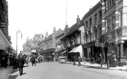
This view looks south to the old Town Hall, the building in the centre in the distance. The street is thronged with farmers and their families.

Crickhowell Castle lies 12 miles south-east of Brecon. The original stronghold was a timber motte and bailey, and belonged to the de Turberville family.

The river to the east of the church has been widened and landscaped, and bridges built to the north and south of the Churchyard.

Looking south just outside the centre of St Austell we see one of I K Brunel's timber viaducts on stone piers built in 1858 for the new Cornwall Railway.

This is taken from the north end of the Green, looking south towards Hall Street, showing the wide expanse of the Green, where fairs are still held.

Situated 4.5 miles south of Birmingham, Bournville was chosen by George Cadbury in 1879 as the site for his new factory and for a model village for his workers.

This sizeable hamlet on the Downs south of Harting has no church, but boasts some attractive flint cottages and fine scenery.There is plenty of history here: Bow Hill was a great Stone Age centre

Lancaster is on the edge of the Lake District, and an important point on routes both north and south.

The south face was undergoing repair work at this time. Pollution, mainly from the smoke from the railways, did a lot of damage to both glass and stone.

Now merged with Dorking, North Holmwood is one of three small villages along the west side of the large and mostly wooded Holmwood Common - the other two villages are Mid Holmwood and South

Some parts of the south-east wing go back to the 14th century, and the clock over the entrance has been marking the passing of time for about 350 years.

The main line railway station is to the south of the village centre.
Places (15471)
Photos (5054)
Memories (1580)
Books (1)
Maps (2499)

