

Places
36 places found.
Did you mean: street or streetly ?
Those places high-lighted have photos. All locations may have maps, books and memories.
- Heathfield, Sussex (near Cade Street)
- Street, Somerset
- Chester-Le-Street, Durham
- Adwick Le Street, Yorkshire
- Scotch Street, County Armagh
- Friday Street, Surrey
- Potter Street, Essex
- Boughton Street, Kent
- Newgate Street, Hertfordshire
- Streetly, West Midlands
- Shalmsford Street, Kent
- Green Street Green, Greater London
- Boreham Street, Sussex
- Park Street, Hertfordshire
- Cade Street, Sussex
- Appleton-le-Street, Yorkshire
- Hare Street, Hertfordshire (near Buntingford)
- Romney Street, Kent
- Trimley Lower Street, Suffolk
- Streetly End, Cambridgeshire
- Hare Street, Hertfordshire (near Stevenage)
- Brandish Street, Somerset
- Colney Street, Hertfordshire
- Langley Street, Norfolk
- Silver Street, Somerset (near Street)
- Street, Yorkshire (near Glaisdale)
- Street, Lancashire
- Street, Devon
- Street, Cumbria (near Orton)
- Street, Somerset (near Chard)
- Bird Street, Suffolk
- Black Street, Suffolk
- Ash Street, Suffolk
- Broad Street, Wiltshire
- Brome Street, Suffolk
- Penn Street, Buckinghamshire
Photos
21,809 photos found. Showing results 1,041 to 1,060.


Maps
1,622 maps found.


Books
1 books found. Showing results 1,249 to 1.
Memories
6,667 memories found. Showing results 521 to 530.
High Street
I can remember being taken shopping in the High Street, to Sainsbury's before it was a supermarket. There were tiled floors and walls, wooden counters with cheeses, cold meats and bacon, and the assistants wore their hair in nets or hats. ...Read more
A memory of Ashford in 1956 by
The Odfellows Arms In Front Street
I have just discovered from resaerching the census results that my Great Grandparents ran the Odfellows Arms in Witton Gilbert round about the turn of the last century. His name was John McCormick and he was ...Read more
A memory of Witton Gilbert in 1900 by
Now O'connell Street
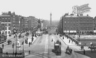
The street was officially renamed O'Connell Street in 1924 after Daniel O'Connell as Ireland moved forward as a free state! Nelsons Pillar seen in the distance (middle) was destroyed in the early morning on the 8th of March 1966 by ...Read more
A memory of Dublin by
Now The Top Pedestrianised Shopping Street In Ireland!
This is now famously the most exclusive shopping street in Dublin & Ireland too. The 7th most expensive rental prices in Europe with some retail outlets actually beating the world records making ...Read more
A memory of Dublin by
Born In Ilford
Ilford Town Hall is on the corner of Oakfield Road where I lived throughout WW2. The public Air Raid Shelter we used to sleep in was opposite the Town Hall in Oakfield Road. A very large department store called Moultons was opposite, in ...Read more
A memory of Ilford in 1940 by
My Grandfather
My grandfather, John Wilson, is entered as being Captain of Steam Boat Ferry in the 1901 census of Fleetwood. Although the ferry boat pictured does not appear to be steam, this sight must have been very familiar to him and his family who lived in nearby Pharos Street.
A memory of Fleetwood by
Read Brothers
My mother and father worked for Mr Read between 1966 and 1987, most of the time around the Hall Road shop but later in the mid to late 1980's also up in the High Street shop, which has been pulled down and a new shop built. Mr Read died ...Read more
A memory of Aveley in 1970 by
Harry Street
My gran lived on Harry Street in the 1960's and early 70's. I remember playing near the Trafford swing bridge and the excitement when it was opened. Old terraced houses slums by then. Corner shops and the horrible smell from the canal. ...Read more
A memory of Salford by
98 & 100 High Street
These two shops in the High Street in Crowle were owned by my grandmother Rose Raper. They were handed down to my father and aunt. My dad Raymond Raper had the grocers shop at number 98 and we lived above the shop until I was ten ...Read more
A memory of Crowle by
On The Street Where I Lived
The photo shows the bottom of Highwalls Avenue, I lived half way up round the corner. It was a steep climb when i was litlle but got easier as I grew. I was born in this road and had such a happy time.
A memory of Dinas Powis in 1950 by
Captions
5,381 captions found. Showing results 1,249 to 1,272.

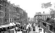
This busy junction, uniting five roads, including Northampton Road and Sheep Street, was lit by a single, central lamp post.

A rare surviving example of an English belfry, the Clock Tower, built in 1411, stands at the centre of the city with the narrow mediaeval street of French Row on its left and the wider Market Place on

Designed by architect George Vialls for the Mayor, Thomas Embray Davenport Philpot, the museum in Bridge Street was built in 1901.

With St Mary's Church in the distance, Church Street is typical of a market town by-way in the early 1950s.

It stands at the corner of Ballymagee Street, a name which was not thought quite suitable; it eventually became High Street.

The first shop was in a house in South Street, and then new premises were found in Swan Street, to the left of the island site. As business grew, it moved in 1875 to this site in Bocking End.

Roman remains are extant at Caldecott, but it is the later thatched and slated farmhouses, and rows of cottages (some with date panels) fronting onto the High Street which present a unified entity

East Bridge, at the eastern end of East Street (left), was built by J and T Gale in 1784 and has been widened.

Workers took up residence on a grid-iron of industrial streets, and the town boomed.

The High Street, which forms part of the Roman Watling Street, has been devastated by road widening in the 1930s.

The Bay Tree Café (left) survives today, and so does T P Hughes & Son (at the furthest visible end of the High Street), established in 1902.

Cranbrook's High Street, entering the town from Hawkhurst, and Stone Street, leading on towards Tenterden and Maidstone, form a L-shape with the tile-hung fascia of the 15th-century George Hotel at

The south-west side of Ware High Street changed drastically when it was decided to build a new Tesco Store in 1960.

Further down the street are No 21 (formerly the Dorsetshire Bank), and the Three Cups Hotel (projecting, centre).
Roman remains are extant at Caldecott, but it is the later thatched and slated farmhouses, and rows of cottages (some with date panels) fronting onto the High Street which present a unified entity

Hitchman's, the chemist on the left, was on the corner of Silver Street and Gold Street.

Here we see Grainger Street before work began on electrification of the street tramway.
East Bridge, at the eastern end of East Street (left), was built by J and T Gale in 1784 and has been widened.

Old Fore Street, later known as Culverhay, by 1912 was a mixture of architectural styles and had a good selection of shops.

The fixing of egg prices each week was decided on the High Street until 1939, when Garstang lost that privilege. Preston Co-op (left) with Martin's Bank next door faces the King's Arms.
The first shop was in a house in South Street, and then new premises were found in Swan Street, to the left of the island site. As business grew, it moved in 1875 to this site in Bocking End.
Cranbrook's High Street, entering the town from Hawkhurst, and Stone Street, leading on towards Tenterden and Maidstone, form a L-shape with the tile-hung fascia of the 15th-century George Hotel at

We are looking south-west from the Memorial Park; John Street and St Anselm`s Church and school are behind Market Street. Three air raid shelters are in the field in front of the church.
 c.1960, Abingdon-on-Thames")
In this view the photographer was looking left into East St Helen Street and right into the start of the High Street.
Places (385)
Photos (21809)
Memories (6667)
Books (1)
Maps (1622)

