

Places
36 places found.
Those places high-lighted have photos. All locations may have maps, books and memories.
- Shanklin, Isle of Wight
- Ventnor, Isle of Wight
- Ryde, Isle of Wight
- Cowes, Isle of Wight
- Sandown, Isle of Wight
- Port of Ness, Western Isles
- London, Greater London
- Cambridge, Cambridgeshire
- Dublin, Republic of Ireland
- Killarney, Republic of Ireland
- Douglas, Isle of Man
- Plymouth, Devon
- Newport, Isle of Wight
- Southwold, Suffolk
- Bristol, Avon
- Lowestoft, Suffolk
- Cromer, Norfolk
- Edinburgh, Lothian
- Maldon, Essex
- Clacton-On-Sea, Essex
- Felixstowe, Suffolk
- Norwich, Norfolk
- Hitchin, Hertfordshire
- Stevenage, Hertfordshire
- Colchester, Essex
- Nottingham, Nottinghamshire
- Bedford, Bedfordshire
- Bury St Edmunds, Suffolk
- Aldeburgh, Suffolk
- St Albans, Hertfordshire
- Hunstanton, Norfolk
- Chelmsford, Essex
- Bishop's Stortford, Hertfordshire
- Peterborough, Cambridgeshire
- Brentwood, Essex
- Glengarriff, Republic of Ireland
Photos
11,145 photos found. Showing results 3,241 to 3,260.


Maps
181,031 maps found.


Books
442 books found. Showing results 3,889 to 3,912.
Memories
29,068 memories found. Showing results 1,621 to 1,630.
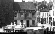
Swan Inn
My grandparents used to run this pub - Joseph and Elsie Wall, although I am not sure of the time they were there but I think it was around the 1940s.
A memory of Selby by
Eustace Street School
I was born in Chadderton in 1953, in my grandfather's house on Bamford Street. I attended Eustace Street School and the memories of my time there have shaped my life. I simply adored school and I am now a Special Needs ...Read more
A memory of Chadderton in 1964 by
Growing Up In Tideswell
Memories abound about my childhood, jumping and leaping like a rabbit at Eastertime. I remember staying at my grandmother's (Norah Gregory, a marvellous woman from the no-moaner generation), or at my Great Aunty Jessie's ...Read more
A memory of Tideswell in 1976 by
Broadlads Estate
My grandfather farmed Bushey Leazes farm on the Broadlands estate until his retirement. I loved that farm, playing in hay lofts, milking the cows, they had guard geese that would come down the long lane from the farm and not let you ...Read more
A memory of Romsey in 1949 by
Childhood Memories Of Penrhyn Bay
My grandmother and grandfather lived at "Oaklands", in Maesgwyn Road, opposite a corrugated iron church. The road was unmade and beyond the church to the sea was a large meadow where cattle and sheep grazed. On the ...Read more
A memory of Penrhyn in 1930
Shops
Picture shows the junction of Main Road with Crossways. I moved to Crossways aged 7 in 1961. The shop on the corner by the phone box was a Co-op, and the one on the far side of Crossways was a Post Office. From 1961 to 1970 I caught the bus ...Read more
A memory of Gidea Park in 1963 by
Mascot Hotel
I can't help with a photo - but I can confirm that the Mascot Hotel was in York Street. I stayed there for a couple of nights in June 1958. As I recall, the hotel was about 1/3 way down York Street on the right coming from the direction of Baker street. John Cavill
A memory of London in 1958 by
Hopton Hill
My family were from this area and my grandfather Edward Gough Jones and grandmother Rosa Jones brought up 7 children Joan, Nora, twins Eileen and Beryl, Ron (who still lived in a bungalow at the Crescent Nesscliffe until this year ...Read more
A memory of Nesscliffe in 1910 by
Abc Minors,Trolley Buses, Lonesome School, Oakleigh Way
I have just found this page and what memories it rekindles. I was a minor at the ABC, I even got a road safety prize from Coco the Clown. Thorpes record shop accross the road, there I bought my ...Read more
A memory of Mitcham in 1955 by
Air Raids
These memories are as fresh in my mind as if they happened last week. Boston had its share of air raids, the first one was on a rainy Monday, it was July, the first day of our summer school holidays. It would be about 7.15 am when we heard a ...Read more
A memory of Boston in 1940 by
Your search returned a large number of results. Please try to refine your search further.
Captions
29,395 captions found. Showing results 3,889 to 3,912.

Walking is one of the very best ways to explore the delights of the Isle of Wight.

It was owned by the Benedictine abbey of nearby Pershore until the Dissolution of the Monasteries by Henry VIII. Notice the oil lamp standard in the foreground of this late Victorian photograph.

Golden Cap, 626ft high, is the biggest cliff on the southern coast of England.

The name of this Whitbread pub, the King Ethelbert, is in remembrance of the Saxon king who ruled Kent from AD560-616. Part of the pub is built on an old Roman fort. Nearby there is a caravan site.

This was a Cistercian abbey founded in 1135 by Roger de Clinton, Bishop of Coventry and Lichfield.

Here we see a fairly busy scene in the centre of this large and expanding village.

Across the road the half-round windows, on the ground floor of the single-storey building on the right, show the site of the original Roman Bath, in constant use from that time.

Sir Henry Thompson, son of a vice admiral and curate of the parish church of St Peter and St Paul, helped to found Holy Trinity Church in West Street, as well as church schools in Park Lane and Fontley

There are some fine memorials within the church, notably those of the Oglander family, who had held land nearby since the Norman Conquest.

Miss Beale was a great campaigner for university education for women, and had a vision of the Ladies' College as a preparation for this.

Fore Street boasts many excellent examples of Georgian and Victorian architecture, with a Shambles and market arcade rebuilt in 1796.

The Market Square of Beccles is overlooked by the detached tower of St Michael's church.

In this 1929 photograph the north side of Hermitage Road is now built up, while the south side remains partly undeveloped.

The Minster Crypt 1886 There are many fine tombs within the Minster, including that of Saint Ethelred, a brother of Alfred, who was killed by the Danes in 873.

Southsea started life as a group of farm cottages but by the time this photograph was taken, it bore the stamp of a classic seaside resort, characterised by the terraces, villas and open spaces so typical

This photograph shows the layout of Beverley well, with North Bar leading to the Market Place. It also reveals more detail of the west front of St Mary's Church.

The black and white half-timbered frame of the building at the rear of the inn shows the influence of the Warwickshire Vale building methods on this Cotswold village.

This view looks from the top of King Street down towards Cross Street. We can see that the street narrows towards the bottom.

Inside this expansive parish church the many signs of the Early English era are manifest in the pulpit, for instance, which is inscribed and dated 1631 on a large arched panel with a good helping

The path leads down to the church of All Saints and St James the Greater.

An iron pot containing a large number of coins of Edward the Confessor was found in 1876. They were thought to have belonged to King Harold, and hidden during the Battle of Hastings.

Preston docks were once some of the busiest in the country, handling cargoes from around the world.

This crowded region south of the river was once the heart of London cockney life.

In the 1850s, Cheapside was one of the most fashionable shopping streets in London, with a ‘mighty stream of traffic’ flowing through from Oxford Street to Leadenhall and the City.
Places (6814)
Photos (11145)
Memories (29068)
Books (442)
Maps (181031)

