

Merry Christmas & Happy New Year!
Christmas Deliveries: If you placed an order on or before midday on Friday 19th December for Christmas delivery it was despatched before the Royal Mail or Parcel Force deadline and therefore should be received in time for Christmas. Orders placed after midday on Friday 19th December will be delivered in the New Year.
Please Note: Our offices and factory are now closed until Monday 5th January when we will be pleased to deal with any queries that have arisen during the holiday period.
During the holiday our Gift Cards may still be ordered for any last minute orders and will be sent automatically by email direct to your recipient - see here: Gift Cards
Places
36 places found.
Those places high-lighted have photos. All locations may have maps, books and memories.
- Shanklin, Isle of Wight
- Ventnor, Isle of Wight
- Ryde, Isle of Wight
- Cowes, Isle of Wight
- Sandown, Isle of Wight
- Port of Ness, Western Isles
- London, Greater London
- Cambridge, Cambridgeshire
- Dublin, Republic of Ireland
- Killarney, Republic of Ireland
- Douglas, Isle of Man
- Plymouth, Devon
- Newport, Isle of Wight
- Southwold, Suffolk
- Bristol, Avon
- Lowestoft, Suffolk
- Cromer, Norfolk
- Edinburgh, Lothian
- Maldon, Essex
- Clacton-On-Sea, Essex
- Felixstowe, Suffolk
- Norwich, Norfolk
- Hitchin, Hertfordshire
- Stevenage, Hertfordshire
- Colchester, Essex
- Nottingham, Nottinghamshire
- Bedford, Bedfordshire
- Bury St Edmunds, Suffolk
- Aldeburgh, Suffolk
- St Albans, Hertfordshire
- Hunstanton, Norfolk
- Chelmsford, Essex
- Bishop's Stortford, Hertfordshire
- Peterborough, Cambridgeshire
- Brentwood, Essex
- Glengarriff, Republic of Ireland
Photos
11,145 photos found. Showing results 15,201 to 11,145.
Maps
181,031 maps found.


Books
442 books found. Showing results 18,241 to 18,264.
Memories
29,073 memories found. Showing results 7,601 to 7,610.
The Shops I Remember
I think the photo must have been taken in 1961 or 1962, as the "new" or "top" shops are there; the original parade from the 1930s are taller than the later ones which can be seen at the top of the hill. From left to right, ...Read more
A memory of Chelsfield in 1962 by
Up The Wood
We had no TVs, and there was not much on the radios so we made our own entertainment. One activity was playing up the local wood. We had two woods close to East Howle. One was called the Side Wood and the other was known as the Middle ...Read more
A memory of East Howle in 1950 by
Netley Football Club
I was born in Netley Abbey in 1962. My dad and uncle were joint managers of Netley F.C. who had their ground at the rec down by the waterfront. I was only 11 when my uncle died and 12 years old when my dad died so the memories I ...Read more
A memory of Netley in 1970 by
The Cowleys Of High Barnet
Dear Roland, How interesting - your memories of High Barnet. As far as I am aware - we were not related to the Sunderlands of Hadley. The Cowley family who lived in Cockfosters, would most probably be my Uncle ...Read more
A memory of High Barnet in 1940 by
Our First Visit To Eyam
My husband's family comes from the Derby area. Our son is very proud of his Derbyshire roots, and sought to buy a house close to Derby yet - if possble - in a village in the Peak District. He and his wife spent many days and ...Read more
A memory of Eyam by
Living With My Grandparents
I too remember Nelson very well. I was sent to live with my grandparents in Nelson when I was 3 years old. My grandfather owned the garage/cycle shop at 2 Dynevor Terrace. His name was Tom Bowen. I can ...Read more
A memory of Nelson in 1940 by
My Family
From 1941 I lived in Clowne with my grandmother Mrs Turner. I have many happy memories of my time there and I am wondering if anyone has any memories of the family, apart from myself, Patricia, there was Eva, Jimmy, Christine & Bobby.
A memory of Barlborough by
Eva Turner
My mother was a Nurse Tutor at Lord Mayor Treloars Hospital during the 1940s to the 1960s. I am wondering if anyone has any memories of her, I would be very happy to hear of them.
A memory of Alton in 1940 by
Home
I was born in Grassington in March 1953, in a small cottage in a row of three on Chaple Street. They were known as the "Monkey Houses", as they are probably, still known today. By true locals anyway. My father was born at the town hall as ...Read more
A memory of Grassington in 1953 by
St Georges School
This is from my gran, Eunice Burridge, now Smallman. " My main teacher was Mr Church at the school. I always remember walking across the iron bridge to reach Mr Allen, the headmasters, office. My first teacher was Mrs Forest. My ...Read more
A memory of Brentford in 1950 by
Your search returned a large number of results. Please try to refine your search further.
Captions
29,395 captions found. Showing results 18,241 to 18,264.

East of Gainsborough the Market Rasen road climbs the Lincoln Cliff, the limestone ridge which runs due north from Lincoln at about two hundred feet above sea level.

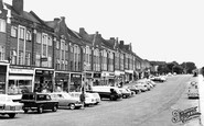
Olton Boulevard East is a long, wide road of mostly municipal housing, linking Warwick Road with Shaftmoor Lane.

Opposite was Booths the grocer's, part of a chain of shops, who ran a popular café upstairs.

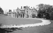
Christchurch was built by Edmund Withypoll in 1548-50, of red brick, on the site of Holy Trinity Priory. In 1893 the house and park were offered for sale.

This is taken from the 'tongues' in the middle of the River Brett, adjacent to the two 18th-century hump-backed bridges. The Peacock is early 15th-century.

This compact little village in a hollow south of the Hog's Back is benignly watched over by St Lawrence's Church, with its wooden 14th-century south porch.

These demure Victorian villas, constructed to house commuting City workers, are outwardly unchanged, although now augmented by two more modern houses on the right-hand side of the picture.

This small town, now part of Wrexham, was a mainly working-class community supplying workers for the various industries and mines in the area.

The houses on Pennine View are from a different era to the ones we saw in D210004, and catering for more modern workers.

The old road follows the line of the ridge and the beach was once occasionally used to load coal onto boats at high tide from the nearby Trefân Cliff Colliery.

The lanes and streets of Porlock wind delightfully between attractive whitewashed and thatched houses, including The Ship Inn with its characteristic external chimney stack in the centre of the street

Beyond the nave and the crossing is the medieval choir and sanctuary, the oldest part of the church, dating from the 12th to the 14th century. It is crowned by an 18th-century vaulted ceiling.

When digging foundations for the footings on the far side of the railway bridge the Victorian engineers discovered the remains of a Saxon fortification built in AD 915 by Queen Ethelfleda

It's amazing to think that Halton is now the centre of the modern town once more; history has turned full circle.

The old village of Weston, sitting on Runcorn Hill, has given its name to Weston Point where the docks and industries are largely to be found.

The buildings all survive but the whole view has changed considerably with, believe it or not, a much narrower road.

Looking at their family tree, one can see how the Gregs were connected to many other important inventors and industrialists of the time, including Josiah Wedgwood and the Darbies of Coalbrookdale

Off the Lizard, fearsome rocks are a constant reminder of why a lifeboat station was established in 1859 in the very exposed Polpeor Cove right under the most southerly point in England

It has been damaged on a number of occasions by passing lorries. The 4ft-high figure of the blacksmith then has to be repaired by a firm that makes traditional merry-go- rounds.

The main Huddersfield to Manchester railway makes its way along the steep side of the valley, and it has to cross many side valleys.

A gas lamp stands in the middle of the square, where the market cross once stood. A pestle and mortar (still present) proclaims that Mackereth, late Mason, is a chemist's shop.

Burford sits right on the county boundary with Herefordshire - the boundary is defined by the River Teme at this point.

In order to compare this picture with picture number O1044, look for the gable end with the two chimneys as a point of reference.

Standing some 800ft up, rising in green terraces above the village, it affords panoramic views with the erosion caused by rivers and frost action during the Ice Ages evident in the isolation of the
Places (6814)
Photos (11145)
Memories (29073)
Books (442)
Maps (181031)

