

Places
36 places found.
Those places high-lighted have photos. All locations may have maps, books and memories.
- Shanklin, Isle of Wight
- Ventnor, Isle of Wight
- Ryde, Isle of Wight
- Cowes, Isle of Wight
- Sandown, Isle of Wight
- Port of Ness, Western Isles
- London, Greater London
- Cambridge, Cambridgeshire
- Dublin, Republic of Ireland
- Killarney, Republic of Ireland
- Douglas, Isle of Man
- Plymouth, Devon
- Newport, Isle of Wight
- Southwold, Suffolk
- Bristol, Avon
- Lowestoft, Suffolk
- Cromer, Norfolk
- Edinburgh, Lothian
- Maldon, Essex
- Clacton-On-Sea, Essex
- Norwich, Norfolk
- Felixstowe, Suffolk
- Hitchin, Hertfordshire
- Stevenage, Hertfordshire
- Colchester, Essex
- Nottingham, Nottinghamshire
- Bedford, Bedfordshire
- Bury St Edmunds, Suffolk
- Aldeburgh, Suffolk
- St Albans, Hertfordshire
- Hunstanton, Norfolk
- Chelmsford, Essex
- Bishop's Stortford, Hertfordshire
- Peterborough, Cambridgeshire
- Brentwood, Essex
- Glengarriff, Republic of Ireland
Photos
9,106 photos found. Showing results 8,941 to 8,960.


Maps
181,006 maps found.


Books
11 books found. Showing results 10,729 to 11.
Memories
29,058 memories found. Showing results 4,471 to 4,480.
South Stifford And Grays
After my grandparents passed away the house was left to my father bill mercer.we lived at 64 Charlton street south stifford.I remember the cement works very well as I along with my friends peter Baldwin and Dave whitehead we ...Read more
A memory of Grays in 1964 by
My Dad
My dad was a life guard here, l'm guessing a few years before l was born. Many happy memories of being here with my cousin, though bikini top shifting whilst getting out of the pool wasn't good in my teenage years.
A memory of Aldershot by

Mario Lanza
When I was a boy, does anyone remember the Cocozza's who had the cafe in Craigneuk? The old man used to have a cycle with an attachment to carry ice-cream for sale in the Craigneuk area. I seem to remember that Mario Lanza ...Read more
A memory of Wishaw in 1953 by
Patrick And Cissie Mc Closkey
My memory refers to Paddy Mc Closkey who died on 21st December last at the Mater Hospital, Dublin. My quest is to find the grave of his mother- I am assuming she has departed this life- so as Paddy can be buried with her. ...Read more
A memory of Dublin by
The Good Old Days Berwick Street L6 1950's
My name is Audrey Hinds, i grew up in Berwick street in the 1950's. If anyone was there and has memories of this time please contact me, it would be lovely to share stories.
A memory of Liverpool in 1950 by
Edward Road Balsall Heath
my maiden name was Pamela gillett and I lived at 53 Edward Road Balsall Heath during the 40 50s our house was right opposite the Police Station and ARP yard. Have happy memories of Tindall Street school and then college ...Read more
A memory of Birmingham in 1950 by
My Cousin Lucy
I had a younger cousin called Lucy and unfortunately owing to divorce she ended up living with the nuns at St Claires. I used to visit her and she'd sometimes came to stop at my home on weekends - she got on well with my four ...Read more
A memory of Pantasaph by
Dogdyke County Primary School
Being born in 1957 I attended Dogdyke County Primary school from 1962 whilst living with parents in Witham Drive, Chapel Hill. We used to walk or cycle to school in those days. Shortly after then we moved to Tattershall ...Read more
A memory of Dogdyke in 1962
Hornbeam Road
Having accidentally found this forum today, and added a few memories of Queens Road toy shop. I have now had some time to read most of the contributions. There are so many memory joggers here from the likes of David Killen and ...Read more
A memory of Buckhurst Hill by
Your search returned a large number of results. Please try to refine your search further.
Captions
29,158 captions found. Showing results 10,729 to 10,752.

This is a classic view of Neville Street, with the entrance to the Central Station on the left and St Mary's Roman Catholic Church in the background.

This is a closer view of the car in the previous picture. This Singer Junior was first registered in Dorset in November 1929. The vehicle cost about £140, and had a top speed of 56 miles per hour.

One of the ways farmers cheated their customers was to fill only the top portion of the 14lb butter jars and leave the remainder empty.

The Infirmary (on the right) was built opposite Coleman & Morton's ironworks - a firm that had specialised in ploughs and cultivators, but closed as a result of the agricultural depression.
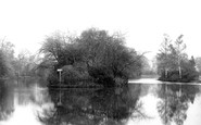
This view is taken from the Prebend Street Bridge on the south side of the tree-covered eyot in the middle of the river.

When this view was taken, it was nearly 20 years after the opening of the pool in Bishop's Road.

This view is taken from the meadow beside the canal, the Aylesbury Arm of the Grand Union Canal, which opened in 1815. The meadow is now occupied by 1990s housing, Hilda Wharf.

On the left is the 1938 neo-Georgian Marks and Spencer's that replaced Longleys. The rest of the buildings are in their last few years of existence.

Moving east, the route passes through Whitchurch on its way back to Aylesbury.

Having your photograph taken was part of a holiday, and these booths would take your photograph and turn out six or twelve copies in about an hour.

This picture gives us a good view of Marine Drive, built in 1894 as the sea retreated. The Drive created a large area of water around the pier, which was known locally as the Lagoon.

The sunny summers of the 1950s filled this pool, which had excellent amenities – a café, changing rooms, diving boards, and sunbathing and spectator areas.

By this time, Cromer had developed into a select holiday resort for the well-to-do, many of whom stayed in the Cliftonville Hotel (right) facing the west beach.

Framed beneath the spreading tree, which previously stood within the boundary of Whitehall before the road-widening process was embarked on in the 1930s, is this view of the Broadway looking south.

Newport grew rapidly with the arrival of the Market Weighton canal in the 18th century; it was the final loading place before crossing a short distance to the Humber.

In medieval times Tickhill, which lies 4 miles south of Doncaster, was more important than Sheffield; its castle, built about 1130, was one of the most important in the north - we can just

The elegant, classical façade of the Shire Hall has dominated the Market Square since it was built in 1798, replacing an earlier Elizabethan hall.

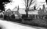
The parish church of St Peter and St Paul, a favourite dedication of King Ine in Anglo-Saxon times, stands on a knoll overlooking Uplyme village.

A large map showing the streets of Weybridge to help visitors has now joined the oak shelter, and the bus stop outside the Ship Inn is now more prominent.

This thoroughfare is a continuation of Westgate and Park Lane, and at 80 ft wide is 10 ft wider than Union Street, Aberdeen.

The older parts of Chipstead village are on the chalk ridge above the dry valley some 150 feet below, along which Chipstead Valley Road runs.

The streetscape is dominated by the former Burton's building, an urban interloper of 1939 with its giant Ionic pilasters supporting a heavy cornice.

On the right is St Peter's, the parish church of Blaenavon, built by the ironmasters Hopkins and Hill in 1805.

The magnificence of the church was rather spoilt by the 18th-century red brick tower with classical blank arches and windows (see photograph 35493), built after much of the medieval tower
Places (6814)
Photos (9106)
Memories (29058)
Books (11)
Maps (181006)

